Property Record
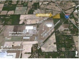
16131 Peggy Rd, Alachua, FL 32615

Property Detail
16131 Peggy Rd
03904-000-000
NW1/4 OF SE1/4 S & E OF RR R/W ALSO 100 FT ABANDONED RR/W ADJ PER OR 708/447 (LESS COM SW COR OF NW1/4 OF SE1/4 POB N 648.73 FT N 59 DEG E 344.19 FT S 828.20 FT W 295 FT POB PER OR 2004/0956) OR 4994/0999
Timberlandforesttreesagricultural
ALACHUA
A
Florida
B and X Area of moderate flood hazard, usually the area between the limits of the 100-year and 500-year floods.
28.43 AC
2025
Gainesville
2025
Other Market Areas
001819
Gainesville, FL
934 SF
NEARBY LISTINGS FOR SALE OR LEASE
DEMOGRAPHICS near 16131 Peggy Rd
1 mile
3 mile
5 mile
2025 Total Population
1,184
11,165
16,003
2030 Population
1,243
11,720
16,816
Pop Growth 2025-2030
+ 4.98%
+ 4.97%
+ 5.08%
Average Age
41
41
42
2025 Total Households
470
4,492
6,355
HH Growth 2025-2030
+ 5.74%
+ 5.52%
+ 5.65%
Median Household Inc
$68,527
$81,933
$84,909
Avg Household Size
2.50
2.50
2.50
2025 Avg HH Vehicles
2.00
2.00
2.00
Median Home Value
$305,789
$331,679
$336,992
Median Year Built
1996
1995
1996
Nearby Places
Map Layers
Map Styles
 Street
 Aerial
Layers
 Traffic
 Biking
Places
Listings with unknown addresses are not visible on the map
- Restaurants
- Banks
- Shops
- Fitness
- Groceries
PUBLIC TRANSPORTATION
AIRPORT
Gainesville Regional
Drive
Walk
Distance
Gainesville Regional
33 min
18.7 mi
Freight Ports
Jacksonville Port
Drive
Walk
Distance
Jacksonville Port
116 min
81.7 mi
Nearby Properties
Address
Land Use
TOTAL SIZE
Lot Size
Zoning
Address
Land Use
TOTAL SIZE
Lot Size
Zoning
204,258 SF
23.24 AC
ILW
Address
Land Use
TOTAL SIZE
Lot Size
Zoning
1,098,236 SF
230.50 AC
IG
Address
Land Use
TOTAL SIZE
Lot Size
Zoning
970,425 SF
204.08 AC
IG
Address
Land Use
TOTAL SIZE
Lot Size
Zoning
526,018 SF
208.06 AC
IG
Address
Land Use
TOTAL SIZE
Lot Size
Zoning
1,296,224 SF
67.06 AC
A
Address
Land Use
TOTAL SIZE
Lot Size
Zoning
318,416 SF
22.90 AC
RMF-15
Address
Land Use
TOTAL SIZE
Lot Size
Zoning
147,781 SF
17.01 AC
PUD
Address
Land Use
TOTAL SIZE
Lot Size
Zoning
99,873 SF
34 AC
A
Address
Land Use
TOTAL SIZE
Lot Size
Zoning
200,050 SF
18.60 AC
RSF-3
Address
Land Use
TOTAL SIZE
Lot Size
Zoning
76,504 SF
20 AC
RSF-3
Address
Land Use
TOTAL SIZE
Lot Size
Zoning
28,727 SF
6.04 AC
PUD
Address
Land Use
TOTAL SIZE
Lot Size
Zoning
56,468 SF
4.25 AC
Address
Land Use
TOTAL SIZE
Lot Size
Zoning
43,646 SF
4.90 AC
ILW
Address
Land Use
TOTAL SIZE
Lot Size
Zoning
64,076 SF
2.73 AC
CI
Address
Land Use
TOTAL SIZE
Lot Size
Zoning
40,804 SF
3.94 AC
ILW
Address
Land Use
TOTAL SIZE
Lot Size
Zoning
95,185 SF
7.72 AC
CI
Address
Land Use
TOTAL SIZE
Lot Size
Zoning
380.19 AC
IG
Address
Land Use
TOTAL SIZE
Lot Size
Zoning
196,628 SF
17.11 AC
IG
Address
Land Use
TOTAL SIZE
Lot Size
Zoning
42,695 SF
10.66 AC
CI
Address
Land Use
TOTAL SIZE
Lot Size
Zoning
41,464 SF
3.96 AC
PUD
Address
Land Use
TOTAL SIZE
Lot Size
Zoning
54,768 SF
11.63 AC
ILW
Address
Land Use
TOTAL SIZE
Lot Size
Zoning
125,982 SF
23.50 AC
CI
Address
Land Use
TOTAL SIZE
Lot Size
Zoning
23,683 SF
6.02 AC
ILW
Address
Land Use
TOTAL SIZE
Lot Size
Zoning
69.50 AC
IG
Address
Land Use
TOTAL SIZE
Lot Size
Zoning
21,446 SF
4.05 AC
ILW
Address
Land Use
TOTAL SIZE
Lot Size
Zoning
37,274 SF
6.14 AC
PUD
Address
Land Use
TOTAL SIZE
Lot Size
Zoning
31,248 SF
3.27 AC
PUD
Address
Land Use
TOTAL SIZE
Lot Size
Zoning
132,880 SF
20 AC
IG
Address
Land Use
TOTAL SIZE
Lot Size
Zoning
52,486 SF
3.35 AC
IG
Address
Land Use
TOTAL SIZE
Lot Size
Zoning
38,024 SF
3.17 AC
CI
The World's #1 Commercial Real Estate Marketplace
Connect with us
© 2026 CoStar Group
The information above has been obtained from sources believed reliable. While we do not doubt its accuracy we have not verified it and make no guarantee, warranty or representation about it. It is your responsibility to independently confirm its accuracy and completeness. Any projections, opinions, assumptions, or estimates used are for example only and do not represent the current or future performance of the property. The value of this transaction to you depends on tax and other factors which should be evaluated by your tax, financial, and legal advisors. You and your advisors should conduct a careful, independent investigation of the property to determine to your satisfaction the suitability of the property for your needs.