Property Record
1615 E 12Th St, The Dalles, OR 97058
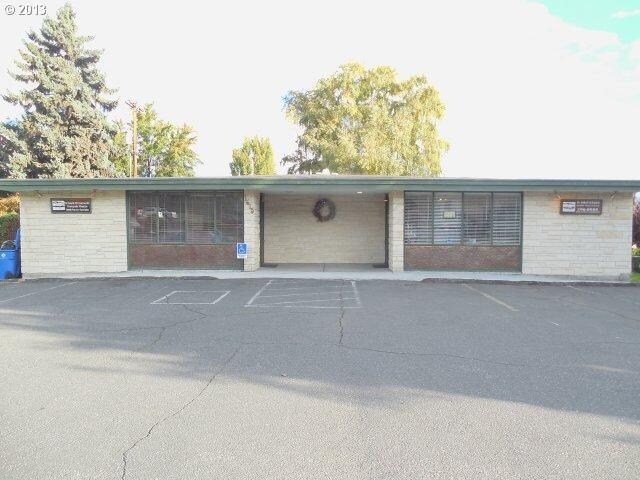

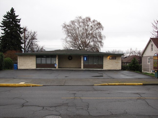

Property Detail
1615 E 12Th St
The Dalles, OR
SECTION 2 TOWNSHIP 1N RANGE 13E QUARTER CC PRCL 10400 MAPTAX LOT: 01N13 E02CC10400 00
4839
Wasco
Commercialnec
Oregon
RH
0.19 AC
2025
Oregon East Area
2025
Other Market Areas
970100
NEARBY LISTINGS FOR SALE OR LEASE
DEMOGRAPHICS near 1615 E 12Th St
1 mile
3 mile
5 mile
2025 Total Population
6,235
15,262
19,752
2030 Population
6,078
14,995
19,389
Pop Growth 2025-2030
(2.52%)
(1.75%)
(1.84%)
Average Age
41
41
41
2025 Total Households
2,391
5,865
7,624
HH Growth 2025-2030
(2.80%)
(2.01%)
(2.05%)
Median Household Inc
$74,509
$65,918
$64,232
Avg Household Size
2.50
2.40
2.50
2025 Avg HH Vehicles
2.00
2.00
2.00
Median Home Value
$396,890
$385,555
$379,268
Median Year Built
1955
1963
1970
Nearby Places
Map Layers
Map Styles
 Street
 Aerial
Layers
 Traffic
 Biking
Places
Listings with unknown addresses are not visible on the map
- Restaurants
- Banks
- Shops
- Fitness
- Groceries
Nearby Properties
Address
Land Use
TOTAL SIZE
Lot Size
Zoning
Address
Land Use
TOTAL SIZE
Lot Size
Zoning
Address
Land Use
TOTAL SIZE
Lot Size
Zoning
Address
Land Use
TOTAL SIZE
Lot Size
Zoning
Address
Land Use
TOTAL SIZE
Lot Size
Zoning
Address
Land Use
TOTAL SIZE
Lot Size
Zoning
5.52 AC
CG GENERAL
Address
Land Use
TOTAL SIZE
Lot Size
Zoning
3.01 AC
CR RECREAT
Address
Land Use
TOTAL SIZE
Lot Size
Zoning
12.37 AC
RL
Address
Land Use
TOTAL SIZE
Lot Size
Zoning
Address
Land Use
TOTAL SIZE
Lot Size
Zoning
3.69 AC
RH HIGH/ME
Address
Land Use
TOTAL SIZE
Lot Size
Zoning
Address
Land Use
TOTAL SIZE
Lot Size
Zoning
2.10 AC
CG
Address
Land Use
TOTAL SIZE
Lot Size
Zoning
3.74 AC
NC NBRHD C
Address
Land Use
TOTAL SIZE
Lot Size
Zoning
Address
Land Use
TOTAL SIZE
Lot Size
Zoning
3.49 AC
CG GENERAL
Address
Land Use
TOTAL SIZE
Lot Size
Zoning
4.13 AC
CG GENERAL
Address
Land Use
TOTAL SIZE
Lot Size
Zoning
Address
Land Use
TOTAL SIZE
Lot Size
Zoning
1.20 AC
Address
Land Use
TOTAL SIZE
Lot Size
Zoning
Address
Land Use
TOTAL SIZE
Lot Size
Zoning
4.28 AC
CG GENERAL
Address
Land Use
TOTAL SIZE
Lot Size
Zoning
7.78 AC
CG
Address
Land Use
TOTAL SIZE
Lot Size
Zoning
4.23 AC
Address
Land Use
TOTAL SIZE
Lot Size
Zoning
82.43 AC
I
Address
Land Use
TOTAL SIZE
Lot Size
Zoning
Address
Land Use
TOTAL SIZE
Lot Size
Zoning
2.02 AC
CG
Address
Land Use
TOTAL SIZE
Lot Size
Zoning
130,200 SF
Address
Land Use
TOTAL SIZE
Lot Size
Zoning
1.15 AC
RH
Address
Land Use
TOTAL SIZE
Lot Size
Zoning
3.41 AC
CG GENERAL
Address
Land Use
TOTAL SIZE
Lot Size
Zoning
7.23 AC
RH
Address
Land Use
TOTAL SIZE
Lot Size
Zoning
2.02 AC
CG GENERAL
The World's #1 Commercial Real Estate Marketplace
Connect with us
© 2026 CoStar Group
The information above has been obtained from sources believed reliable. While we do not doubt its accuracy we have not verified it and make no guarantee, warranty or representation about it. It is your responsibility to independently confirm its accuracy and completeness. Any projections, opinions, assumptions, or estimates used are for example only and do not represent the current or future performance of the property. The value of this transaction to you depends on tax and other factors which should be evaluated by your tax, financial, and legal advisors. You and your advisors should conduct a careful, independent investigation of the property to determine to your satisfaction the suitability of the property for your needs.