Property Record
164 Manning Gin Rd, Bethlehem, GA 30620

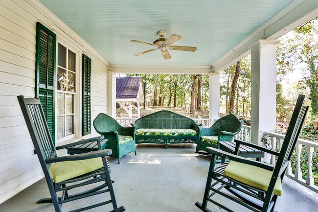
This Property Is For Sale
NEARBY LISTINGS FOR SALE OR LEASE
Property Detail
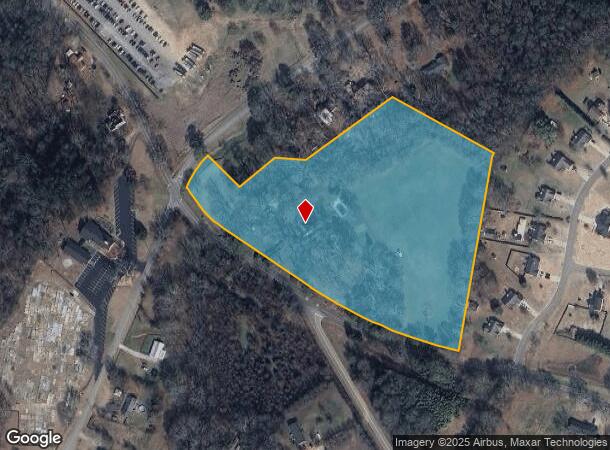
164 Manning Gin Rd
Atlanta-Sandy Springs-Roswell, GA
Calgary Downs Phase I
XX099-011
Barrow
Sfr
Georgia
X
10.42 AC
13297C0040E
Barrow County
3,043 SF
Atlanta
DEMOGRAPHICS near 164 Manning Gin Rd
1 Mile
3 Mile
5 Mile
2024 Total Population
1,338
10,263
38,071
2029 Population
1,526
11,782
43,883
Pop Growth 2024-2029
+ 14.05%
+ 14.80%
+ 15.27%
Average Age
37
37
37
2024 Total Households
448
3,392
12,976
HH Growth 2024-2029
+ 14.06%
+ 14.95%
+ 15.41%
Median Household Inc
$61,818
$67,186
$64,254
Avg Household Size
2.90
2.90
2.90
2024 Avg HH Vehicles
3.00
2.00
2.00
Median Home Value
$199,999
$226,296
$219,045
Median Year Built
1996
1999
2000
Nearby Places
Map Layers
Map Styles
 Street
 Aerial
- Restaurants
- Banks
- Shops
- Fitness
- Groceries
Nearby Properties
Address
Land Use
TOTAL SIZE
Lot Size
Zoning
Address
Land Use
TOTAL SIZE
Lot Size
Zoning
275,840 SF
22.10 AC
M-1
Address
Land Use
TOTAL SIZE
Lot Size
Zoning
85,000 SF
85.91 AC
AC
Address
Land Use
TOTAL SIZE
Lot Size
Zoning
2,046 SF
12.97 AC
B-2,R-3
Address
Land Use
TOTAL SIZE
Lot Size
Zoning
65,340 SF
11.81 AC
C-3
Address
Land Use
TOTAL SIZE
Lot Size
Zoning
3,370 SF
352.38 AC
G,TNPD
Address
Land Use
TOTAL SIZE
Lot Size
Zoning
37,162 SF
4.62 AC
R-3
Address
Land Use
TOTAL SIZE
Lot Size
Zoning
26,802 SF
5 AC
AG
Address
Land Use
TOTAL SIZE
Lot Size
Zoning
20,857 SF
39.58 AC
M-1
Address
Land Use
TOTAL SIZE
Lot Size
Zoning
24,982 SF
16.08 AC
R-1
Address
Land Use
TOTAL SIZE
Lot Size
Zoning
8,916 SF
67.07 AC
R-3
Address
Land Use
TOTAL SIZE
Lot Size
Zoning
46,339 SF
2 AC
B-2
Address
Land Use
TOTAL SIZE
Lot Size
Zoning
76,768 SF
19.04 AC
AG
Address
Land Use
TOTAL SIZE
Lot Size
Zoning
45,296 SF
8.18 AC
B-2
Address
Land Use
TOTAL SIZE
Lot Size
Zoning
143,025 SF
9.30 AC
M-1
Address
Land Use
TOTAL SIZE
Lot Size
Zoning
19,483 SF
2.76 AC
B-2
Address
Land Use
TOTAL SIZE
Lot Size
Zoning
34,355 SF
24.48 AC
AG
Address
Land Use
TOTAL SIZE
Lot Size
Zoning
18,240 SF
0.97 AC
B-2
Address
Land Use
TOTAL SIZE
Lot Size
Zoning
4,026 SF
1.58 AC
B-2
Address
Land Use
TOTAL SIZE
Lot Size
Zoning
47,130 SF
17.58 AC
M-1
Address
Land Use
TOTAL SIZE
Lot Size
Zoning
14,356 SF
2.29 AC
B-2
Address
Land Use
TOTAL SIZE
Lot Size
Zoning
13,439 SF
1.34 AC
B-2
Address
Land Use
TOTAL SIZE
Lot Size
Zoning
10,455 SF
1.97 AC
B-2
Address
Land Use
TOTAL SIZE
Lot Size
Zoning
11,928 SF
0.96 AC
B-2
Address
Land Use
TOTAL SIZE
Lot Size
Zoning
6,345 SF
1.84 AC
B-2
Address
Land Use
TOTAL SIZE
Lot Size
Zoning
4,500 SF
11.80 AC
M-1
Address
Land Use
TOTAL SIZE
Lot Size
Zoning
29,332 SF
4.90 AC
OI
Address
Land Use
TOTAL SIZE
Lot Size
Zoning
2,350 SF
238.88 AC
M-1
Address
Land Use
TOTAL SIZE
Lot Size
Zoning
7,200 SF
5.96 AC
M-1
Address
Land Use
TOTAL SIZE
Lot Size
Zoning
9,018 SF
1 AC
B-2,R-3
Address
Land Use
TOTAL SIZE
Lot Size
Zoning
15,625 SF
3.41 AC
G
The World's #1 Commercial Real Estate Marketplace
Connect with us
© 2025 CoStar Group
The information above has been obtained from sources believed reliable. While we do not doubt its accuracy we have not verified it and make no guarantee, warranty or representation about it. It is your responsibility to independently confirm its accuracy and completeness. Any projections, opinions, assumptions, or estimates used are for example only and do not represent the current or future performance of the property. The value of this transaction to you depends on tax and other factors which should be evaluated by your tax, financial, and legal advisors. You and your advisors should conduct a careful, independent investigation of the property to determine to your satisfaction the suitability of the property for your needs.