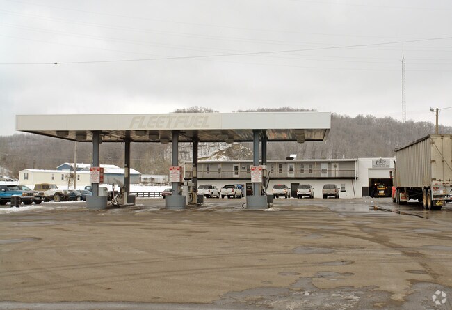
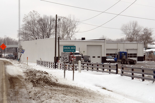
Property Record
164 State Route 650, Ironton, OH 45638

Property Detail
164 State Route 650
09-037-1000-000
19-01-11 R19 T01 S12 NE PT. S1/2 SE 0001.16A
Autorepair
LAWRENCE
AE The base floodplain where base flood elevations are provided. AE Zones are now used on new format FIRMs instead of A1-A30 Zones.
Ohio
2024
1.16 AC
2025
Lawrence County
050700
Huntington/Ashland
15,623 SF
Huntington-Ashland, WV-KY-OH
NEARBY LISTINGS FOR SALE OR LEASE
DEMOGRAPHICS near 164 State Route 650
1 mile
3 mile
5 mile
2025 Total Population
1,448
15,251
32,223
2030 Population
1,399
14,958
31,504
Pop Growth 2025-2030
(3.38%)
(1.92%)
(2.23%)
Average Age
42
43
43
2025 Total Households
596
6,343
13,166
HH Growth 2025-2030
(3.19%)
(1.97%)
(2.26%)
Median Household Inc
$49,999
$49,562
$55,045
Avg Household Size
2.40
2.30
2.30
2025 Avg HH Vehicles
2.00
2.00
2.00
Median Home Value
$122,884
$128,326
$136,773
Median Year Built
1967
1968
1968
Nearby Places
Map Layers
Map Styles
 Street
 Aerial
Layers
 Traffic
 Biking
Places
Listings with unknown addresses are not visible on the map
- Restaurants
- Banks
- Shops
- Fitness
- Groceries
PUBLIC TRANSPORTATION
COMMUTER RAIL
Drive
Walk
Distance
10 min
8.1 mi
AIRPORT
Tri-State/Milton J Ferguson Field
Drive
Walk
Distance
Tri-State/Milton J Ferguson Field
29 min
19.9 mi
Nearby Properties
Address
Land Use
TOTAL SIZE
Lot Size
Zoning
Address
Land Use
TOTAL SIZE
Lot Size
Zoning
Address
Land Use
TOTAL SIZE
Lot Size
Zoning
10,000 SF
12.85 AC
Address
Land Use
TOTAL SIZE
Lot Size
Zoning
3.86 AC
Address
Land Use
TOTAL SIZE
Lot Size
Zoning
Address
Land Use
TOTAL SIZE
Lot Size
Zoning
Address
Land Use
TOTAL SIZE
Lot Size
Zoning
75,820 SF
1.71 AC
Address
Land Use
TOTAL SIZE
Lot Size
Zoning
1,440 SF
1.38 AC
Address
Land Use
TOTAL SIZE
Lot Size
Zoning
135,431 SF
9.19 AC
Address
Land Use
TOTAL SIZE
Lot Size
Zoning
9,300 SF
7.65 AC
Address
Land Use
TOTAL SIZE
Lot Size
Zoning
5.14 AC
Address
Land Use
TOTAL SIZE
Lot Size
Zoning
Address
Land Use
TOTAL SIZE
Lot Size
Zoning
10,500 SF
14.80 AC
Address
Land Use
TOTAL SIZE
Lot Size
Zoning
5,280 SF
0.72 AC
Address
Land Use
TOTAL SIZE
Lot Size
Zoning
31,419 SF
10.43 AC
Address
Land Use
TOTAL SIZE
Lot Size
Zoning
36,040 SF
17.19 AC
Address
Land Use
TOTAL SIZE
Lot Size
Zoning
10,000 SF
15 AC
Address
Land Use
TOTAL SIZE
Lot Size
Zoning
1,500 SF
559.08 AC
Address
Land Use
TOTAL SIZE
Lot Size
Zoning
158,775 SF
24.40 AC
Address
Land Use
TOTAL SIZE
Lot Size
Zoning
116,720 SF
0.40 AC
Address
Land Use
TOTAL SIZE
Lot Size
Zoning
3,300,000 SF
0.53 AC
Address
Land Use
TOTAL SIZE
Lot Size
Zoning
Address
Land Use
TOTAL SIZE
Lot Size
Zoning
44,640 SF
1.96 AC
Address
Land Use
TOTAL SIZE
Lot Size
Zoning
12,046 SF
1.12 AC
Address
Land Use
TOTAL SIZE
Lot Size
Zoning
Address
Land Use
TOTAL SIZE
Lot Size
Zoning
3,460 SF
0.98 AC
Address
Land Use
TOTAL SIZE
Lot Size
Zoning
96 SF
1 AC
Address
Land Use
TOTAL SIZE
Lot Size
Zoning
9.72 AC
Address
Land Use
TOTAL SIZE
Lot Size
Zoning
1,104 SF
0.13 AC
Address
Land Use
TOTAL SIZE
Lot Size
Zoning
Address
Land Use
TOTAL SIZE
Lot Size
Zoning
1.21 AC
The World's #1 Commercial Real Estate Marketplace
Connect with us
© 2026 CoStar Group
The information above has been obtained from sources believed reliable. While we do not doubt its accuracy we have not verified it and make no guarantee, warranty or representation about it. It is your responsibility to independently confirm its accuracy and completeness. Any projections, opinions, assumptions, or estimates used are for example only and do not represent the current or future performance of the property. The value of this transaction to you depends on tax and other factors which should be evaluated by your tax, financial, and legal advisors. You and your advisors should conduct a careful, independent investigation of the property to determine to your satisfaction the suitability of the property for your needs.