Property Record
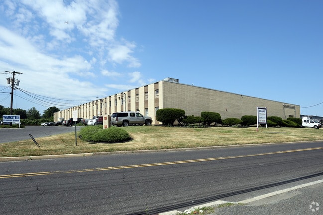
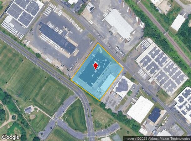
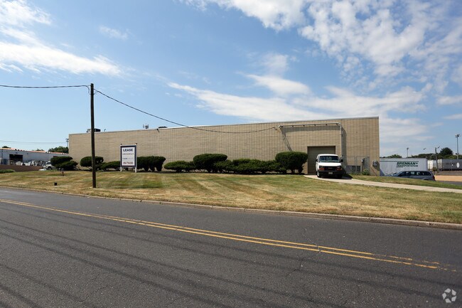
1601 Sherman Ave, Pennsauken, NJ 08110

NEARBY LISTINGS FOR SALE OR LEASE
Property Detail
1601 Sherman Ave
27-01102-0000-00011
Camden
Industrialgeneral
New Jersey
X
11
34005C0206F
3.33 AC
2024
Camden County
2025
Philadelphia
610500
Philadelphia-Camden-Wilmington, PA-NJ-DE-MD
DEMOGRAPHICS near 1601 Sherman Ave
1 Mile
3 Mile
5 Mile
2024 Total Population
11,595
111,331
525,470
2029 Population
11,475
111,225
517,285
Pop Growth 2024-2029
(1.03%)
(0.10%)
(1.56%)
Average Age
40
39
37
2024 Total Households
3,879
40,782
198,418
HH Growth 2024-2029
(1.11%)
(0.06%)
(1.54%)
Median Household Inc
$87,885
$69,906
$59,999
Avg Household Size
2.90
2.60
2.60
2024 Avg HH Vehicles
2.00
2.00
1.00
Median Home Value
$184,232
$197,021
$212,613
Median Year Built
1952
1954
1951
Nearby Places
Map Layers
Map Styles
 Street
 Aerial
- Restaurants
- Banks
- Shops
- Fitness
- Groceries
PUBLIC TRANSPORTATION
COMMUTER RAIL
DRIVE
WALK
Distance
3 min
1.1 mi
Cherry Hill (Atlantic City Line - NJ Transit Commuter Rail (NJ Transit))
DRIVE
WALK
Distance
Cherry Hill (Atlantic City Line - NJ Transit Commuter Rail (NJ Transit))
12 min
5.4 mi
AIRPORT
Philadelphia International
DRIVE
WALK
Distance
Philadelphia International
31 min
17.2 mi
Trenton Mercer
DRIVE
WALK
Distance
Trenton Mercer
49 min
30.2 mi
Freight Ports
South Jersey Port
DRIVE
WALK
Distance
South Jersey Port
12 min
5.5 mi
SALE & LEASE HISTORY
LISTING DATE
SALE/LEASE

Nov 09, 2018
For Lease
Mar 28, 2024
For Lease
Nearby Properties
Address
Land Use
TOTAL SIZE
Lot Size
Zoning
Address
Land Use
TOTAL SIZE
Lot Size
Zoning
66.02 AC
Address
Land Use
TOTAL SIZE
Lot Size
Zoning
Address
Land Use
TOTAL SIZE
Lot Size
Zoning
740,701 SF
47.70 AC
I2
Address
Land Use
TOTAL SIZE
Lot Size
Zoning
54.54 AC
Address
Land Use
TOTAL SIZE
Lot Size
Zoning
8.50 AC
Address
Land Use
TOTAL SIZE
Lot Size
Zoning
50.73 AC
C73A
Address
Land Use
TOTAL SIZE
Lot Size
Zoning
470,871 SF
41.87 AC
I3
Address
Land Use
TOTAL SIZE
Lot Size
Zoning
37.60 AC
Address
Land Use
TOTAL SIZE
Lot Size
Zoning
Address
Land Use
TOTAL SIZE
Lot Size
Zoning
12.80 AC
R20
Address
Land Use
TOTAL SIZE
Lot Size
Zoning
17.62 AC
Address
Land Use
TOTAL SIZE
Lot Size
Zoning
227,844 SF
19.82 AC
I2
Address
Land Use
TOTAL SIZE
Lot Size
Zoning
6.30 AC
Address
Land Use
TOTAL SIZE
Lot Size
Zoning
32.46 AC
Address
Land Use
TOTAL SIZE
Lot Size
Zoning
5.35 AC
Address
Land Use
TOTAL SIZE
Lot Size
Zoning
9,300 SF
1.30 AC
I3
Address
Land Use
TOTAL SIZE
Lot Size
Zoning
Address
Land Use
TOTAL SIZE
Lot Size
Zoning
Address
Land Use
TOTAL SIZE
Lot Size
Zoning
160,000 SF
137.74 AC
I3
Address
Land Use
TOTAL SIZE
Lot Size
Zoning
8.85 AC
Address
Land Use
TOTAL SIZE
Lot Size
Zoning
22.45 AC
MD
Address
Land Use
TOTAL SIZE
Lot Size
Zoning
37.39 AC
Address
Land Use
TOTAL SIZE
Lot Size
Zoning
24.24 AC
MW2
Address
Land Use
TOTAL SIZE
Lot Size
Zoning
118,400 SF
9.12 AC
CA2
Address
Land Use
TOTAL SIZE
Lot Size
Zoning
8,197 SF
51.22 AC
I3
Address
Land Use
TOTAL SIZE
Lot Size
Zoning
39.53 AC
Address
Land Use
TOTAL SIZE
Lot Size
Zoning
110,760 SF
1.10 AC
ICMX
Address
Land Use
TOTAL SIZE
Lot Size
Zoning
35.57 AC
Address
Land Use
TOTAL SIZE
Lot Size
Zoning
26.17 AC
Address
Land Use
TOTAL SIZE
Lot Size
Zoning
148,609 SF
8.84 AC
ICMX
The World's #1 Commercial Real Estate Marketplace
Connect with us
© 2026 CoStar Group
The information above has been obtained from sources believed reliable. While we do not doubt its accuracy we have not verified it and make no guarantee, warranty or representation about it. It is your responsibility to independently confirm its accuracy and completeness. Any projections, opinions, assumptions, or estimates used are for example only and do not represent the current or future performance of the property. The value of this transaction to you depends on tax and other factors which should be evaluated by your tax, financial, and legal advisors. You and your advisors should conduct a careful, independent investigation of the property to determine to your satisfaction the suitability of the property for your needs.