Property Record
1641 Universal Rd, Columbus, OH 43207
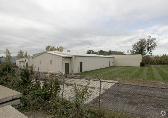


Property Detail
1641 Universal Rd
010-116020
1641 UNIVERSAL RD R22 T5 S26 1/2S38 1.241 ACRES
Storemultistory
Franklin
B and X Area of moderate flood hazard, usually the area between the limits of the 100-year and 500-year floods.
Ohio
2024
1.24 AC
2025
Downtown South
008730
Columbus
8,515 SF
Columbus, OH
NEARBY LISTINGS FOR SALE OR LEASE
DEMOGRAPHICS near 1641 Universal Rd
1 mile
3 mile
5 mile
2025 Total Population
7,741
107,149
255,612
2030 Population
8,147
112,121
266,552
Pop Growth 2025-2030
+ 5.24%
+ 4.64%
+ 4.28%
Average Age
41
38
38
2025 Total Households
3,216
45,988
111,472
HH Growth 2025-2030
+ 5.41%
+ 4.84%
+ 4.58%
Median Household Inc
$45,610
$59,746
$57,496
Avg Household Size
2.20
2.20
2.20
2025 Avg HH Vehicles
1.00
2.00
1.00
Median Home Value
$175,795
$257,419
$235,997
Median Year Built
1963
1957
1963
Nearby Places
Map Layers
Map Styles
 Street
 Aerial
Layers
 Traffic
 Biking
Places
Listings with unknown addresses are not visible on the map
- Restaurants
- Banks
- Shops
- Fitness
- Groceries
PUBLIC TRANSPORTATION
AIRPORT
John Glenn Columbus International
Drive
Walk
Distance
John Glenn Columbus International
18 min
9.0 mi
Rickenbacker International
Drive
Walk
Distance
Rickenbacker International
19 min
9.6 mi
SALE & LEASE HISTORY
LISTING DATE
SALE/LEASE

Jun 23, 2023
For Sale
Nearby Properties
Address
Land Use
TOTAL SIZE
Lot Size
Zoning
Address
Land Use
TOTAL SIZE
Lot Size
Zoning
1,949,795 SF
20.56 AC
Address
Land Use
TOTAL SIZE
Lot Size
Zoning
1,467,891 SF
10.49 AC
Address
Land Use
TOTAL SIZE
Lot Size
Zoning
477,854 SF
0.72 AC
Address
Land Use
TOTAL SIZE
Lot Size
Zoning
339,231 SF
0.73 AC
Address
Land Use
TOTAL SIZE
Lot Size
Zoning
597,600 SF
68.91 AC
Address
Land Use
TOTAL SIZE
Lot Size
Zoning
573,031 SF
5.88 AC
Address
Land Use
TOTAL SIZE
Lot Size
Zoning
360,962 SF
33.91 AC
Address
Land Use
TOTAL SIZE
Lot Size
Zoning
157,856 SF
0.74 AC
Address
Land Use
TOTAL SIZE
Lot Size
Zoning
705,600 SF
43.41 AC
Address
Land Use
TOTAL SIZE
Lot Size
Zoning
398,836 SF
14.37 AC
Address
Land Use
TOTAL SIZE
Lot Size
Zoning
192,038 SF
2.84 AC
Address
Land Use
TOTAL SIZE
Lot Size
Zoning
503,279 SF
1.99 AC
Address
Land Use
TOTAL SIZE
Lot Size
Zoning
143,397 SF
25.50 AC
Address
Land Use
TOTAL SIZE
Lot Size
Zoning
245,142 SF
11.56 AC
Address
Land Use
TOTAL SIZE
Lot Size
Zoning
536,612 SF
10.96 AC
Address
Land Use
TOTAL SIZE
Lot Size
Zoning
163,713 SF
69.84 AC
Address
Land Use
TOTAL SIZE
Lot Size
Zoning
462,840 SF
27.07 AC
Address
Land Use
TOTAL SIZE
Lot Size
Zoning
386,669 SF
32.15 AC
Address
Land Use
TOTAL SIZE
Lot Size
Zoning
209,884 SF
3.04 AC
Address
Land Use
TOTAL SIZE
Lot Size
Zoning
406,364 SF
22.03 AC
Address
Land Use
TOTAL SIZE
Lot Size
Zoning
125,219 SF
3.49 AC
Address
Land Use
TOTAL SIZE
Lot Size
Zoning
102,412 SF
11.86 AC
Address
Land Use
TOTAL SIZE
Lot Size
Zoning
604,078 SF
50.18 AC
Address
Land Use
TOTAL SIZE
Lot Size
Zoning
79,472 SF
8.45 AC
Address
Land Use
TOTAL SIZE
Lot Size
Zoning
169,066 SF
11.72 AC
Address
Land Use
TOTAL SIZE
Lot Size
Zoning
132,772 SF
0.62 AC
Address
Land Use
TOTAL SIZE
Lot Size
Zoning
740,647 SF
2.90 AC
Address
Land Use
TOTAL SIZE
Lot Size
Zoning
113,547 SF
5.71 AC
Address
Land Use
TOTAL SIZE
Lot Size
Zoning
146,172 SF
26.42 AC
Address
Land Use
TOTAL SIZE
Lot Size
Zoning
600,255 SF
40.27 AC
The World's #1 Commercial Real Estate Marketplace
Connect with us
© 2026 CoStar Group
The information above has been obtained from sources believed reliable. While we do not doubt its accuracy we have not verified it and make no guarantee, warranty or representation about it. It is your responsibility to independently confirm its accuracy and completeness. Any projections, opinions, assumptions, or estimates used are for example only and do not represent the current or future performance of the property. The value of this transaction to you depends on tax and other factors which should be evaluated by your tax, financial, and legal advisors. You and your advisors should conduct a careful, independent investigation of the property to determine to your satisfaction the suitability of the property for your needs.