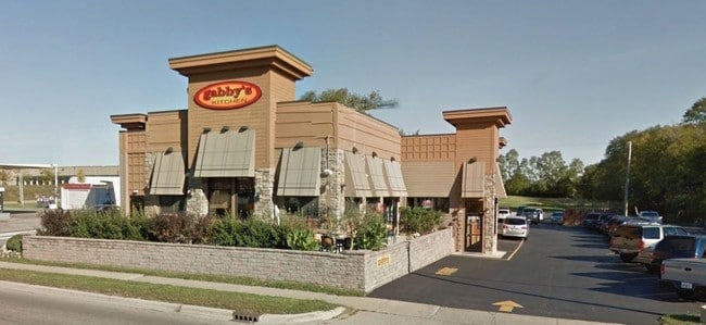
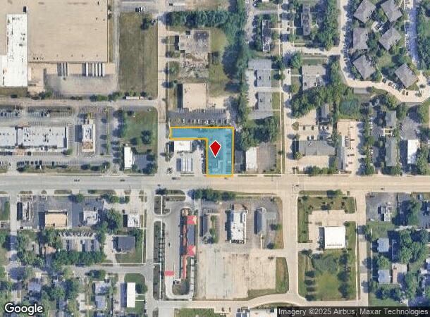
Property Record
1650 W Main St, Saint Charles, IL 60174
NEARBY LISTINGS FOR SALE OR LEASE
Property Detail
1650 W Main St
Chicago-Naperville-Elgin, IL-IN-WI
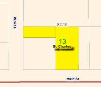
Wexi Sub
09-28-377-012
WEXI SUB UNIT 2 - THE SLY 50 FT OF THE WLY 150 FT OF LOT 3 & WEXI SUB UNIT 1 - THE WLY 106 FT OF LOT 2 COMBINED PER TAX PAYER REQUEST DATED 2/23/16
Commercialnec
Kane
X
Illinois
17089C0262H
3
2024
0.67 AC
2024
Western East/West Corr
852203
Chicago
DEMOGRAPHICS near 1650 W Main St
1 Mile
3 Mile
5 Mile
2024 Total Population
9,961
54,519
101,347
2029 Population
9,937
54,121
100,007
Pop Growth 2024-2029
(0.24%)
(0.73%)
(1.32%)
Average Age
41
42
42
2024 Total Households
4,155
21,171
37,689
HH Growth 2024-2029
(0.17%)
(0.71%)
(1.27%)
Median Household Inc
$86,333
$120,350
$127,075
Avg Household Size
2.30
2.50
2.60
2024 Avg HH Vehicles
2.00
2.00
2.00
Median Home Value
$344,678
$362,484
$378,002
Median Year Built
1979
1983
1988
Nearby Places
Map Layers
Map Styles
 Street
 Aerial
- Restaurants
- Banks
- Shops
- Fitness
- Groceries
PUBLIC TRANSPORTATION
COMMUTER RAIL
Geneva Station (Union Pacific West Line - Northeast Illinois Regional Commuter Railroad (Metra))
DRIVE
WALK
Distance
Geneva Station (Union Pacific West Line - Northeast Illinois Regional Commuter Railroad (Metra))
7 min
3.6 mi
La Fox Station (Union Pacific West Line - Northeast Illinois Regional Commuter Railroad (Metra))
DRIVE
WALK
Distance
La Fox Station (Union Pacific West Line - Northeast Illinois Regional Commuter Railroad (Metra))
12 min
6.6 mi
AIRPORT
Chicago O'Hare International
DRIVE
WALK
Distance
Chicago O'Hare International
53 min
38.2 mi
Freight Ports
Port Milwaukee
DRIVE
WALK
Distance
Port Milwaukee
131 min
94.5 mi
Nearby Properties
Address
Land Use
TOTAL SIZE
Lot Size
Zoning
Address
Land Use
TOTAL SIZE
Lot Size
Zoning
404,578 SF
40.29 AC
Address
Land Use
TOTAL SIZE
Lot Size
Zoning
5,482 SF
21.55 AC
Address
Land Use
TOTAL SIZE
Lot Size
Zoning
Address
Land Use
TOTAL SIZE
Lot Size
Zoning
217,340 SF
15.58 AC
Address
Land Use
TOTAL SIZE
Lot Size
Zoning
11.08 AC
Address
Land Use
TOTAL SIZE
Lot Size
Zoning
14,138 SF
7.56 AC
Address
Land Use
TOTAL SIZE
Lot Size
Zoning
86,704 SF
0.53 AC
Address
Land Use
TOTAL SIZE
Lot Size
Zoning
306,375 SF
23.82 AC
Address
Land Use
TOTAL SIZE
Lot Size
Zoning
170,986 SF
15.25 AC
Address
Land Use
TOTAL SIZE
Lot Size
Zoning
136,208 SF
12.52 AC
Address
Land Use
TOTAL SIZE
Lot Size
Zoning
74,929 SF
6.08 AC
Address
Land Use
TOTAL SIZE
Lot Size
Zoning
Address
Land Use
TOTAL SIZE
Lot Size
Zoning
142,313 SF
15.17 AC
Address
Land Use
TOTAL SIZE
Lot Size
Zoning
4,500 SF
11 AC
Address
Land Use
TOTAL SIZE
Lot Size
Zoning
178,890 SF
34.20 AC
Address
Land Use
TOTAL SIZE
Lot Size
Zoning
36,199 SF
5.84 AC
Address
Land Use
TOTAL SIZE
Lot Size
Zoning
258,768 SF
28.43 AC
Address
Land Use
TOTAL SIZE
Lot Size
Zoning
Address
Land Use
TOTAL SIZE
Lot Size
Zoning
18,861 SF
135.23 AC
Address
Land Use
TOTAL SIZE
Lot Size
Zoning
3,614 SF
4.46 AC
Address
Land Use
TOTAL SIZE
Lot Size
Zoning
13.46 AC
Address
Land Use
TOTAL SIZE
Lot Size
Zoning
33,761 SF
2.82 AC
Address
Land Use
TOTAL SIZE
Lot Size
Zoning
Address
Land Use
TOTAL SIZE
Lot Size
Zoning
Address
Land Use
TOTAL SIZE
Lot Size
Zoning
Address
Land Use
TOTAL SIZE
Lot Size
Zoning
Address
Land Use
TOTAL SIZE
Lot Size
Zoning
Address
Land Use
TOTAL SIZE
Lot Size
Zoning
Address
Land Use
TOTAL SIZE
Lot Size
Zoning
3.53 AC
The World's #1 Commercial Real Estate Marketplace
Connect with us
© 2025 CoStar Group
The information above has been obtained from sources believed reliable. While we do not doubt its accuracy we have not verified it and make no guarantee, warranty or representation about it. It is your responsibility to independently confirm its accuracy and completeness. Any projections, opinions, assumptions, or estimates used are for example only and do not represent the current or future performance of the property. The value of this transaction to you depends on tax and other factors which should be evaluated by your tax, financial, and legal advisors. You and your advisors should conduct a careful, independent investigation of the property to determine to your satisfaction the suitability of the property for your needs.