Property Record
166 Prosperous Pl, Lexington, KY 40509
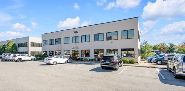

Property Detail
166 Prosperous Pl
Officecondo
G-534 EAGLE CREEK OFFICES LOT; BOOK: 130 PAGE: 451
P-1
Fayette
B and X Area of moderate flood hazard, usually the area between the limits of the 100-year and 500-year floods.
Kentucky
2025
East Lexington/Fayette
2025
Lexington/Fayette
003912
Lexington-Fayette, KY
2,280 SF
19345650
NEARBY LISTINGS FOR SALE OR LEASE
DEMOGRAPHICS near 166 Prosperous Pl
1 mile
3 mile
5 mile
2025 Total Population
13,883
92,151
205,444
2030 Population
14,407
95,063
212,053
Pop Growth 2025-2030
+ 3.77%
+ 3.16%
+ 3.22%
Average Age
37
39
38
2025 Total Households
6,497
39,894
89,069
HH Growth 2025-2030
+ 3.92%
+ 3.36%
+ 3.54%
Median Household Inc
$55,784
$72,601
$61,946
Avg Household Size
2.10
2.30
2.20
2025 Avg HH Vehicles
2.00
2.00
2.00
Median Home Value
$206,921
$329,764
$315,622
Median Year Built
1986
1988
1981
Nearby Places
Map Layers
Map Styles
 Street
 Aerial
Layers
 Traffic
 Biking
Places
Listings with unknown addresses are not visible on the map
- Restaurants
- Banks
- Shops
- Fitness
- Groceries
PUBLIC TRANSPORTATION
AIRPORT
Blue Grass
Drive
Walk
Distance
Blue Grass
25 min
14.7 mi
SALE & LEASE HISTORY
LISTING DATE
SALE/LEASE

Oct 23, 2022
For Lease
Nov 10, 2021
For Lease
Nov 04, 2022
For Lease
Feb 04, 2022
For Sale
Nearby Properties
Address
Land Use
TOTAL SIZE
Lot Size
Zoning
Address
Land Use
TOTAL SIZE
Lot Size
Zoning
163,323 SF
31 AC
P-1
Address
Land Use
TOTAL SIZE
Lot Size
Zoning
76,441 SF
63.86 AC
A-U
Address
Land Use
TOTAL SIZE
Lot Size
Zoning
301,644 SF
38.07 AC
R-1C
Address
Land Use
TOTAL SIZE
Lot Size
Zoning
7,640 SF
9.04 AC
EAR-3
Address
Land Use
TOTAL SIZE
Lot Size
Zoning
19 AC
R-3
Address
Land Use
TOTAL SIZE
Lot Size
Zoning
9,746 SF
16.65 AC
R-4
Address
Land Use
TOTAL SIZE
Lot Size
Zoning
18.69 AC
R-3
Address
Land Use
TOTAL SIZE
Lot Size
Zoning
64,617 SF
41.63 AC
B-6P
Address
Land Use
TOTAL SIZE
Lot Size
Zoning
8,208 SF
21.16 AC
R-3
Address
Land Use
TOTAL SIZE
Lot Size
Zoning
163,828 SF
17.69 AC
P-1
Address
Land Use
TOTAL SIZE
Lot Size
Zoning
57,974 SF
15.22 AC
B-6P
Address
Land Use
TOTAL SIZE
Lot Size
Zoning
24,174 SF
15.02 AC
R-3
Address
Land Use
TOTAL SIZE
Lot Size
Zoning
17.20 AC
R-4
Address
Land Use
TOTAL SIZE
Lot Size
Zoning
13.77 AC
R-4
Address
Land Use
TOTAL SIZE
Lot Size
Zoning
41.55 AC
ED
Address
Land Use
TOTAL SIZE
Lot Size
Zoning
5,815 SF
18.51 AC
EAR-2
Address
Land Use
TOTAL SIZE
Lot Size
Zoning
115,894 SF
58.52 AC
A-R
Address
Land Use
TOTAL SIZE
Lot Size
Zoning
42,642 SF
10.35 AC
B-6P
Address
Land Use
TOTAL SIZE
Lot Size
Zoning
4,868 SF
15.41 AC
R-3
Address
Land Use
TOTAL SIZE
Lot Size
Zoning
4,859 SF
20.45 AC
R-3
Address
Land Use
TOTAL SIZE
Lot Size
Zoning
9,434 SF
16.28 AC
R-3
Address
Land Use
TOTAL SIZE
Lot Size
Zoning
73,590 SF
13.31 AC
R-1T
Address
Land Use
TOTAL SIZE
Lot Size
Zoning
267,060 SF
65 AC
R-3
Address
Land Use
TOTAL SIZE
Lot Size
Zoning
4,406 SF
28.12 AC
R-3
Address
Land Use
TOTAL SIZE
Lot Size
Zoning
25,608 SF
104.39 AC
I-1
Address
Land Use
TOTAL SIZE
Lot Size
Zoning
53,543 SF
9.78 AC
R-1C
Address
Land Use
TOTAL SIZE
Lot Size
Zoning
123,132 SF
6.81 AC
R-4
Address
Land Use
TOTAL SIZE
Lot Size
Zoning
147,967 SF
17.03 AC
CC
Address
Land Use
TOTAL SIZE
Lot Size
Zoning
39,672 SF
46.50 AC
R-1B
Address
Land Use
TOTAL SIZE
Lot Size
Zoning
13,408 SF
9.95 AC
R-4
The World's #1 Commercial Real Estate Marketplace
Connect with us
© 2026 CoStar Group
The information above has been obtained from sources believed reliable. While we do not doubt its accuracy we have not verified it and make no guarantee, warranty or representation about it. It is your responsibility to independently confirm its accuracy and completeness. Any projections, opinions, assumptions, or estimates used are for example only and do not represent the current or future performance of the property. The value of this transaction to you depends on tax and other factors which should be evaluated by your tax, financial, and legal advisors. You and your advisors should conduct a careful, independent investigation of the property to determine to your satisfaction the suitability of the property for your needs.