Property Record
16630 Koala Rd, Adelanto, CA 92301


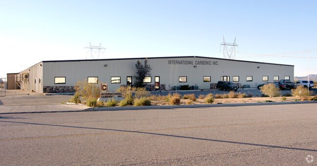
Property Detail
16630 Koala Rd
3129-261-57
PARCEL MAP 12345 PARCEL 8 BOOK 154 PAGE 29 PARCEL MAP 12345 PTN PARCEL 8 LYING NLY FOL DESC LI BEG AT A PT IN W LI SD PARCEL N 01 DEG 20 MIN 22 SECONDS E 488.67 FT FROM SW COR SD PARCEL TH S 88 DEG 39 MIN 38 SECONDS E 525.35 FT TO PT ON E LI SD PARCE
Lightindustrial
San Bernardino
C and X Area of minimal flood hazard, usually depicted on FIRMs as above the 500-year flood level.
California
2025
5 AC
2025
Mojave River Valley
009133
Inland Empire (California)
56,000 SF
Riverside-San Bernardino-Ontario, CA
NEARBY LISTINGS FOR SALE OR LEASE
DEMOGRAPHICS near 16630 Koala Rd
1 mile
3 mile
5 mile
2025 Total Population
81
16,593
50,652
2030 Population
84
16,958
51,619
Pop Growth 2025-2030
+ 3.70%
+ 2.20%
+ 1.91%
Average Age
34
33
34
2025 Total Households
18
4,133
11,796
HH Growth 2025-2030
+ 5.56%
+ 2.37%
+ 2.19%
Median Household Inc
$69,999
$70,819
$72,099
Avg Household Size
4.00
3.80
3.80
2025 Avg HH Vehicles
3.00
2.00
2.00
Median Home Value
$266,666
$328,950
$355,406
Median Year Built
2000
1998
1999
Nearby Places
Map Layers
Map Styles
 Street
 Aerial
Layers
 Traffic
 Biking
Places
Listings with unknown addresses are not visible on the map
- Restaurants
- Banks
- Shops
- Fitness
- Groceries
PUBLIC TRANSPORTATION
AIRPORT
Ontario International
Drive
Walk
Distance
Ontario International
65 min
49.1 mi
Nearby Properties
Address
Land Use
TOTAL SIZE
Lot Size
Zoning
Address
Land Use
TOTAL SIZE
Lot Size
Zoning
Address
Land Use
TOTAL SIZE
Lot Size
Zoning
306,258 SF
50.39 AC
Address
Land Use
TOTAL SIZE
Lot Size
Zoning
112,281 SF
6.78 AC
Address
Land Use
TOTAL SIZE
Lot Size
Zoning
96,592 SF
8.59 AC
Address
Land Use
TOTAL SIZE
Lot Size
Zoning
71,284 SF
9.34 AC
Address
Land Use
TOTAL SIZE
Lot Size
Zoning
95,724 SF
4.69 AC
Address
Land Use
TOTAL SIZE
Lot Size
Zoning
107,546 SF
9.66 AC
Address
Land Use
TOTAL SIZE
Lot Size
Zoning
132,545 SF
6.97 AC
Address
Land Use
TOTAL SIZE
Lot Size
Zoning
47,883 SF
4.68 AC
Address
Land Use
TOTAL SIZE
Lot Size
Zoning
32,328 SF
4.56 AC
Address
Land Use
TOTAL SIZE
Lot Size
Zoning
48,050 SF
4.66 AC
Address
Land Use
TOTAL SIZE
Lot Size
Zoning
36,068 SF
80 AC
Address
Land Use
TOTAL SIZE
Lot Size
Zoning
56,637 SF
0.69 AC
Address
Land Use
TOTAL SIZE
Lot Size
Zoning
41,613 SF
0.69 AC
Address
Land Use
TOTAL SIZE
Lot Size
Zoning
40.26 AC
Address
Land Use
TOTAL SIZE
Lot Size
Zoning
47,540 SF
0.69 AC
Address
Land Use
TOTAL SIZE
Lot Size
Zoning
52,716 SF
0.69 AC
Address
Land Use
TOTAL SIZE
Lot Size
Zoning
48,393 SF
0.69 AC
Address
Land Use
TOTAL SIZE
Lot Size
Zoning
46,270 SF
0.69 AC
Address
Land Use
TOTAL SIZE
Lot Size
Zoning
29,925 SF
0.69 AC
Address
Land Use
TOTAL SIZE
Lot Size
Zoning
29,925 SF
0.69 AC
Address
Land Use
TOTAL SIZE
Lot Size
Zoning
81,298 SF
4.67 AC
Address
Land Use
TOTAL SIZE
Lot Size
Zoning
21,675 SF
5.41 AC
Address
Land Use
TOTAL SIZE
Lot Size
Zoning
93,125 SF
4.67 AC
Address
Land Use
TOTAL SIZE
Lot Size
Zoning
65,664 SF
4.69 AC
Address
Land Use
TOTAL SIZE
Lot Size
Zoning
48,000 SF
4.72 AC
Address
Land Use
TOTAL SIZE
Lot Size
Zoning
29,925 SF
0.69 AC
Address
Land Use
TOTAL SIZE
Lot Size
Zoning
31,639 SF
0.69 AC
Address
Land Use
TOTAL SIZE
Lot Size
Zoning
29,925 SF
0.69 AC
Address
Land Use
TOTAL SIZE
Lot Size
Zoning
33,229 SF
0.69 AC
The World's #1 Commercial Real Estate Marketplace
Connect with us
© 2026 CoStar Group
The information above has been obtained from sources believed reliable. While we do not doubt its accuracy we have not verified it and make no guarantee, warranty or representation about it. It is your responsibility to independently confirm its accuracy and completeness. Any projections, opinions, assumptions, or estimates used are for example only and do not represent the current or future performance of the property. The value of this transaction to you depends on tax and other factors which should be evaluated by your tax, financial, and legal advisors. You and your advisors should conduct a careful, independent investigation of the property to determine to your satisfaction the suitability of the property for your needs.