Property Record
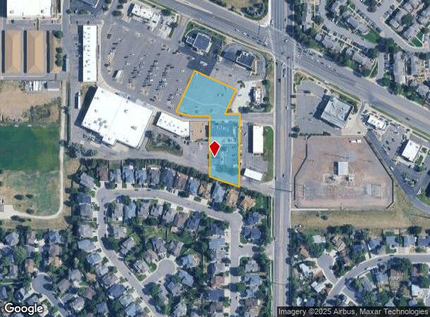
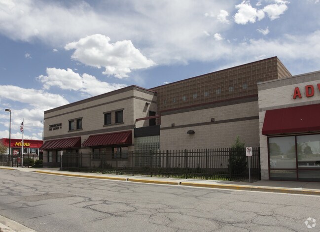
16758 E Smoky Hill Rd, Aurora, CO 80015

NEARBY LISTINGS FOR SALE OR LEASE
-
-
View all Aurora listings for sale on LoopNet.com
Property Detail
16758 E Smoky Hill Rd
Denver-Aurora-Lakewood, CO
Piney Creek Vrg Commercial Sub 3Rd Flg
2073-08-4-24-002
SUBDIVISIONCD 050117 SUBDIVISIONNAME PINEY CREEK VRG COMMERCIAL SUB 3RD FLG BLOCK 001 LOT 002 LOT 2 BLK 1 PINEY CREEK VRG COMMERCIAL SUB 3RD FLG
Recreationalentertainmentgeneral
Arapahoe
X
Colorado
08005C0193L
2
0
1.62 AC
2024
Aurora
081700
Denver
11,145 SF
DEMOGRAPHICS near 16758 E Smoky Hill Rd
1 Mile
3 Mile
5 Mile
2024 Total Population
16,515
120,437
288,629
2029 Population
16,359
119,867
289,784
Pop Growth 2024-2029
(0.94%)
(0.47%)
+ 0.40%
Average Age
39
39
39
2024 Total Households
5,687
42,088
105,164
HH Growth 2024-2029
(0.97%)
(0.52%)
+ 0.42%
Median Household Inc
$104,584
$102,578
$93,685
Avg Household Size
2.80
2.80
2.70
2024 Avg HH Vehicles
2.00
2.00
2.00
Median Home Value
$487,244
$457,204
$453,197
Median Year Built
1984
1988
1988
Nearby Places
Map Layers
Map Styles
 Street
 Aerial
- Restaurants
- Banks
- Shops
- Fitness
- Groceries
PUBLIC TRANSPORTATION
AIRPORT
Denver International
DRIVE
WALK
Distance
Denver International
32 min
25.3 mi
Freight Ports
Tulsa Port Of Catoosa
DRIVE
WALK
Distance
Tulsa Port Of Catoosa
725 min
705.2 mi
Nearby Properties
Address
Land Use
TOTAL SIZE
Lot Size
Zoning
Address
Land Use
TOTAL SIZE
Lot Size
Zoning
280,586 SF
60.97 AC
RPD
Address
Land Use
TOTAL SIZE
Lot Size
Zoning
134,316 SF
26.52 AC
Address
Land Use
TOTAL SIZE
Lot Size
Zoning
525,600 SF
57.90 AC
Address
Land Use
TOTAL SIZE
Lot Size
Zoning
217,273 SF
18.28 AC
Address
Land Use
TOTAL SIZE
Lot Size
Zoning
368,462 SF
11.68 AC
RZMF
Address
Land Use
TOTAL SIZE
Lot Size
Zoning
168,500 SF
24.03 AC
Address
Land Use
TOTAL SIZE
Lot Size
Zoning
12,726 SF
17.94 AC
Address
Land Use
TOTAL SIZE
Lot Size
Zoning
166,431 SF
19.37 AC
Address
Land Use
TOTAL SIZE
Lot Size
Zoning
122,965 SF
12.30 AC
RPD
Address
Land Use
TOTAL SIZE
Lot Size
Zoning
142,378 SF
14.64 AC
Address
Land Use
TOTAL SIZE
Lot Size
Zoning
106,000 SF
27.41 AC
Address
Land Use
TOTAL SIZE
Lot Size
Zoning
105,809 SF
48.79 AC
Address
Land Use
TOTAL SIZE
Lot Size
Zoning
383,969 SF
14.83 AC
AMU
Address
Land Use
TOTAL SIZE
Lot Size
Zoning
105,244 SF
12.64 AC
RPCZD
Address
Land Use
TOTAL SIZE
Lot Size
Zoning
14,600 SF
0.28 AC
WDC2A*
Address
Land Use
TOTAL SIZE
Lot Size
Zoning
176,000 SF
10.83 AC
PUD
Address
Land Use
TOTAL SIZE
Lot Size
Zoning
119,074 SF
9.38 AC
AMU
Address
Land Use
TOTAL SIZE
Lot Size
Zoning
206,064 SF
25.38 AC
AMU
Address
Land Use
TOTAL SIZE
Lot Size
Zoning
157,906 SF
14.47 AC
Address
Land Use
TOTAL SIZE
Lot Size
Zoning
344,071 SF
17.10 AC
Address
Land Use
TOTAL SIZE
Lot Size
Zoning
172,715 SF
4.23 AC
Address
Land Use
TOTAL SIZE
Lot Size
Zoning
117,267 SF
8.60 AC
PUD
Address
Land Use
TOTAL SIZE
Lot Size
Zoning
303,614 SF
15.49 AC
RR2
Address
Land Use
TOTAL SIZE
Lot Size
Zoning
114,838 SF
12.50 AC
Address
Land Use
TOTAL SIZE
Lot Size
Zoning
255,676 SF
13.97 AC
PUD
Address
Land Use
TOTAL SIZE
Lot Size
Zoning
140,000 SF
24.16 AC
AMU
Address
Land Use
TOTAL SIZE
Lot Size
Zoning
207,051 SF
9.77 AC
Address
Land Use
TOTAL SIZE
Lot Size
Zoning
84,662 SF
8.14 AC
PUD
Address
Land Use
TOTAL SIZE
Lot Size
Zoning
234,214 SF
5.23 AC
Address
Land Use
TOTAL SIZE
Lot Size
Zoning
96,480 SF
9.51 AC
PUD
The World's #1 Commercial Real Estate Marketplace
Connect with us
© 2025 CoStar Group
The information above has been obtained from sources believed reliable. While we do not doubt its accuracy we have not verified it and make no guarantee, warranty or representation about it. It is your responsibility to independently confirm its accuracy and completeness. Any projections, opinions, assumptions, or estimates used are for example only and do not represent the current or future performance of the property. The value of this transaction to you depends on tax and other factors which should be evaluated by your tax, financial, and legal advisors. You and your advisors should conduct a careful, independent investigation of the property to determine to your satisfaction the suitability of the property for your needs.