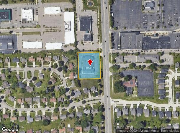
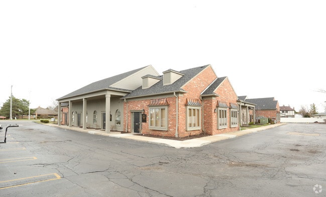
Property Record
16801 Newburgh Rd, Livonia, MI 48154

Current Lease Availabilities
NEARBY LISTINGS FOR SALE OR LEASE
Property Detail
16801 Newburgh Rd
Detroit-Warren-Dearborn, MI
Quakertown
46-069-99-0001-009
18A1A1A2 A1A1B1 PART OF NE 1/4 SEC 18 T1S R9E BEG S0DEG 21M 20S E 623.01FT AND S89DEG 58M W 60FT FROM NE COR OF SEC 18 TH S0DEG 21M 20S E 261FT TH S89DEG 58M W 220FT TH N0DEG 21M 20S W 261FT TH N89DEG 58M E 220FT POB 1.32 AC
Officebuilding
Wayne
X
Michigan
26163C0045E
0001
2025
1.32 AC
2025
Southern I-275 Corridor
557600
Detroit
14,900 SF
DEMOGRAPHICS near 16801 Newburgh Rd
1 Mile
3 Mile
5 Mile
2024 Total Population
9,148
57,256
198,079
2029 Population
8,747
54,953
191,439
Pop Growth 2024-2029
(4.38%)
(4.02%)
(3.35%)
Average Age
47
46
43
2024 Total Households
3,695
23,962
85,789
HH Growth 2024-2029
(4.28%)
(3.95%)
(3.32%)
Median Household Inc
$105,323
$102,662
$92,155
Avg Household Size
2.40
2.30
2.30
2024 Avg HH Vehicles
2.00
2.00
2.00
Median Home Value
$289,028
$305,906
$278,000
Median Year Built
1969
1974
1973
Nearby Places
Map Layers
Map Styles
 Street
 Aerial
- Restaurants
- Banks
- Shops
- Fitness
- Groceries
PUBLIC TRANSPORTATION
AIRPORT
Detroit Metro Wayne County
DRIVE
WALK
Distance
Detroit Metro Wayne County
31 min
22.2 mi
Windsor International
DRIVE
WALK
Distance
Windsor International
51 min
33.2 mi
Nearby Properties
Address
Land Use
TOTAL SIZE
Lot Size
Zoning
Address
Land Use
TOTAL SIZE
Lot Size
Zoning
3,733,882 SF
183.17 AC
M-2
Address
Land Use
TOTAL SIZE
Lot Size
Zoning
1,005,040 SF
Address
Land Use
TOTAL SIZE
Lot Size
Zoning
234,403 SF
74.21 AC
OS
Address
Land Use
TOTAL SIZE
Lot Size
Zoning
250,699 SF
16.89 AC
SH
Address
Land Use
TOTAL SIZE
Lot Size
Zoning
182,121 SF
10.85 AC
HPUD
Address
Land Use
TOTAL SIZE
Lot Size
Zoning
517,265 SF
116.72 AC
Address
Land Use
TOTAL SIZE
Lot Size
Zoning
102,878 SF
10.48 AC
CJ
Address
Land Use
TOTAL SIZE
Lot Size
Zoning
192,478 SF
IND
Address
Land Use
TOTAL SIZE
Lot Size
Zoning
289,722 SF
7.34 AC
C-2
Address
Land Use
TOTAL SIZE
Lot Size
Zoning
361,807 SF
18.77 AC
M-2
Address
Land Use
TOTAL SIZE
Lot Size
Zoning
199,485 SF
10.31 AC
R-9
Address
Land Use
TOTAL SIZE
Lot Size
Zoning
730,656 SF
13.73 AC
C-4
Address
Land Use
TOTAL SIZE
Lot Size
Zoning
206,496 SF
12.72 AC
PO
Address
Land Use
TOTAL SIZE
Lot Size
Zoning
283,710 SF
IND
Address
Land Use
TOTAL SIZE
Lot Size
Zoning
80,574 SF
19.95 AC
7MIPUD
Address
Land Use
TOTAL SIZE
Lot Size
Zoning
221,508 SF
26.03 AC
IND
Address
Land Use
TOTAL SIZE
Lot Size
Zoning
113,292 SF
15.79 AC
IND
Address
Land Use
TOTAL SIZE
Lot Size
Zoning
46.60 AC
R-3
Address
Land Use
TOTAL SIZE
Lot Size
Zoning
66,109 SF
35.02 AC
PO
Address
Land Use
TOTAL SIZE
Lot Size
Zoning
976 SF
26.85 AC
RM-1
Address
Land Use
TOTAL SIZE
Lot Size
Zoning
Address
Land Use
TOTAL SIZE
Lot Size
Zoning
172,094 SF
11.84 AC
M-2
Address
Land Use
TOTAL SIZE
Lot Size
Zoning
237,049 SF
27.23 AC
B-3
Address
Land Use
TOTAL SIZE
Lot Size
Zoning
19.68 AC
RM-1
Address
Land Use
TOTAL SIZE
Lot Size
Zoning
113,994 SF
6.32 AC
SH
Address
Land Use
TOTAL SIZE
Lot Size
Zoning
544,245 SF
22.30 AC
PO
Address
Land Use
TOTAL SIZE
Lot Size
Zoning
14,023 SF
17.32 AC
RM-1
Address
Land Use
TOTAL SIZE
Lot Size
Zoning
127,811 SF
6.95 AC
M-2
Address
Land Use
TOTAL SIZE
Lot Size
Zoning
145,232 SF
7.16 AC
M-2
Address
Land Use
TOTAL SIZE
Lot Size
Zoning
16.21 AC
R-7
The World's #1 Commercial Real Estate Marketplace
Connect with us
© 2026 CoStar Group
The information above has been obtained from sources believed reliable. While we do not doubt its accuracy we have not verified it and make no guarantee, warranty or representation about it. It is your responsibility to independently confirm its accuracy and completeness. Any projections, opinions, assumptions, or estimates used are for example only and do not represent the current or future performance of the property. The value of this transaction to you depends on tax and other factors which should be evaluated by your tax, financial, and legal advisors. You and your advisors should conduct a careful, independent investigation of the property to determine to your satisfaction the suitability of the property for your needs.