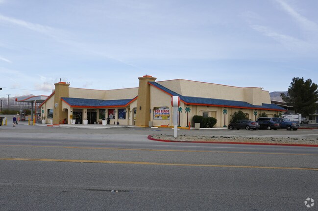
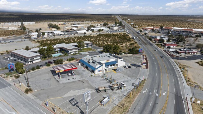
Property Record
16825 Highway 14, Mojave, CA 93501


Property Detail
16825 Highway 14
236-060-02-00-3
SECTION 8 , TOWNSHIP 11 , RANGE 12 , QUARTER
Commercialnec
KERN
C2
California
AO River or stream flood hazard areas, and areas with a 1% or greater chance of shallow flooding each year. These areas have a 26% chance of flooding over the life of a 30-year mortgage.
1.51 AC
2024
SE Outlying Kern County
2025
Bakersfield
005900
Bakersfield-Delano, CA
9,414 SF
NEARBY LISTINGS FOR SALE OR LEASE
DEMOGRAPHICS near 16825 Highway 14
1 mile
3 mile
5 mile
2025 Total Population
1,144
4,611
4,729
2030 Population
1,173
4,761
4,886
Pop Growth 2025-2030
+ 2.53%
+ 3.25%
+ 3.32%
Average Age
35
35
35
2025 Total Households
421
1,662
1,711
HH Growth 2025-2030
+ 2.61%
+ 3.25%
+ 3.33%
Median Household Inc
$57,142
$54,592
$54,921
Avg Household Size
2.70
2.70
2.70
2025 Avg HH Vehicles
2.00
2.00
2.00
Median Home Value
$217,969
$232,598
$237,735
Median Year Built
1980
1973
1975
Nearby Places
Map Layers
Map Styles
 Street
 Aerial
Layers
 Traffic
 Biking
Places
Listings with unknown addresses are not visible on the map
- Restaurants
- Banks
- Shops
- Fitness
- Groceries
SALE & LEASE HISTORY
LISTING DATE
SALE/LEASE

Oct 10, 2017
For Lease
Oct 09, 2019
For Sale
Nov 27, 2023
For Lease
Nearby Properties
Address
Land Use
TOTAL SIZE
Lot Size
Zoning
Address
Land Use
TOTAL SIZE
Lot Size
Zoning
1,500 SF
23.13 AC
M1
Address
Land Use
TOTAL SIZE
Lot Size
Zoning
405 SF
60 AC
M-3 PD FPS
Address
Land Use
TOTAL SIZE
Lot Size
Zoning
87,756 SF
6.03 AC
R2
Address
Land Use
TOTAL SIZE
Lot Size
Zoning
81.94 AC
R1
Address
Land Use
TOTAL SIZE
Lot Size
Zoning
0.86 AC
Address
Land Use
TOTAL SIZE
Lot Size
Zoning
31,198 SF
4.77 AC
C-2 PD FPS
Address
Land Use
TOTAL SIZE
Lot Size
Zoning
4,000 SF
47.96 AC
M-3 PD FPS
Address
Land Use
TOTAL SIZE
Lot Size
Zoning
31,652 SF
8.50 AC
C-2 PD FPS
Address
Land Use
TOTAL SIZE
Lot Size
Zoning
142.31 AC
M-3 PD FPS
Address
Land Use
TOTAL SIZE
Lot Size
Zoning
33,294 SF
2.63 AC
R-2 PD
Address
Land Use
TOTAL SIZE
Lot Size
Zoning
8,320 SF
0.87 AC
C2
Address
Land Use
TOTAL SIZE
Lot Size
Zoning
31,130 SF
2.85 AC
M2
Address
Land Use
TOTAL SIZE
Lot Size
Zoning
12,000 SF
0.69 AC
M-2 PD FPS
Address
Land Use
TOTAL SIZE
Lot Size
Zoning
2.73 AC
R-1 FPS
Address
Land Use
TOTAL SIZE
Lot Size
Zoning
19,120 SF
1.89 AC
M-2
Address
Land Use
TOTAL SIZE
Lot Size
Zoning
2,400 SF
1.03 AC
R-3 PD FPS
Address
Land Use
TOTAL SIZE
Lot Size
Zoning
10,351 SF
0.52 AC
C-2 PD H F
Address
Land Use
TOTAL SIZE
Lot Size
Zoning
1,257 SF
0.61 AC
C-2 PD H F
Address
Land Use
TOTAL SIZE
Lot Size
Zoning
9,956 SF
1.76 AC
M-2 PD FPS
Address
Land Use
TOTAL SIZE
Lot Size
Zoning
16,875 SF
1.30 AC
C-2 PD FPS
Address
Land Use
TOTAL SIZE
Lot Size
Zoning
7,256 SF
0.70 AC
C-2 PD H F
Address
Land Use
TOTAL SIZE
Lot Size
Zoning
22,120 SF
1.56 AC
M-1 PD H F
Address
Land Use
TOTAL SIZE
Lot Size
Zoning
375 SF
3.40 AC
C1
Address
Land Use
TOTAL SIZE
Lot Size
Zoning
2,752 SF
0.68 AC
C2
Address
Land Use
TOTAL SIZE
Lot Size
Zoning
2,800 SF
89.48 AC
M-3 PD FPS
Address
Land Use
TOTAL SIZE
Lot Size
Zoning
2,763 SF
0.69 AC
C2
Address
Land Use
TOTAL SIZE
Lot Size
Zoning
9,527 SF
0.43 AC
C-2 PD H F
Address
Land Use
TOTAL SIZE
Lot Size
Zoning
1.46 AC
M-1 PD H F
Address
Land Use
TOTAL SIZE
Lot Size
Zoning
0.52 AC
C-2 PD FPS
The World's #1 Commercial Real Estate Marketplace
Connect with us
© 2026 CoStar Group
The information above has been obtained from sources believed reliable. While we do not doubt its accuracy we have not verified it and make no guarantee, warranty or representation about it. It is your responsibility to independently confirm its accuracy and completeness. Any projections, opinions, assumptions, or estimates used are for example only and do not represent the current or future performance of the property. The value of this transaction to you depends on tax and other factors which should be evaluated by your tax, financial, and legal advisors. You and your advisors should conduct a careful, independent investigation of the property to determine to your satisfaction the suitability of the property for your needs.