Property Record
17 Polly Drummond Shpg Ctr, Newark, DE 19711


NEARBY LISTINGS FOR SALE OR LEASE
Property Detail
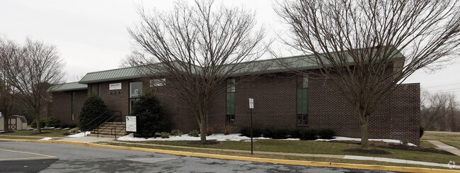
17 Polly Drummond Shpg Ctr
08-048.10-104
Neighborhood A Shop Ctr
Officebuilding
New Castle
X
Delaware
10003C0130L
0.67 AC
2024
West New Castle County
2024
Philadelphia
013611
Philadelphia-Camden-Wilmington, PA-NJ-DE-MD
12,648 SF
DEMOGRAPHICS near 17 Polly Drummond Shpg Ctr
1 mile
3 mile
5 mile
2024 Total Population
6,406
62,202
159,721
2029 Population
6,476
63,023
162,739
Pop Growth 2024-2029
+ 1.09%
+ 1.32%
+ 1.89%
Average Age
41
41
40
2024 Total Households
2,972
25,494
60,585
HH Growth 2024-2029
+ 1.14%
+ 1.38%
+ 1.99%
Median Household Inc
$68,386
$75,532
$79,689
Avg Household Size
2.10
2.30
2.40
2024 Avg HH Vehicles
2.00
2.00
2.00
Median Home Value
$278,885
$287,539
$299,654
Median Year Built
1979
1977
1976
Nearby Places
Map Layers
Map Styles
 Street
 Aerial
Transit
 Traffic
 Biking
Places
Listings with unknown addresses are not visible on the map
- Restaurants
- Banks
- Shops
- Fitness
- Groceries
PUBLIC TRANSPORTATION
AIRPORT
Philadelphia International
Drive
Walk
Distance
Philadelphia International
44 min
34.3 mi
SALE & LEASE HISTORY
LISTING DATE
SALE/LEASE

Apr 07, 2017
For Lease
Nearby Properties
Address
Land Use
TOTAL SIZE
Lot Size
Zoning
Address
Land Use
TOTAL SIZE
Lot Size
Zoning
25,000 SF
284.76 AC
CR
Address
Land Use
TOTAL SIZE
Lot Size
Zoning
118,400 SF
59.44 AC
S
Address
Land Use
TOTAL SIZE
Lot Size
Zoning
169,544 SF
60.86 AC
OR
Address
Land Use
TOTAL SIZE
Lot Size
Zoning
92,081 SF
30.99 AC
18RM
Address
Land Use
TOTAL SIZE
Lot Size
Zoning
Address
Land Use
TOTAL SIZE
Lot Size
Zoning
48,833 SF
33.06 AC
OR
Address
Land Use
TOTAL SIZE
Lot Size
Zoning
228,832 SF
19.38 AC
ST
Address
Land Use
TOTAL SIZE
Lot Size
Zoning
Address
Land Use
TOTAL SIZE
Lot Size
Zoning
43,943 SF
8.95 AC
18BB
Address
Land Use
TOTAL SIZE
Lot Size
Zoning
80,834 SF
4.60 AC
18BB
Address
Land Use
TOTAL SIZE
Lot Size
Zoning
7,146 SF
20 AC
S
Address
Land Use
TOTAL SIZE
Lot Size
Zoning
144,415 SF
19.53 AC
OR
Address
Land Use
TOTAL SIZE
Lot Size
Zoning
65,112 SF
30.74 AC
CR
Address
Land Use
TOTAL SIZE
Lot Size
Zoning
125,650 SF
39.91 AC
S
Address
Land Use
TOTAL SIZE
Lot Size
Zoning
194,234 SF
67.12 AC
S
Address
Land Use
TOTAL SIZE
Lot Size
Zoning
150,729 SF
1.60 AC
CR
Address
Land Use
TOTAL SIZE
Lot Size
Zoning
351,528 SF
24.88 AC
NCAP
Address
Land Use
TOTAL SIZE
Lot Size
Zoning
225,947 SF
18.68 AC
NCAP
Address
Land Use
TOTAL SIZE
Lot Size
Zoning
119,249 SF
11.36 AC
OR
Address
Land Use
TOTAL SIZE
Lot Size
Zoning
114,831 SF
6.87 AC
NC21
Address
Land Use
TOTAL SIZE
Lot Size
Zoning
306,266 SF
4.65 AC
CR
Address
Land Use
TOTAL SIZE
Lot Size
Zoning
332,800 SF
18.70 AC
NCAP
Address
Land Use
TOTAL SIZE
Lot Size
Zoning
22,211 SF
14.86 AC
ON
Address
Land Use
TOTAL SIZE
Lot Size
Zoning
3,004 SF
812.05 AC
SR
Address
Land Use
TOTAL SIZE
Lot Size
Zoning
Address
Land Use
TOTAL SIZE
Lot Size
Zoning
2,707 SF
116.94 AC
NCMM
Address
Land Use
TOTAL SIZE
Lot Size
Zoning
16,588 SF
72.24 AC
S
Address
Land Use
TOTAL SIZE
Lot Size
Zoning
133,661 SF
11.84 AC
18BB
Address
Land Use
TOTAL SIZE
Lot Size
Zoning
39,200 SF
7.88 AC
OR
Address
Land Use
TOTAL SIZE
Lot Size
Zoning
12,648 SF
15.20 AC
NC6.5
The World's #1 Commercial Real Estate Marketplace
Connect with us
© 2026 CoStar Group
The information above has been obtained from sources believed reliable. While we do not doubt its accuracy we have not verified it and make no guarantee, warranty or representation about it. It is your responsibility to independently confirm its accuracy and completeness. Any projections, opinions, assumptions, or estimates used are for example only and do not represent the current or future performance of the property. The value of this transaction to you depends on tax and other factors which should be evaluated by your tax, financial, and legal advisors. You and your advisors should conduct a careful, independent investigation of the property to determine to your satisfaction the suitability of the property for your needs.