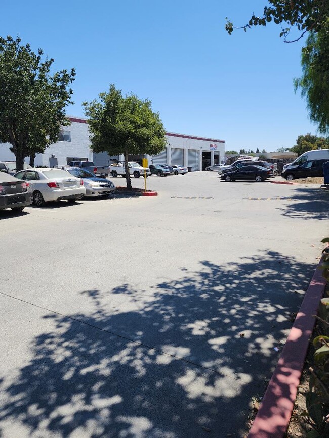
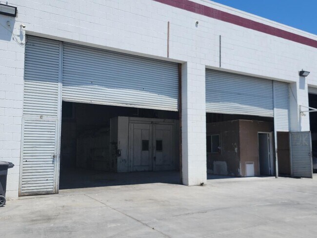
Property Record
170 Umbarger Rd, San Jose, CA 95111

Property Detail
170 Umbarger Rd
497-33-016
Santa Clara
Industrialgeneral
California
LI
5-n
D Areas with possible but undetermined flood hazards.
2.50 AC
2024
East San Jose-Willow Glen
2025
South Bay/San Jose
503222
San Jose-Sunnyvale-Santa Clara, CA
1,860 SF
NEARBY LISTINGS FOR SALE OR LEASE
DEMOGRAPHICS near 170 Umbarger Rd
1 mile
3 mile
5 mile
2025 Total Population
26,204
246,915
660,692
2030 Population
26,540
250,892
672,150
Pop Growth 2025-2030
+ 1.28%
+ 1.61%
+ 1.73%
Average Age
40
40
40
2025 Total Households
7,849
73,706
209,060
HH Growth 2025-2030
+ 1.48%
+ 1.70%
+ 1.91%
Median Household Inc
$98,030
$118,016
$123,869
Avg Household Size
3.20
3.20
3.00
2025 Avg HH Vehicles
2.00
2.00
2.00
Median Home Value
$630,654
$1,014,869
$1,061,974
Median Year Built
1987
1975
1974
Nearby Places
Map Layers
Map Styles
 Street
 Aerial
Layers
 Traffic
 Biking
Places
Listings with unknown addresses are not visible on the map
- Restaurants
- Banks
- Shops
- Fitness
- Groceries
PUBLIC TRANSPORTATION
COMMUTER RAIL
Drive
Walk
Distance
4 min
1.5 mi
Drive
Walk
Distance
7 min
2.9 mi
AIRPORT
Norman Y Mineta San Jose International
Drive
Walk
Distance
Norman Y Mineta San Jose International
15 min
8.3 mi
SALE & LEASE HISTORY
LISTING DATE
SALE/LEASE

Jul 22, 2025
For Lease
Nearby Properties
Address
Land Use
TOTAL SIZE
Lot Size
Zoning
Address
Land Use
TOTAL SIZE
Lot Size
Zoning
11.96 AC
M4
Address
Land Use
TOTAL SIZE
Lot Size
Zoning
1.16 AC
R1BD
Address
Land Use
TOTAL SIZE
Lot Size
Zoning
414,727 SF
16.59 AC
PD
Address
Land Use
TOTAL SIZE
Lot Size
Zoning
233,709 SF
3.87 AC
APD
Address
Land Use
TOTAL SIZE
Lot Size
Zoning
0.13 AC
R1B6
Address
Land Use
TOTAL SIZE
Lot Size
Zoning
241,800 SF
15.07 AC
R4
Address
Land Use
TOTAL SIZE
Lot Size
Zoning
243,344 SF
2 AC
C3
Address
Land Use
TOTAL SIZE
Lot Size
Zoning
209,128 SF
13.13 AC
R1PD
Address
Land Use
TOTAL SIZE
Lot Size
Zoning
279,086 SF
10.74 AC
R3
Address
Land Use
TOTAL SIZE
Lot Size
Zoning
5,000 SF
3.52 AC
CN
Address
Land Use
TOTAL SIZE
Lot Size
Zoning
8.72 AC
A-PD
Address
Land Use
TOTAL SIZE
Lot Size
Zoning
6.21 AC
APD
Address
Land Use
TOTAL SIZE
Lot Size
Zoning
358,320 SF
4.97 AC
R1-20
Address
Land Use
TOTAL SIZE
Lot Size
Zoning
155,286 SF
9.50 AC
R3
Address
Land Use
TOTAL SIZE
Lot Size
Zoning
120,816 SF
5.45 AC
C3PD
Address
Land Use
TOTAL SIZE
Lot Size
Zoning
6.24 AC
A-PD
Address
Land Use
TOTAL SIZE
Lot Size
Zoning
113.46 AC
M4
Address
Land Use
TOTAL SIZE
Lot Size
Zoning
21.67 AC
R3B
Address
Land Use
TOTAL SIZE
Lot Size
Zoning
255,590 SF
4.97 AC
A-PD
Address
Land Use
TOTAL SIZE
Lot Size
Zoning
163,904 SF
9.48 AC
R3APD
Address
Land Use
TOTAL SIZE
Lot Size
Zoning
5.05 AC
APD
Address
Land Use
TOTAL SIZE
Lot Size
Zoning
1.66 AC
APD
Address
Land Use
TOTAL SIZE
Lot Size
Zoning
549,100 SF
51.91 AC
CG
Address
Land Use
TOTAL SIZE
Lot Size
Zoning
151,200 SF
5.82 AC
APD
Address
Land Use
TOTAL SIZE
Lot Size
Zoning
189,598 SF
2.20 AC
APD
Address
Land Use
TOTAL SIZE
Lot Size
Zoning
10.42 AC
PD
Address
Land Use
TOTAL SIZE
Lot Size
Zoning
124,000 SF
13.12 AC
C1
Address
Land Use
TOTAL SIZE
Lot Size
Zoning
450,000 SF
13.53 AC
HI
Address
Land Use
TOTAL SIZE
Lot Size
Zoning
59,817 SF
2.18 AC
CP(PD
Address
Land Use
TOTAL SIZE
Lot Size
Zoning
46,440 SF
3.57 AC
R-1-8
The World's #1 Commercial Real Estate Marketplace
Connect with us
© 2026 CoStar Group
The information above has been obtained from sources believed reliable. While we do not doubt its accuracy we have not verified it and make no guarantee, warranty or representation about it. It is your responsibility to independently confirm its accuracy and completeness. Any projections, opinions, assumptions, or estimates used are for example only and do not represent the current or future performance of the property. The value of this transaction to you depends on tax and other factors which should be evaluated by your tax, financial, and legal advisors. You and your advisors should conduct a careful, independent investigation of the property to determine to your satisfaction the suitability of the property for your needs.