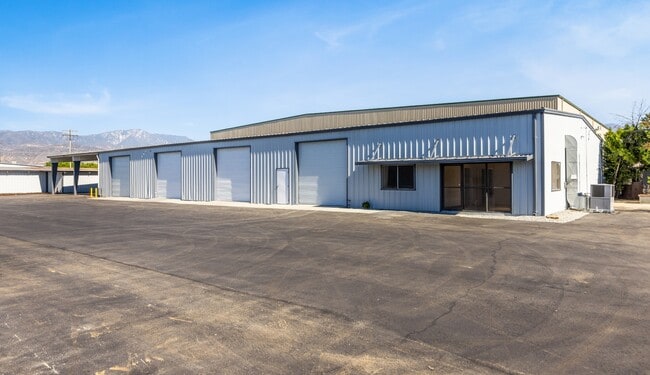
Property Record
1700 E Colton Ave, Redlands, CA 92374


Current Lease Availabilities
Property Detail
1700 E Colton Ave
Riverside-San Bernardino-Ontario, CA
JUDSONS SUB PTN LOT 2 BLK 1 COM AT SW COR LOT 2 ON E LI WABASH AVE TH E 430 FT TO TRUE POB TH N PARALLEL WITH W LI SD LOT 556.38 FT TO SLY LI SP RR R/W TH NELY ALG SD R/W TO E LI SD LOT TH S TO SE COR SD LOT TH W TO A PT 430 FT E OF E LI WABASH AVE T
0299-011-17
San Bernardino
Lightindustrial
California
IC
2
2025
2.27 AC
2025
Redlands/Loma Linda
008601
Inland Empire (California)
44,294 SF
NEARBY LISTINGS FOR SALE OR LEASE
DEMOGRAPHICS near 1700 E Colton Ave
1 mile
3 mile
5 mile
2025 Total Population
12,294
61,940
118,347
2030 Population
12,342
62,642
119,859
Pop Growth 2025-2030
+ 0.39%
+ 1.13%
+ 1.28%
Average Age
39
39
39
2025 Total Households
4,230
21,309
41,514
HH Growth 2025-2030
+ 0.38%
+ 1.23%
+ 1.35%
Median Household Inc
$109,493
$100,005
$106,597
Avg Household Size
2.80
2.80
2.70
2025 Avg HH Vehicles
2.00
2.00
2.00
Median Home Value
$561,862
$624,788
$648,869
Median Year Built
1981
1976
1981
Nearby Places
Map Layers
Map Styles
 Street
 Aerial
Layers
 Traffic
 Biking
Places
Listings with unknown addresses are not visible on the map
- Restaurants
- Banks
- Shops
- Fitness
- Groceries
PUBLIC TRANSPORTATION
COMMUTER RAIL
Redlands - University Metrolink Station (Metrolink San Bernardino Line - Metrolink Trains)
Drive
Walk
Distance
Redlands - University Metrolink Station (Metrolink San Bernardino Line - Metrolink Trains)
6 min
2.6 mi
Redlands - Downtown Metrolink Station (Metrolink San Bernardino Line - Metrolink Trains)
Drive
Walk
Distance
Redlands - Downtown Metrolink Station (Metrolink San Bernardino Line - Metrolink Trains)
8 min
3.0 mi
AIRPORT
Ontario International
Drive
Walk
Distance
Ontario International
37 min
28.0 mi
Freight Ports
Port of Long Beach
Drive
Walk
Distance
Port of Long Beach
95 min
73.4 mi
Nearby Properties
Address
Land Use
TOTAL SIZE
Lot Size
Zoning
Address
Land Use
TOTAL SIZE
Lot Size
Zoning
56.83 AC
Address
Land Use
TOTAL SIZE
Lot Size
Zoning
166,788 SF
11.74 AC
Address
Land Use
TOTAL SIZE
Lot Size
Zoning
169,312 SF
10.99 AC
Address
Land Use
TOTAL SIZE
Lot Size
Zoning
82,356 SF
5.10 AC
RM
Address
Land Use
TOTAL SIZE
Lot Size
Zoning
164,794 SF
1.32 AC
Address
Land Use
TOTAL SIZE
Lot Size
Zoning
104,067 SF
Address
Land Use
TOTAL SIZE
Lot Size
Zoning
80,673 SF
0.96 AC
Address
Land Use
TOTAL SIZE
Lot Size
Zoning
89,248 SF
4.75 AC
Address
Land Use
TOTAL SIZE
Lot Size
Zoning
123,230 SF
6.33 AC
CGSCP
Address
Land Use
TOTAL SIZE
Lot Size
Zoning
63,831 SF
4.07 AC
Address
Land Use
TOTAL SIZE
Lot Size
Zoning
61,094 SF
3.95 AC
Address
Land Use
TOTAL SIZE
Lot Size
Zoning
37.87 AC
RS
Address
Land Use
TOTAL SIZE
Lot Size
Zoning
31.34 AC
Address
Land Use
TOTAL SIZE
Lot Size
Zoning
17,278 SF
5.08 AC
Address
Land Use
TOTAL SIZE
Lot Size
Zoning
2,527 SF
35.13 AC
IC
Address
Land Use
TOTAL SIZE
Lot Size
Zoning
39,424 SF
3.07 AC
Z2
Address
Land Use
TOTAL SIZE
Lot Size
Zoning
47,280 SF
3.45 AC
Address
Land Use
TOTAL SIZE
Lot Size
Zoning
29,463 SF
0.28 AC
Address
Land Use
TOTAL SIZE
Lot Size
Zoning
54,148 SF
6.33 AC
Address
Land Use
TOTAL SIZE
Lot Size
Zoning
72,702 SF
4.57 AC
Address
Land Use
TOTAL SIZE
Lot Size
Zoning
38,616 SF
0.55 AC
Address
Land Use
TOTAL SIZE
Lot Size
Zoning
36,892 SF
2.30 AC
RM
Address
Land Use
TOTAL SIZE
Lot Size
Zoning
99,315 SF
2.53 AC
Address
Land Use
TOTAL SIZE
Lot Size
Zoning
41,000 SF
3.41 AC
Address
Land Use
TOTAL SIZE
Lot Size
Zoning
62,115 SF
13.20 AC
Address
Land Use
TOTAL SIZE
Lot Size
Zoning
15,162 SF
2.73 AC
Address
Land Use
TOTAL SIZE
Lot Size
Zoning
63,917 SF
6.61 AC
Address
Land Use
TOTAL SIZE
Lot Size
Zoning
43,250 SF
6.70 AC
Address
Land Use
TOTAL SIZE
Lot Size
Zoning
45,565 SF
4.48 AC
Address
Land Use
TOTAL SIZE
Lot Size
Zoning
63,972 SF
3.74 AC
The World's #1 Commercial Real Estate Marketplace
Connect with us
© 2026 CoStar Group
The information above has been obtained from sources believed reliable. While we do not doubt its accuracy we have not verified it and make no guarantee, warranty or representation about it. It is your responsibility to independently confirm its accuracy and completeness. Any projections, opinions, assumptions, or estimates used are for example only and do not represent the current or future performance of the property. The value of this transaction to you depends on tax and other factors which should be evaluated by your tax, financial, and legal advisors. You and your advisors should conduct a careful, independent investigation of the property to determine to your satisfaction the suitability of the property for your needs.