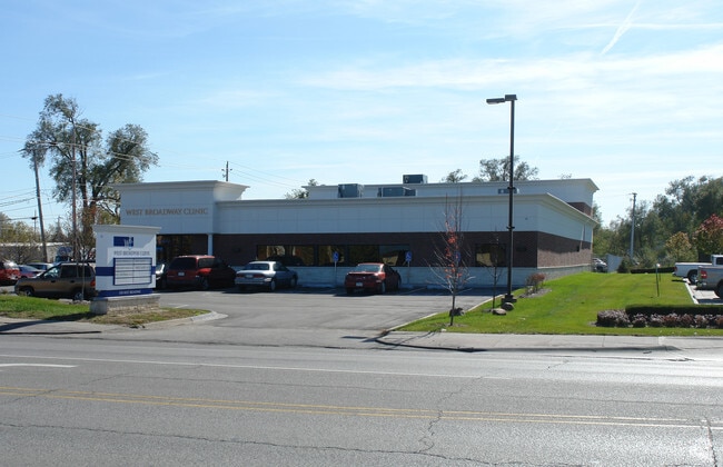
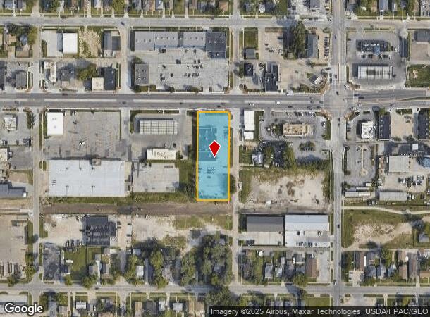
Property Record
1701 W Broadway, Council Bluffs, IA 51501

NEARBY LISTINGS FOR SALE OR LEASE
Property Detail
1701 W Broadway
Omaha-Council Bluffs, NE-IA
Goodmans Subdivision
7544-26-454-001
GOODMANS SUB LT 3 EXC PT IN NE COR TO CITY FOR ROW
Medicalbuilding
Pottawattamie
X
Iowa
31055C0275H
3
2025
1.12 AC
2025
Downtown Council Bluffs
030602
Omaha/Council Bluffs
13,595 SF
DEMOGRAPHICS near 1701 W Broadway
1 Mile
3 Mile
5 Mile
2024 Total Population
12,709
53,776
137,803
2029 Population
12,719
53,615
139,401
Pop Growth 2024-2029
+ 0.08%
(0.30%)
+ 1.16%
Average Age
40
40
37
2024 Total Households
5,186
21,655
54,784
HH Growth 2024-2029
+ 0.10%
(0.33%)
+ 1.35%
Median Household Inc
$49,619
$55,998
$51,528
Avg Household Size
2.30
2.30
2.30
2024 Avg HH Vehicles
2.00
2.00
2.00
Median Home Value
$116,889
$145,388
$161,875
Median Year Built
1948
1957
1959
Nearby Places
Map Layers
Map Styles
 Street
 Aerial
- Restaurants
- Banks
- Shops
- Fitness
- Groceries
PUBLIC TRANSPORTATION
COMMUTER RAIL
Omaha Amtrak Station (California Zephyr - Amtrak)
DRIVE
WALK
Distance
Omaha Amtrak Station (California Zephyr - Amtrak)
9 min
3.9 mi
Omaha Amtrak Station (California Zephyr - Amtrak)
DRIVE
WALK
Distance
Omaha Amtrak Station (California Zephyr - Amtrak)
10 min
4.2 mi
AIRPORT
Eppley Airfield
DRIVE
WALK
Distance
Eppley Airfield
17 min
6.8 mi
Freight Ports
Tulsa Port Of Catoosa
DRIVE
WALK
Distance
Tulsa Port Of Catoosa
460 min
415.7 mi
Nearby Properties
Address
Land Use
TOTAL SIZE
Lot Size
Zoning
Address
Land Use
TOTAL SIZE
Lot Size
Zoning
62.66 AC
P-C
Address
Land Use
TOTAL SIZE
Lot Size
Zoning
36.26 AC
P-C
Address
Land Use
TOTAL SIZE
Lot Size
Zoning
30.39 AC
P-C
Address
Land Use
TOTAL SIZE
Lot Size
Zoning
52.44 AC
I-2
Address
Land Use
TOTAL SIZE
Lot Size
Zoning
318,811 SF
11.51 AC
Address
Land Use
TOTAL SIZE
Lot Size
Zoning
16.18 AC
P-C
Address
Land Use
TOTAL SIZE
Lot Size
Zoning
50.56 AC
I-1
Address
Land Use
TOTAL SIZE
Lot Size
Zoning
318,392 SF
7.77 AC
Address
Land Use
TOTAL SIZE
Lot Size
Zoning
4.22 AC
R-4
Address
Land Use
TOTAL SIZE
Lot Size
Zoning
27.38 AC
I-2
Address
Land Use
TOTAL SIZE
Lot Size
Zoning
10.91 AC
R-3
Address
Land Use
TOTAL SIZE
Lot Size
Zoning
42.97 AC
I-2
Address
Land Use
TOTAL SIZE
Lot Size
Zoning
16.87 AC
P-C
Address
Land Use
TOTAL SIZE
Lot Size
Zoning
68.36 AC
R-1M
Address
Land Use
TOTAL SIZE
Lot Size
Zoning
98,202 SF
17.88 AC
P-C
Address
Land Use
TOTAL SIZE
Lot Size
Zoning
2.91 AC
A-P
Address
Land Use
TOTAL SIZE
Lot Size
Zoning
17.40 AC
A-P
Address
Land Use
TOTAL SIZE
Lot Size
Zoning
0.89 AC
P-C
Address
Land Use
TOTAL SIZE
Lot Size
Zoning
37.25 AC
I-2
Address
Land Use
TOTAL SIZE
Lot Size
Zoning
15.96 AC
I-2
Address
Land Use
TOTAL SIZE
Lot Size
Zoning
11.10 AC
R-3
Address
Land Use
TOTAL SIZE
Lot Size
Zoning
14 AC
I-2
Address
Land Use
TOTAL SIZE
Lot Size
Zoning
3,552 SF
18.50 AC
I-2
Address
Land Use
TOTAL SIZE
Lot Size
Zoning
30.64 AC
R-1
Address
Land Use
TOTAL SIZE
Lot Size
Zoning
174,726 SF
4.33 AC
Address
Land Use
TOTAL SIZE
Lot Size
Zoning
1.99 AC
C-3
Address
Land Use
TOTAL SIZE
Lot Size
Zoning
96,400 SF
1.85 AC
Address
Land Use
TOTAL SIZE
Lot Size
Zoning
21.72 AC
I-2
Address
Land Use
TOTAL SIZE
Lot Size
Zoning
14.54 AC
P-C
Address
Land Use
TOTAL SIZE
Lot Size
Zoning
21.91 AC
P-C
The World's #1 Commercial Real Estate Marketplace
Connect with us
© 2025 CoStar Group
The information above has been obtained from sources believed reliable. While we do not doubt its accuracy we have not verified it and make no guarantee, warranty or representation about it. It is your responsibility to independently confirm its accuracy and completeness. Any projections, opinions, assumptions, or estimates used are for example only and do not represent the current or future performance of the property. The value of this transaction to you depends on tax and other factors which should be evaluated by your tax, financial, and legal advisors. You and your advisors should conduct a careful, independent investigation of the property to determine to your satisfaction the suitability of the property for your needs.