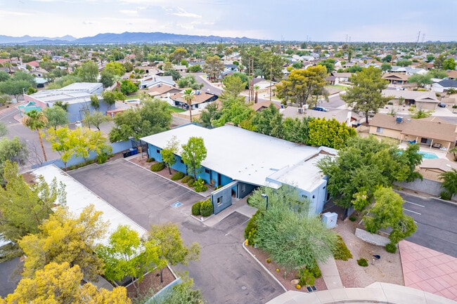
Property Record
1702 E Mcnair Dr, Tempe, AZ 85283

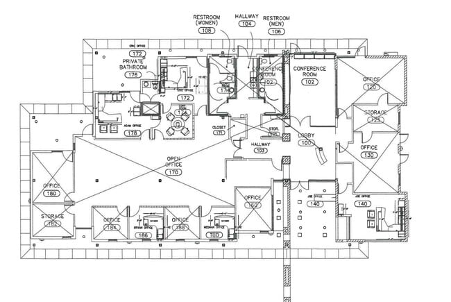
Current Lease Availabilities
Property Detail
1702 E Mcnair Dr
308-05-010
CROSSROADS OFFICE PARK LOT 1-18 MCR 306-28
Officebuilding
Maricopa
C-T
Arizona
C and X Area of minimal flood hazard, usually depicted on FIRMs as above the 500-year flood level.
10
2025
0.52 AC
2025
South Tempe/Ahwatukee
319905
Phoenix
4,999 SF
Phoenix-Mesa-Chandler, AZ
NEARBY LISTINGS FOR SALE OR LEASE
DEMOGRAPHICS near 1702 E Mcnair Dr
1 mile
3 mile
5 mile
2024 Total Population
11,820
124,441
370,521
2029 Population
12,106
127,760
381,752
Pop Growth 2024-2029
+ 2.42%
+ 2.67%
+ 3.03%
Average Age
43
39
37
2024 Total Households
4,809
49,571
151,050
HH Growth 2024-2029
+ 2.41%
+ 2.71%
+ 3.16%
Median Household Inc
$132,091
$103,133
$83,892
Avg Household Size
2.40
2.40
2.30
2024 Avg HH Vehicles
2.00
2.00
2.00
Median Home Value
$605,219
$482,418
$454,398
Median Year Built
1984
1983
1985
Nearby Places
Map Layers
Map Styles
 Street
 Aerial
Transit
 Traffic
 Biking
Places
Listings with unknown addresses are not visible on the map
- Restaurants
- Banks
- Shops
- Fitness
- Groceries
PUBLIC TRANSPORTATION
AIRPORT
Phoenix Sky Harbor International
Drive
Walk
Distance
Phoenix Sky Harbor International
20 min
11.8 mi
Phoenix-Mesa Gateway
Drive
Walk
Distance
Phoenix-Mesa Gateway
28 min
19.6 mi
Freight Ports
Port of San Diego
Drive
Walk
Distance
Port of San Diego
401 min
365.3 mi
Nearby Properties
Address
Land Use
TOTAL SIZE
Lot Size
Zoning
Address
Land Use
TOTAL SIZE
Lot Size
Zoning
136,458 SF
7.85 AC
PAD
Address
Land Use
TOTAL SIZE
Lot Size
Zoning
128,194 SF
8.58 AC
PAD
Address
Land Use
TOTAL SIZE
Lot Size
Zoning
1,418,890 SF
39 AC
PF
Address
Land Use
TOTAL SIZE
Lot Size
Zoning
14.98 AC
I-1
Address
Land Use
TOTAL SIZE
Lot Size
Zoning
860,343 SF
56.83 AC
I-1
Address
Land Use
TOTAL SIZE
Lot Size
Zoning
15,066 SF
2.54 AC
PAD
Address
Land Use
TOTAL SIZE
Lot Size
Zoning
607,734 SF
17.89 AC
AG
Address
Land Use
TOTAL SIZE
Lot Size
Zoning
442,642 SF
35.15 AC
GID
Address
Land Use
TOTAL SIZE
Lot Size
Zoning
393,258 SF
49.79 AC
AG
Address
Land Use
TOTAL SIZE
Lot Size
Zoning
415,228 SF
19.48 AC
I-1
Address
Land Use
TOTAL SIZE
Lot Size
Zoning
177,897 SF
17.81 AC
AG
Address
Land Use
TOTAL SIZE
Lot Size
Zoning
249,019 SF
23.96 AC
AG
Address
Land Use
TOTAL SIZE
Lot Size
Zoning
175,866 SF
12.46 AC
AG
Address
Land Use
TOTAL SIZE
Lot Size
Zoning
22,149 SF
6.33 AC
PAD
Address
Land Use
TOTAL SIZE
Lot Size
Zoning
244,900 SF
38.47 AC
PF
Address
Land Use
TOTAL SIZE
Lot Size
Zoning
428,895 SF
14.66 AC
PAD
Address
Land Use
TOTAL SIZE
Lot Size
Zoning
317,115 SF
36.47 AC
R-6
Address
Land Use
TOTAL SIZE
Lot Size
Zoning
387,347 SF
18.83 AC
M-H
Address
Land Use
TOTAL SIZE
Lot Size
Zoning
39,250 SF
119.46 AC
R1-6
Address
Land Use
TOTAL SIZE
Lot Size
Zoning
185,744 SF
36.64 AC
PF
Address
Land Use
TOTAL SIZE
Lot Size
Zoning
369,672 SF
22.28 AC
M-H
Address
Land Use
TOTAL SIZE
Lot Size
Zoning
36,180 SF
59.51 AC
AG
Address
Land Use
TOTAL SIZE
Lot Size
Zoning
154,689 SF
17.02 AC
AG
Address
Land Use
TOTAL SIZE
Lot Size
Zoning
236,706 SF
16.54 AC
I-1
Address
Land Use
TOTAL SIZE
Lot Size
Zoning
235,045 SF
10.09 AC
C-C
Address
Land Use
TOTAL SIZE
Lot Size
Zoning
154,157 SF
7.22 AC
I-1
Address
Land Use
TOTAL SIZE
Lot Size
Zoning
206,920 SF
26.79 AC
R-6
Address
Land Use
TOTAL SIZE
Lot Size
Zoning
435,648 SF
11.40 AC
PAD
Address
Land Use
TOTAL SIZE
Lot Size
Zoning
127,916 SF
13.64 AC
AG
Address
Land Use
TOTAL SIZE
Lot Size
Zoning
382,586 SF
21.50 AC
M-H
The World's #1 Commercial Real Estate Marketplace
Connect with us
© 2026 CoStar Group
The information above has been obtained from sources believed reliable. While we do not doubt its accuracy we have not verified it and make no guarantee, warranty or representation about it. It is your responsibility to independently confirm its accuracy and completeness. Any projections, opinions, assumptions, or estimates used are for example only and do not represent the current or future performance of the property. The value of this transaction to you depends on tax and other factors which should be evaluated by your tax, financial, and legal advisors. You and your advisors should conduct a careful, independent investigation of the property to determine to your satisfaction the suitability of the property for your needs.