Property Record
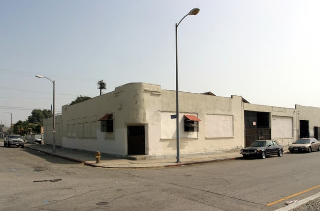
1710 E 57Th St, Los Angeles, CA 90058


Current Lease Availabilities
NEARBY LISTINGS FOR SALE OR LEASE
Property Detail
1710 E 57Th St
Los Angeles-Long Beach-Glendale, CA
Bowens Slauson Junction Tract
5105-021-029
BOWENS SLAUSON JUNCTION TRACT (EX OF ST) LOTS 222, 223 AND LOT 224
Lightindustrial
Los Angeles
X
California
06037C1805F
222
2024
0.30 AC
2025
South LA
228900
Los Angeles
9,827 SF
DEMOGRAPHICS near 1710 E 57Th St
1 Mile
3 Mile
5 Mile
2024 Total Population
40,044
378,022
1,123,737
2029 Population
37,709
358,218
1,076,942
Pop Growth 2024-2029
(5.83%)
(5.24%)
(4.16%)
Average Age
34
34
36
2024 Total Households
9,416
92,076
323,405
HH Growth 2024-2029
(6.37%)
(5.67%)
(4.09%)
Median Household Inc
$47,360
$49,000
$50,034
Avg Household Size
4.00
3.80
3.20
2024 Avg HH Vehicles
2.00
2.00
2.00
Median Home Value
$494,319
$553,432
$601,778
Median Year Built
1950
1950
1953
Nearby Places
Map Layers
Map Styles
 Street
 Aerial
- Restaurants
- Banks
- Shops
- Fitness
- Groceries
PUBLIC TRANSPORTATION
COMMUTER RAIL
DRIVE
WALK
Distance
12 min
4.7 mi
Union Station (91 Line - Southern California Regional Rail Authority (Metrolink), Antelope Valley Line - Southern California Regional Rail Authority (Metrolink), Orange County Line - Southern California Regional Rail Authority (Metrolink), Riverside Line - Southern California Regional Rail Authority (Metrolink), San Bernardino Line - Southern California Regional Rail Authority (Metrolink), Ventura County Line - Southern California Regional Rail Authority (Metrolink))
DRIVE
WALK
Distance
Union Station (91 Line - Southern California Regional Rail Authority (Metrolink), Antelope Valley Line - Southern California Regional Rail Authority (Metrolink), Orange County Line - Southern California Regional Rail Authority (Metrolink), Riverside Line - Southern California Regional Rail Authority (Metrolink), San Bernardino Line - Southern California Regional Rail Authority (Metrolink), Ventura County Line - Southern California Regional Rail Authority (Metrolink))
14 min
5.1 mi
AIRPORT
Los Angeles International
DRIVE
WALK
Distance
Los Angeles International
25 min
15.4 mi
Long Beach (Daugherty Field)
DRIVE
WALK
Distance
Long Beach (Daugherty Field)
28 min
17.1 mi
Bob Hope
DRIVE
WALK
Distance
Bob Hope
33 min
21.8 mi
Freight Ports
Port of Long Beach
DRIVE
WALK
Distance
Port of Long Beach
31 min
19.0 mi
Nearby Properties
Address
Land Use
TOTAL SIZE
Lot Size
Zoning
Address
Land Use
TOTAL SIZE
Lot Size
Zoning
2,697,158 SF
20.18 AC
LAM2
Address
Land Use
TOTAL SIZE
Lot Size
Zoning
256,059 SF
Address
Land Use
TOTAL SIZE
Lot Size
Zoning
298,630 SF
4.64 AC
LAUSC-1B
Address
Land Use
TOTAL SIZE
Lot Size
Zoning
1,088,170 SF
15.98 AC
LAM3
Address
Land Use
TOTAL SIZE
Lot Size
Zoning
227,179 SF
10.46 AC
VEM*
Address
Land Use
TOTAL SIZE
Lot Size
Zoning
284,335 SF
2.01 AC
LAM1
Address
Land Use
TOTAL SIZE
Lot Size
Zoning
326,472 SF
14.53 AC
VEM*
Address
Land Use
TOTAL SIZE
Lot Size
Zoning
188,319 SF
11.25 AC
VEM&MS1*
Address
Land Use
TOTAL SIZE
Lot Size
Zoning
108,598 SF
15.93 AC
LCC3*
Address
Land Use
TOTAL SIZE
Lot Size
Zoning
Address
Land Use
TOTAL SIZE
Lot Size
Zoning
95,639 SF
0.53 AC
LAC2
Address
Land Use
TOTAL SIZE
Lot Size
Zoning
116,827 SF
0.64 AC
LAC2
Address
Land Use
TOTAL SIZE
Lot Size
Zoning
251,338 SF
10.62 AC
LAM3
Address
Land Use
TOTAL SIZE
Lot Size
Zoning
330,904 SF
12.09 AC
VEM*
Address
Land Use
TOTAL SIZE
Lot Size
Zoning
7.02 AC
LAM3
Address
Land Use
TOTAL SIZE
Lot Size
Zoning
116,728 SF
0.86 AC
HPCP*
Address
Land Use
TOTAL SIZE
Lot Size
Zoning
372,634 SF
10.83 AC
VEM*
Address
Land Use
TOTAL SIZE
Lot Size
Zoning
369,554 SF
8.49 AC
VEM*
Address
Land Use
TOTAL SIZE
Lot Size
Zoning
234,264 SF
19.41 AC
LAM2
Address
Land Use
TOTAL SIZE
Lot Size
Zoning
564,529 SF
2.67 AC
LAUSC-1B
Address
Land Use
TOTAL SIZE
Lot Size
Zoning
261,540 SF
10.85 AC
VEM*
Address
Land Use
TOTAL SIZE
Lot Size
Zoning
100,515 SF
7.45 AC
VEM&MS1*
Address
Land Use
TOTAL SIZE
Lot Size
Zoning
386,865 SF
6 AC
VEM*
Address
Land Use
TOTAL SIZE
Lot Size
Zoning
108,641 SF
5.34 AC
VEM*
Address
Land Use
TOTAL SIZE
Lot Size
Zoning
353,151 SF
8.28 AC
VEM*
Address
Land Use
TOTAL SIZE
Lot Size
Zoning
150,790 SF
0.74 AC
LAC2
Address
Land Use
TOTAL SIZE
Lot Size
Zoning
289,913 SF
8.25 AC
VEM*
Address
Land Use
TOTAL SIZE
Lot Size
Zoning
261,502 SF
0.84 AC
LACM
Address
Land Use
TOTAL SIZE
Lot Size
Zoning
726,275 SF
14.41 AC
VEM*
Address
Land Use
TOTAL SIZE
Lot Size
Zoning
149,846 SF
5.85 AC
VEM*
The World's #1 Commercial Real Estate Marketplace
Connect with us
© 2025 CoStar Group
The information above has been obtained from sources believed reliable. While we do not doubt its accuracy we have not verified it and make no guarantee, warranty or representation about it. It is your responsibility to independently confirm its accuracy and completeness. Any projections, opinions, assumptions, or estimates used are for example only and do not represent the current or future performance of the property. The value of this transaction to you depends on tax and other factors which should be evaluated by your tax, financial, and legal advisors. You and your advisors should conduct a careful, independent investigation of the property to determine to your satisfaction the suitability of the property for your needs.