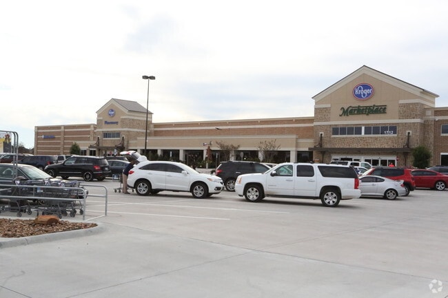
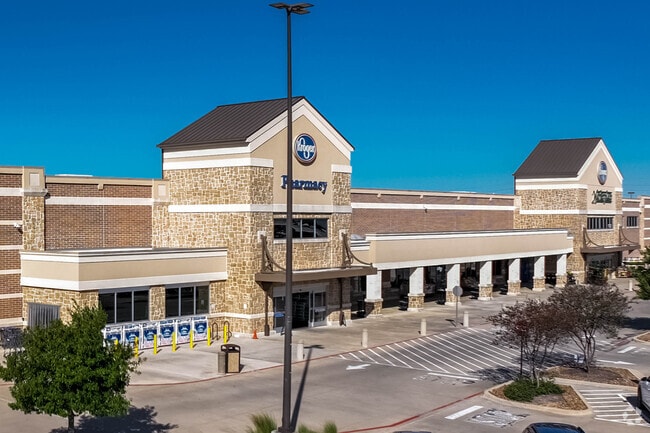
Property Record
1712 Spring Green Blvd, Katy, TX 77494

Save to a Folder
{{folder.Name}}
{{folder.ListingIds.length}} Properties
{{folder.ListingIds.length}} Property
Create a New Folder
Property Detail
1712 Spring Green Blvd
0157-01-001-0022-914
0157 JAS CONNER, ACRES 13.7832, SHOPS AT THE RESERVE REPLAT NO 1 RESERVE B PART (COMMERCIAL)
Commercialnec
FORT BEND
B and X Area of moderate flood hazard, usually the area between the limits of the 100-year and 500-year floods.
Texas
2024
13.78 AC
2025
Far Katy South
673109
Houston
123,917 SF
Houston-Pasadena-The Woodlands, TX
NEARBY LISTINGS FOR SALE OR LEASE
DEMOGRAPHICS near 1712 Spring Green Blvd
1 mile
3 mile
5 mile
2025 Total Population
8,950
82,707
224,568
2030 Population
10,259
94,259
252,873
Pop Growth 2025-2030
+ 14.63%
+ 13.97%
+ 12.60%
Average Age
36
35
36
2025 Total Households
2,765
25,028
70,766
HH Growth 2025-2030
+ 15.08%
+ 14.38%
+ 12.88%
Median Household Inc
$167,121
$155,152
$133,752
Avg Household Size
3.20
3.30
3.20
2025 Avg HH Vehicles
2.00
2.00
2.00
Median Home Value
$675,692
$543,277
$458,748
Median Year Built
2011
2011
2010
Nearby Places
Map Layers
Map Styles
 Street
 Aerial
Layers
 Traffic
 Biking
Places
Listings with unknown addresses are not visible on the map
- Restaurants
- Banks
- Shops
- Fitness
- Groceries
PUBLIC TRANSPORTATION
AIRPORT
William P Hobby
Drive
Walk
Distance
William P Hobby
62 min
43.2 mi
George Bush Intcntl/Houston
Drive
Walk
Distance
George Bush Intcntl/Houston
56 min
44.5 mi
Freight Ports
Port of Houston
Drive
Walk
Distance
Port of Houston
55 min
40.0 mi
Nearby Properties
Address
Land Use
TOTAL SIZE
Lot Size
Zoning
Address
Land Use
TOTAL SIZE
Lot Size
Zoning
39.24 AC
Address
Land Use
TOTAL SIZE
Lot Size
Zoning
1,655,920 SF
121.35 AC
Address
Land Use
TOTAL SIZE
Lot Size
Zoning
720,217 SF
65.17 AC
Address
Land Use
TOTAL SIZE
Lot Size
Zoning
610,000 SF
99.39 AC
Y
Address
Land Use
TOTAL SIZE
Lot Size
Zoning
350,883 SF
29.41 AC
Address
Land Use
TOTAL SIZE
Lot Size
Zoning
1,300,000 SF
60.33 AC
Address
Land Use
TOTAL SIZE
Lot Size
Zoning
185,815 SF
30.28 AC
Address
Land Use
TOTAL SIZE
Lot Size
Zoning
21.54 AC
Address
Land Use
TOTAL SIZE
Lot Size
Zoning
Address
Land Use
TOTAL SIZE
Lot Size
Zoning
15.87 AC
Address
Land Use
TOTAL SIZE
Lot Size
Zoning
6.13 AC
Address
Land Use
TOTAL SIZE
Lot Size
Zoning
16.46 AC
Address
Land Use
TOTAL SIZE
Lot Size
Zoning
12.50 AC
Address
Land Use
TOTAL SIZE
Lot Size
Zoning
261,803 SF
12.51 AC
Address
Land Use
TOTAL SIZE
Lot Size
Zoning
Address
Land Use
TOTAL SIZE
Lot Size
Zoning
329,094 SF
13.78 AC
Address
Land Use
TOTAL SIZE
Lot Size
Zoning
174,906 SF
31.18 AC
Address
Land Use
TOTAL SIZE
Lot Size
Zoning
678,028 SF
42.63 AC
Address
Land Use
TOTAL SIZE
Lot Size
Zoning
Address
Land Use
TOTAL SIZE
Lot Size
Zoning
148,600 SF
14.61 AC
Address
Land Use
TOTAL SIZE
Lot Size
Zoning
29.37 AC
Address
Land Use
TOTAL SIZE
Lot Size
Zoning
20.05 AC
SYQ
Address
Land Use
TOTAL SIZE
Lot Size
Zoning
296,130 SF
12 AC
Address
Land Use
TOTAL SIZE
Lot Size
Zoning
71.96 AC
Address
Land Use
TOTAL SIZE
Lot Size
Zoning
51,600 SF
19.66 AC
Address
Land Use
TOTAL SIZE
Lot Size
Zoning
108,600 SF
9.08 AC
Address
Land Use
TOTAL SIZE
Lot Size
Zoning
510,614 SF
56.19 AC
Address
Land Use
TOTAL SIZE
Lot Size
Zoning
117,000 SF
13.77 AC
Address
Land Use
TOTAL SIZE
Lot Size
Zoning
12.71 AC
Address
Land Use
TOTAL SIZE
Lot Size
Zoning
13.39 AC
The World's #1 Commercial Real Estate Marketplace
Connect with us
© 2026 CoStar Group
The information above has been obtained from sources believed reliable. While we do not doubt its accuracy we have not verified it and make no guarantee, warranty or representation about it. It is your responsibility to independently confirm its accuracy and completeness. Any projections, opinions, assumptions, or estimates used are for example only and do not represent the current or future performance of the property. The value of this transaction to you depends on tax and other factors which should be evaluated by your tax, financial, and legal advisors. You and your advisors should conduct a careful, independent investigation of the property to determine to your satisfaction the suitability of the property for your needs.