Property Record
1717 Freestone Flat Rd, Sebastopol, CA 95472

Save to a Folder
{{folder.Name}}
{{folder.ListingIds.length}} Properties
{{folder.ListingIds.length}} Property
Create a New Folder
Property Detail
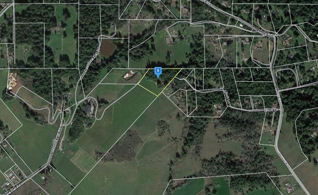
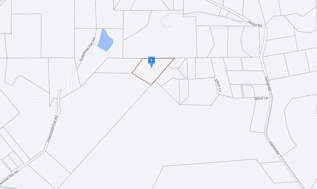
1717 Freestone Flat Rd
Santa Rosa-Petaluma, CA
2001 FM PT 073-100-072 00R089571 LLA 99-0043
073-100-082
SONOMA
Residentialacreage
California
B and X Area of moderate flood hazard, usually the area between the limits of the 100-year and 500-year floods.
6.40 AC
2025
Sebastopol/Bodega/West
2025
North Bay/Santa Rosa
154306
NEARBY LISTINGS FOR SALE OR LEASE
-
-
View all Sebastopol listings for sale on LoopNet.com
DEMOGRAPHICS near 1717 Freestone Flat Rd
1 mile
3 mile
5 mile
2025 Total Population
413
4,005
17,988
2030 Population
376
3,665
17,067
Pop Growth 2025-2030
(8.96%)
(8.49%)
(5.12%)
Average Age
51
51
49
2025 Total Households
170
1,636
7,544
HH Growth 2025-2030
(8.82%)
(8.56%)
(5.08%)
Median Household Inc
$165,517
$151,555
$116,886
Avg Household Size
2.30
2.30
2.30
2025 Avg HH Vehicles
3.00
2.00
2.00
Median Home Value
$1,095,161
$1,071,212
$994,397
Median Year Built
1977
1973
1972
Nearby Places
Map Layers
Map Styles
 Street
 Aerial
Layers
 Traffic
 Biking
Places
Listings with unknown addresses are not visible on the map
- Restaurants
- Banks
- Shops
- Fitness
- Groceries
PUBLIC TRANSPORTATION
AIRPORT
Charles M Schulz - Sonoma County
Drive
Walk
Distance
Charles M Schulz - Sonoma County
38 min
19.0 mi
Freight Ports
Port of Richmond
Drive
Walk
Distance
Port of Richmond
83 min
56.7 mi
Nearby Properties
Address
Land Use
TOTAL SIZE
Lot Size
Zoning
Address
Land Use
TOTAL SIZE
Lot Size
Zoning
24,711 SF
55.04 AC
Address
Land Use
TOTAL SIZE
Lot Size
Zoning
1,898 SF
250.60 AC
RRDW100
Address
Land Use
TOTAL SIZE
Lot Size
Zoning
250.14 AC
Address
Land Use
TOTAL SIZE
Lot Size
Zoning
616 SF
71.56 AC
RRD100
Address
Land Use
TOTAL SIZE
Lot Size
Zoning
1,040 SF
55.57 AC
DA20
Address
Land Use
TOTAL SIZE
Lot Size
Zoning
3,398 SF
75 AC
LEA60
Address
Land Use
TOTAL SIZE
Lot Size
Zoning
2,796 SF
42.62 AC
DA10
Address
Land Use
TOTAL SIZE
Lot Size
Zoning
0.79 AC
Address
Land Use
TOTAL SIZE
Lot Size
Zoning
6,467 SF
1.36 AC
Address
Land Use
TOTAL SIZE
Lot Size
Zoning
1,008 SF
25.70 AC
DA20
Address
Land Use
TOTAL SIZE
Lot Size
Zoning
3,378 SF
61.84 AC
LEA160
Address
Land Use
TOTAL SIZE
Lot Size
Zoning
2,412 SF
10.55 AC
Address
Land Use
TOTAL SIZE
Lot Size
Zoning
1,584 SF
99.72 AC
Address
Land Use
TOTAL SIZE
Lot Size
Zoning
6,407 SF
23.18 AC
Address
Land Use
TOTAL SIZE
Lot Size
Zoning
96.22 AC
Address
Land Use
TOTAL SIZE
Lot Size
Zoning
2,160 SF
0.22 AC
Address
Land Use
TOTAL SIZE
Lot Size
Zoning
3,074 SF
16.41 AC
DA10
Address
Land Use
TOTAL SIZE
Lot Size
Zoning
4,388 SF
29.11 AC
Address
Land Use
TOTAL SIZE
Lot Size
Zoning
3,006 SF
21.66 AC
DA20
Address
Land Use
TOTAL SIZE
Lot Size
Zoning
6,808 SF
95.94 AC
Address
Land Use
TOTAL SIZE
Lot Size
Zoning
912 SF
70.79 AC
LEA60
Address
Land Use
TOTAL SIZE
Lot Size
Zoning
2,100 SF
188.20 AC
Address
Land Use
TOTAL SIZE
Lot Size
Zoning
3,930 SF
17.30 AC
DA20
Address
Land Use
TOTAL SIZE
Lot Size
Zoning
3,024 SF
7.33 AC
DA10
Address
Land Use
TOTAL SIZE
Lot Size
Zoning
1,216 SF
3.87 AC
Address
Land Use
TOTAL SIZE
Lot Size
Zoning
2,247 SF
5 AC
DA20
Address
Land Use
TOTAL SIZE
Lot Size
Zoning
2,064 SF
26.80 AC
AR10
Address
Land Use
TOTAL SIZE
Lot Size
Zoning
3,630 SF
7.18 AC
DA20
Address
Land Use
TOTAL SIZE
Lot Size
Zoning
5,709 SF
0.42 AC
Address
Land Use
TOTAL SIZE
Lot Size
Zoning
1,512 SF
28.20 AC
DA20
The World's #1 Commercial Real Estate Marketplace
Connect with us
© 2026 CoStar Group
The information above has been obtained from sources believed reliable. While we do not doubt its accuracy we have not verified it and make no guarantee, warranty or representation about it. It is your responsibility to independently confirm its accuracy and completeness. Any projections, opinions, assumptions, or estimates used are for example only and do not represent the current or future performance of the property. The value of this transaction to you depends on tax and other factors which should be evaluated by your tax, financial, and legal advisors. You and your advisors should conduct a careful, independent investigation of the property to determine to your satisfaction the suitability of the property for your needs.