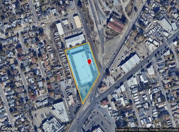
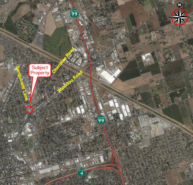
Property Record
1717 Sanguinetti Ln, Stockton, CA 95205


NEARBY LISTINGS FOR SALE OR LEASE
Property Detail
1717 Sanguinetti Ln
117-250-04
Weber Grant
Publicstorage
C M WEBER GRANT SEC 31
X
San Joaquin
06077C0460F
California
2025
2.87 AC
2025
NE Stockton
001502
Stockton/Modesto
8,265 SF
Stockton-Lodi, CA
DEMOGRAPHICS near 1717 Sanguinetti Ln
1 Mile
3 Mile
5 Mile
2024 Total Population
18,496
144,835
303,172
2029 Population
19,433
152,576
319,514
Pop Growth 2024-2029
+ 5.07%
+ 5.34%
+ 5.39%
Average Age
34
35
36
2024 Total Households
5,192
44,259
93,097
HH Growth 2024-2029
+ 5.05%
+ 5.53%
+ 5.49%
Median Household Inc
$55,936
$50,726
$61,132
Avg Household Size
3.40
3.10
3.10
2024 Avg HH Vehicles
2.00
2.00
2.00
Median Home Value
$224,515
$318,883
$347,088
Median Year Built
1956
1963
1972
Nearby Places
Map Layers
Map Styles
 Street
 Aerial
- Restaurants
- Banks
- Shops
- Fitness
- Groceries
PUBLIC TRANSPORTATION
COMMUTER RAIL
Stockton (ACE Train - Altamont Commuter Express (ACE), Altamont Corridor Express - Altamont Commuter Express (ACE))
DRIVE
WALK
Distance
Stockton (ACE Train - Altamont Commuter Express (ACE), Altamont Corridor Express - Altamont Commuter Express (ACE))
4 min
1.8 mi
Stockton (San Joaquins - Amtrak)
DRIVE
WALK
Distance
Stockton (San Joaquins - Amtrak)
5 min
2.8 mi
AIRPORT
Stockton Metro
DRIVE
WALK
Distance
Stockton Metro
12 min
6.5 mi
Freight Ports
Port of Stockton
DRIVE
WALK
Distance
Port of Stockton
10 min
5.4 mi
SALE & LEASE HISTORY
LISTING DATE
SALE/LEASE

Nov 21, 2016
For Lease
Jun 17, 2021
For Sale
Feb 05, 2020
For Sale
Nearby Properties
Address
Land Use
TOTAL SIZE
Lot Size
Zoning
Address
Land Use
TOTAL SIZE
Lot Size
Zoning
530,700 SF
8.35 AC
Address
Land Use
TOTAL SIZE
Lot Size
Zoning
30,080 SF
82.44 AC
Address
Land Use
TOTAL SIZE
Lot Size
Zoning
152,000 SF
1.31 AC
Address
Land Use
TOTAL SIZE
Lot Size
Zoning
4.78 AC
Address
Land Use
TOTAL SIZE
Lot Size
Zoning
10,208 SF
47.57 AC
Address
Land Use
TOTAL SIZE
Lot Size
Zoning
9,750 SF
136.94 AC
AU20
Address
Land Use
TOTAL SIZE
Lot Size
Zoning
502,000 SF
19.76 AC
Address
Land Use
TOTAL SIZE
Lot Size
Zoning
22.89 AC
Address
Land Use
TOTAL SIZE
Lot Size
Zoning
652,548 SF
35.24 AC
IL
Address
Land Use
TOTAL SIZE
Lot Size
Zoning
121,574 SF
5.49 AC
RHD
Address
Land Use
TOTAL SIZE
Lot Size
Zoning
47.61 AC
Address
Land Use
TOTAL SIZE
Lot Size
Zoning
82,512 SF
4.14 AC
Address
Land Use
TOTAL SIZE
Lot Size
Zoning
219,572 SF
16.53 AC
IL
Address
Land Use
TOTAL SIZE
Lot Size
Zoning
14,212 SF
26.11 AC
Address
Land Use
TOTAL SIZE
Lot Size
Zoning
15,203 SF
3.65 AC
Address
Land Use
TOTAL SIZE
Lot Size
Zoning
8,000 SF
0.67 AC
Address
Land Use
TOTAL SIZE
Lot Size
Zoning
62,588 SF
43.56 AC
IW
Address
Land Use
TOTAL SIZE
Lot Size
Zoning
0.79 AC
Address
Land Use
TOTAL SIZE
Lot Size
Zoning
37,846 SF
2.94 AC
Address
Land Use
TOTAL SIZE
Lot Size
Zoning
2.42 AC
Address
Land Use
TOTAL SIZE
Lot Size
Zoning
2,876 SF
10.54 AC
Address
Land Use
TOTAL SIZE
Lot Size
Zoning
67,195 SF
5.30 AC
Address
Land Use
TOTAL SIZE
Lot Size
Zoning
119,341 SF
7.98 AC
Address
Land Use
TOTAL SIZE
Lot Size
Zoning
95,838 SF
10.10 AC
Address
Land Use
TOTAL SIZE
Lot Size
Zoning
129,750 SF
8.63 AC
Address
Land Use
TOTAL SIZE
Lot Size
Zoning
261,860 SF
7.48 AC
IW
Address
Land Use
TOTAL SIZE
Lot Size
Zoning
84,895 SF
2.21 AC
Address
Land Use
TOTAL SIZE
Lot Size
Zoning
76,500 SF
7.03 AC
Address
Land Use
TOTAL SIZE
Lot Size
Zoning
65,516 SF
10.56 AC
RM
The World's #1 Commercial Real Estate Marketplace
Connect with us
© 2026 CoStar Group
The information above has been obtained from sources believed reliable. While we do not doubt its accuracy we have not verified it and make no guarantee, warranty or representation about it. It is your responsibility to independently confirm its accuracy and completeness. Any projections, opinions, assumptions, or estimates used are for example only and do not represent the current or future performance of the property. The value of this transaction to you depends on tax and other factors which should be evaluated by your tax, financial, and legal advisors. You and your advisors should conduct a careful, independent investigation of the property to determine to your satisfaction the suitability of the property for your needs.