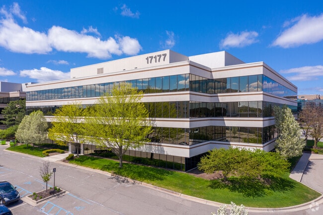
Property Record
17177 Laurel Dr, Livonia, MI 48152


Current Lease Availabilities
NEARBY LISTINGS FOR SALE OR LEASE
Property Detail
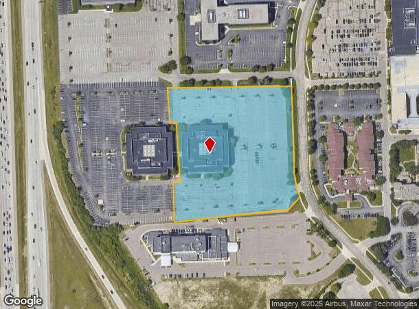
17177 Laurel Dr
46-028-99-0006-010
COMM AT THE SE COR OF SEC 7 T1S R9E CITY OF LIVONIA, WCR BEG S 89D 58M 00S W 2094.28 FT ALONG S LINE SEC TO ELY LINE OF I-275 TH N 30D 02M 00S W 738.82 FT TH N 22D 48M 30S W 14.87 FT TH N 87D 10M 01S E 321.11 FT TO POB TH CONT'D N 00D 02M 00S W 167.7
Officebuilding
Wayne
X
Michigan
26163C0045E
0006
2025
6.40 AC
2025
Southern I-275 Corridor
556700
Detroit
123,696 SF
Detroit-Warren-Dearborn, MI
DEMOGRAPHICS near 17177 Laurel Dr
1 Mile
3 Mile
5 Mile
2024 Total Population
6,585
64,042
194,900
2029 Population
6,335
61,706
188,609
Pop Growth 2024-2029
(3.80%)
(3.65%)
(3.23%)
Average Age
49
45
43
2024 Total Households
2,859
27,192
84,033
HH Growth 2024-2029
(3.57%)
(3.55%)
(3.19%)
Median Household Inc
$100,290
$103,244
$94,820
Avg Household Size
2.30
2.30
2.30
2024 Avg HH Vehicles
2.00
2.00
2.00
Median Home Value
$320,653
$310,862
$288,971
Median Year Built
1979
1977
1974
Nearby Places
Map Layers
Map Styles
 Street
 Aerial
- Restaurants
- Banks
- Shops
- Fitness
- Groceries
PUBLIC TRANSPORTATION
AIRPORT
Detroit Metro Wayne County
DRIVE
WALK
Distance
Detroit Metro Wayne County
21 min
20.8 mi
Detroit City
DRIVE
WALK
Distance
Detroit City
34 min
28.6 mi
Freight Ports
Port of Baltimore
DRIVE
WALK
Distance
Port of Baltimore
1 min
417.6 mi
Nearby Properties
Address
Land Use
TOTAL SIZE
Lot Size
Zoning
Address
Land Use
TOTAL SIZE
Lot Size
Zoning
1,005,040 SF
Address
Land Use
TOTAL SIZE
Lot Size
Zoning
234,403 SF
74.21 AC
OS
Address
Land Use
TOTAL SIZE
Lot Size
Zoning
250,699 SF
16.89 AC
SH
Address
Land Use
TOTAL SIZE
Lot Size
Zoning
182,121 SF
10.85 AC
HPUD
Address
Land Use
TOTAL SIZE
Lot Size
Zoning
517,265 SF
116.72 AC
Address
Land Use
TOTAL SIZE
Lot Size
Zoning
102,878 SF
10.48 AC
CJ
Address
Land Use
TOTAL SIZE
Lot Size
Zoning
192,478 SF
IND
Address
Land Use
TOTAL SIZE
Lot Size
Zoning
289,722 SF
7.34 AC
C-2
Address
Land Use
TOTAL SIZE
Lot Size
Zoning
334,346 SF
55.65 AC
TAR
Address
Land Use
TOTAL SIZE
Lot Size
Zoning
228,748 SF
25.06 AC
AI
Address
Land Use
TOTAL SIZE
Lot Size
Zoning
30.32 AC
RM-1
Address
Land Use
TOTAL SIZE
Lot Size
Zoning
214,242 SF
22.40 AC
AI
Address
Land Use
TOTAL SIZE
Lot Size
Zoning
361,807 SF
18.77 AC
M-2
Address
Land Use
TOTAL SIZE
Lot Size
Zoning
199,485 SF
10.31 AC
R-9
Address
Land Use
TOTAL SIZE
Lot Size
Zoning
730,656 SF
13.73 AC
C-4
Address
Land Use
TOTAL SIZE
Lot Size
Zoning
206,496 SF
12.72 AC
PO
Address
Land Use
TOTAL SIZE
Lot Size
Zoning
283,710 SF
IND
Address
Land Use
TOTAL SIZE
Lot Size
Zoning
80,574 SF
19.95 AC
7MIPUD
Address
Land Use
TOTAL SIZE
Lot Size
Zoning
9,706 SF
40.41 AC
RM-1
Address
Land Use
TOTAL SIZE
Lot Size
Zoning
221,508 SF
26.03 AC
IND
Address
Land Use
TOTAL SIZE
Lot Size
Zoning
113,292 SF
15.79 AC
IND
Address
Land Use
TOTAL SIZE
Lot Size
Zoning
129,448 SF
9.37 AC
OSC
Address
Land Use
TOTAL SIZE
Lot Size
Zoning
46.60 AC
R-3
Address
Land Use
TOTAL SIZE
Lot Size
Zoning
66,109 SF
35.02 AC
PO
Address
Land Use
TOTAL SIZE
Lot Size
Zoning
976 SF
26.85 AC
RM-1
Address
Land Use
TOTAL SIZE
Lot Size
Zoning
Address
Land Use
TOTAL SIZE
Lot Size
Zoning
16.54 AC
RM-1
Address
Land Use
TOTAL SIZE
Lot Size
Zoning
172,094 SF
11.84 AC
M-2
Address
Land Use
TOTAL SIZE
Lot Size
Zoning
237,049 SF
27.23 AC
B-3
Address
Land Use
TOTAL SIZE
Lot Size
Zoning
19.68 AC
RM-1
The World's #1 Commercial Real Estate Marketplace
Connect with us
© 2026 CoStar Group
The information above has been obtained from sources believed reliable. While we do not doubt its accuracy we have not verified it and make no guarantee, warranty or representation about it. It is your responsibility to independently confirm its accuracy and completeness. Any projections, opinions, assumptions, or estimates used are for example only and do not represent the current or future performance of the property. The value of this transaction to you depends on tax and other factors which should be evaluated by your tax, financial, and legal advisors. You and your advisors should conduct a careful, independent investigation of the property to determine to your satisfaction the suitability of the property for your needs.