Property Record
1718 Walnut St, Cary, NC 27511

NEARBY LISTINGS FOR SALE OR LEASE
Property Detail
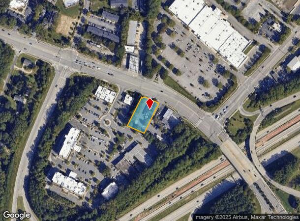
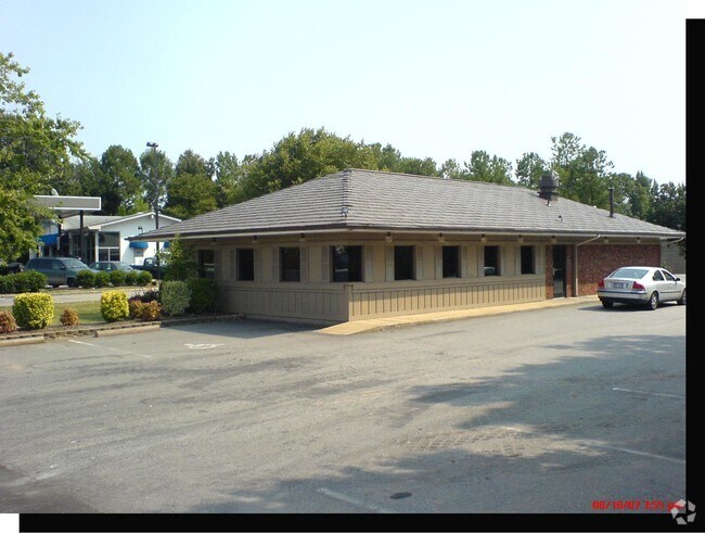
1718 Walnut St
0773.15-52-0736-000
1718 Walnut Street And 1722 Walnut Stree
Restaurantbuilding
RCMB 1718 & 1722 WALNUT STREET BM2003-01
X
Wake
3720077300K
North Carolina
2025
0.58 AC
2025
Cary
053505
Raleigh/Durham
2,139 SF
Raleigh-Cary, NC
DEMOGRAPHICS near 1718 Walnut St
1 mile
3 mile
5 mile
2024 Total Population
8,927
77,729
184,988
2029 Population
9,777
84,480
200,631
Pop Growth 2024-2029
+ 9.52%
+ 8.69%
+ 8.46%
Average Age
38
38
38
2024 Total Households
4,170
34,095
76,257
HH Growth 2024-2029
+ 9.69%
+ 8.79%
+ 8.75%
Median Household Inc
$79,333
$77,386
$81,939
Avg Household Size
2.10
2.20
2.30
2024 Avg HH Vehicles
2.00
2.00
2.00
Median Home Value
$340,754
$385,406
$415,569
Median Year Built
1990
1989
1991
Nearby Places
Map Layers
Map Styles
 Street
 Aerial
Transit
 Traffic
 Biking
Places
Listings with unknown addresses are not visible on the map
- Restaurants
- Banks
- Shops
- Fitness
- Groceries
PUBLIC TRANSPORTATION
COMMUTER RAIL
Cary Station (Piedmont - North Carolina by Train (NC Train))
Drive
Walk
Distance
Cary Station (Piedmont - North Carolina by Train (NC Train))
8 min
3.2 mi
Raleigh Union Station (Piedmont - North Carolina by Train (NC Train))
Drive
Walk
Distance
Raleigh Union Station (Piedmont - North Carolina by Train (NC Train))
11 min
6.8 mi
AIRPORT
Raleigh-Durham International
Drive
Walk
Distance
Raleigh-Durham International
19 min
11.9 mi
SALE & LEASE HISTORY
LISTING DATE
SALE/LEASE

Jul 18, 2018
For Sale
Nearby Properties
Address
Land Use
TOTAL SIZE
Lot Size
Zoning
Address
Land Use
TOTAL SIZE
Lot Size
Zoning
693,180 SF
17.61 AC
GCM
Address
Land Use
TOTAL SIZE
Lot Size
Zoning
633,930 SF
23.01 AC
OI
Address
Land Use
TOTAL SIZE
Lot Size
Zoning
439,439 SF
30.59 AC
OICU
Address
Land Use
TOTAL SIZE
Lot Size
Zoning
433,914 SF
11.81 AC
MXD
Address
Land Use
TOTAL SIZE
Lot Size
Zoning
441,502 SF
15.42 AC
OIM
Address
Land Use
TOTAL SIZE
Lot Size
Zoning
378,159 SF
22.40 AC
OX-7
Address
Land Use
TOTAL SIZE
Lot Size
Zoning
395,263 SF
6.07 AC
CX-5
Address
Land Use
TOTAL SIZE
Lot Size
Zoning
392,141 SF
24.49 AC
RMFM
Address
Land Use
TOTAL SIZE
Lot Size
Zoning
308,622 SF
14.34 AC
CX-5
Address
Land Use
TOTAL SIZE
Lot Size
Zoning
220,152 SF
67.76 AC
OIM
Address
Land Use
TOTAL SIZE
Lot Size
Zoning
402,447 SF
49.88 AC
GC
Address
Land Use
TOTAL SIZE
Lot Size
Zoning
359,022 SF
21.46 AC
OX-3
Address
Land Use
TOTAL SIZE
Lot Size
Zoning
211,387 SF
36.72 AC
OX-3
Address
Land Use
TOTAL SIZE
Lot Size
Zoning
435,090 SF
28.82 AC
RMFP
Address
Land Use
TOTAL SIZE
Lot Size
Zoning
357,293 SF
25.23 AC
RX-3
Address
Land Use
TOTAL SIZE
Lot Size
Zoning
387,626 SF
18.48 AC
RMFM
Address
Land Use
TOTAL SIZE
Lot Size
Zoning
382,324 SF
14.85 AC
OX-7
Address
Land Use
TOTAL SIZE
Lot Size
Zoning
341,943 SF
19.49 AC
RMFP
Address
Land Use
TOTAL SIZE
Lot Size
Zoning
290,022 SF
14.76 AC
RX-3
Address
Land Use
TOTAL SIZE
Lot Size
Zoning
314,623 SF
49.66 AC
R-10
Address
Land Use
TOTAL SIZE
Lot Size
Zoning
194,462 SF
21.62 AC
OICU
Address
Land Use
TOTAL SIZE
Lot Size
Zoning
330,232 SF
18.45 AC
OIP
Address
Land Use
TOTAL SIZE
Lot Size
Zoning
315,936 SF
20.45 AC
RX-3
Address
Land Use
TOTAL SIZE
Lot Size
Zoning
229,999 SF
7.83 AC
CX-3
Address
Land Use
TOTAL SIZE
Lot Size
Zoning
319,271 SF
38.96 AC
R12
Address
Land Use
TOTAL SIZE
Lot Size
Zoning
2,740 SF
400.73 AC
AP
Address
Land Use
TOTAL SIZE
Lot Size
Zoning
260,777 SF
22.54 AC
GCCU
Address
Land Use
TOTAL SIZE
Lot Size
Zoning
263,138 SF
25 AC
R-10
Address
Land Use
TOTAL SIZE
Lot Size
Zoning
285,176 SF
31.09 AC
RMF
Address
Land Use
TOTAL SIZE
Lot Size
Zoning
270,753 SF
20.56 AC
RMFP
The World's #1 Commercial Real Estate Marketplace
Connect with us
© 2026 CoStar Group
The information above has been obtained from sources believed reliable. While we do not doubt its accuracy we have not verified it and make no guarantee, warranty or representation about it. It is your responsibility to independently confirm its accuracy and completeness. Any projections, opinions, assumptions, or estimates used are for example only and do not represent the current or future performance of the property. The value of this transaction to you depends on tax and other factors which should be evaluated by your tax, financial, and legal advisors. You and your advisors should conduct a careful, independent investigation of the property to determine to your satisfaction the suitability of the property for your needs.