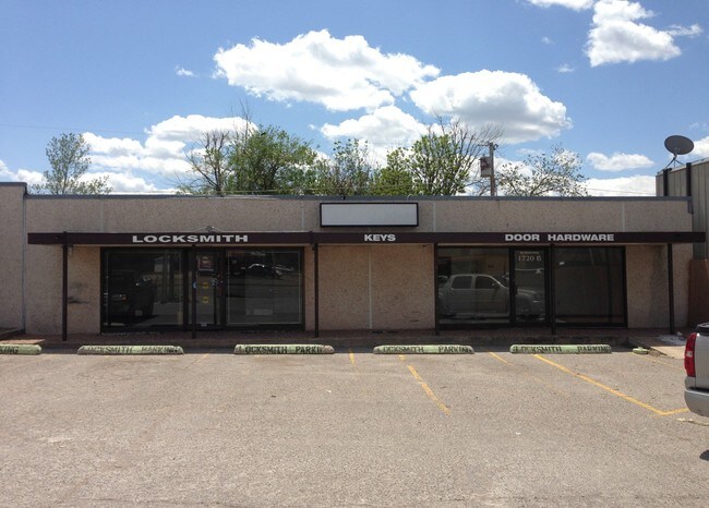
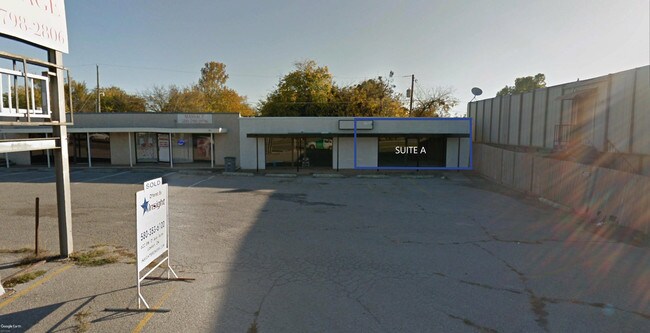
Property Record
1720 Nw Cache Rd, Lawton, OK 73507

Property Detail
1720 Nw Cache Rd
Lawton, OK
LIBERTY HEIGHTS BLK 1 LOT 10
160023770
COMANCHE
Storebuilding
Oklahoma
B and X Area of moderate flood hazard, usually the area between the limits of the 100-year and 500-year floods.
10
2025
0.15 AC
2025
Oklahoma West Area
000900
Other Market Areas
2,970 SF
NEARBY LISTINGS FOR SALE OR LEASE
DEMOGRAPHICS near 1720 Nw Cache Rd
1 mile
3 mile
5 mile
2025 Total Population
12,073
57,046
89,161
2030 Population
12,274
57,519
89,287
Pop Growth 2025-2030
+ 1.66%
+ 0.83%
+ 0.14%
Average Age
38
36
36
2025 Total Households
5,075
21,989
33,389
HH Growth 2025-2030
+ 1.54%
+ 0.91%
+ 0.16%
Median Household Inc
$45,344
$44,573
$52,383
Avg Household Size
2.30
2.30
2.40
2025 Avg HH Vehicles
1.00
1.00
2.00
Median Home Value
$91,047
$105,454
$142,150
Median Year Built
1958
1967
1974
Nearby Places
Map Layers
Map Styles
 Street
 Aerial
Layers
 Traffic
 Biking
Places
Listings with unknown addresses are not visible on the map
- Restaurants
- Banks
- Shops
- Fitness
- Groceries
PUBLIC TRANSPORTATION
AIRPORT
Lawton-Fort Sill Regional
Drive
Walk
Distance
Lawton-Fort Sill Regional
12 min
4.9 mi
SALE & LEASE HISTORY
LISTING DATE
SALE/LEASE

Sep 24, 2016
For Sale
Nov 07, 2016
For Lease
Nov 07, 2016
For Sale
Mar 14, 2019
For Lease
Jan 13, 2017
For Sale
Apr 13, 2017
For Sale
Nearby Properties
Address
Land Use
TOTAL SIZE
Lot Size
Zoning
Address
Land Use
TOTAL SIZE
Lot Size
Zoning
74,800 SF
4.77 AC
Address
Land Use
TOTAL SIZE
Lot Size
Zoning
2,288 SF
2.94 AC
Address
Land Use
TOTAL SIZE
Lot Size
Zoning
32,000 SF
5.32 AC
Address
Land Use
TOTAL SIZE
Lot Size
Zoning
22,987 SF
6.60 AC
Address
Land Use
TOTAL SIZE
Lot Size
Zoning
14,000 SF
17.18 AC
Address
Land Use
TOTAL SIZE
Lot Size
Zoning
13,326 SF
8.47 AC
Address
Land Use
TOTAL SIZE
Lot Size
Zoning
114,352 SF
2.63 AC
Address
Land Use
TOTAL SIZE
Lot Size
Zoning
800 SF
15.64 AC
Address
Land Use
TOTAL SIZE
Lot Size
Zoning
195,881 SF
15.39 AC
Address
Land Use
TOTAL SIZE
Lot Size
Zoning
12,068 SF
5.31 AC
Address
Land Use
TOTAL SIZE
Lot Size
Zoning
35,582 SF
3.77 AC
Address
Land Use
TOTAL SIZE
Lot Size
Zoning
16,996 SF
12.16 AC
Address
Land Use
TOTAL SIZE
Lot Size
Zoning
2,376 SF
8.64 AC
Address
Land Use
TOTAL SIZE
Lot Size
Zoning
123,414 SF
17.50 AC
Address
Land Use
TOTAL SIZE
Lot Size
Zoning
3,860 SF
7.41 AC
Address
Land Use
TOTAL SIZE
Lot Size
Zoning
117,301 SF
13.84 AC
Address
Land Use
TOTAL SIZE
Lot Size
Zoning
63,224 SF
2.66 AC
Address
Land Use
TOTAL SIZE
Lot Size
Zoning
82,509 SF
6.29 AC
Address
Land Use
TOTAL SIZE
Lot Size
Zoning
24,756 SF
2.39 AC
Address
Land Use
TOTAL SIZE
Lot Size
Zoning
2,688 SF
4.50 AC
Address
Land Use
TOTAL SIZE
Lot Size
Zoning
41,192 SF
6.61 AC
Address
Land Use
TOTAL SIZE
Lot Size
Zoning
57,096 SF
16.03 AC
Address
Land Use
TOTAL SIZE
Lot Size
Zoning
6,251 SF
5.07 AC
Address
Land Use
TOTAL SIZE
Lot Size
Zoning
7,960 SF
0.58 AC
Address
Land Use
TOTAL SIZE
Lot Size
Zoning
3,292 SF
1.13 AC
Address
Land Use
TOTAL SIZE
Lot Size
Zoning
3,366 SF
4.70 AC
Address
Land Use
TOTAL SIZE
Lot Size
Zoning
14,620 SF
1.13 AC
Address
Land Use
TOTAL SIZE
Lot Size
Zoning
52,568 SF
1.50 AC
Address
Land Use
TOTAL SIZE
Lot Size
Zoning
18,312 SF
3.08 AC
Address
Land Use
TOTAL SIZE
Lot Size
Zoning
61,984 SF
1.58 AC
The World's #1 Commercial Real Estate Marketplace
Connect with us
© 2026 CoStar Group
The information above has been obtained from sources believed reliable. While we do not doubt its accuracy we have not verified it and make no guarantee, warranty or representation about it. It is your responsibility to independently confirm its accuracy and completeness. Any projections, opinions, assumptions, or estimates used are for example only and do not represent the current or future performance of the property. The value of this transaction to you depends on tax and other factors which should be evaluated by your tax, financial, and legal advisors. You and your advisors should conduct a careful, independent investigation of the property to determine to your satisfaction the suitability of the property for your needs.