Property Record
1721 61St St, Galveston, TX 77551
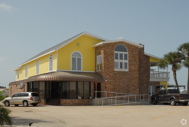

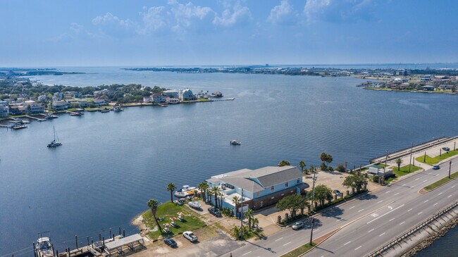
Property Detail
1721 61St St
7205-0000-0045-003
ABST 121 HALL & JONES SUR N 225 FT OF LOT 45 (45-3) TRIMBLE & LINDSEY SEC 1
Commercialnec
Galveston
REC
Texas
VE and V1-30 Coastal areas with a 1% or greater chance of flooding and an additional hazard associated with storm waves. These areas have a 26% chance of flooding over the life of a 30-year mortgage.
45
2024
1.71 AC
2025
Galveston & Texas City
725800
Houston
11,736 SF
Houston-Pasadena-The Woodlands, TX
NEARBY LISTINGS FOR SALE OR LEASE
DEMOGRAPHICS near 1721 61St St
1 mile
3 mile
5 mile
2025 Total Population
15,993
44,816
60,352
2030 Population
16,666
47,362
64,108
Pop Growth 2025-2030
+ 4.21%
+ 5.68%
+ 6.22%
Average Age
41
42
42
2025 Total Households
6,127
18,708
26,395
HH Growth 2025-2030
+ 4.15%
+ 5.97%
+ 6.56%
Median Household Inc
$57,311
$56,993
$57,188
Avg Household Size
2.30
2.20
2.10
2025 Avg HH Vehicles
2.00
1.00
1.00
Median Home Value
$276,066
$307,445
$329,742
Median Year Built
1973
1970
1971
Nearby Places
Map Layers
Map Styles
 Street
 Aerial
Layers
 Traffic
 Biking
Places
Listings with unknown addresses are not visible on the map
- Restaurants
- Banks
- Shops
- Fitness
- Groceries
PUBLIC TRANSPORTATION
AIRPORT
William P Hobby
Drive
Walk
Distance
William P Hobby
54 min
39.0 mi
Freight Ports
Port of Galveston
Drive
Walk
Distance
Port of Galveston
4 min
2.0 mi
SALE & LEASE HISTORY
LISTING DATE
SALE/LEASE

Sep 17, 2021
For Sale
Nearby Properties
Address
Land Use
TOTAL SIZE
Lot Size
Zoning
Address
Land Use
TOTAL SIZE
Lot Size
Zoning
566,062 SF
40.20 AC
Address
Land Use
TOTAL SIZE
Lot Size
Zoning
1,459,569 SF
11.51 AC
MF1
Address
Land Use
TOTAL SIZE
Lot Size
Zoning
161,300 SF
Address
Land Use
TOTAL SIZE
Lot Size
Zoning
678,840 SF
3.54 AC
R
Address
Land Use
TOTAL SIZE
Lot Size
Zoning
226,301 SF
5.93 AC
I
Address
Land Use
TOTAL SIZE
Lot Size
Zoning
157,959 SF
1.79 AC
Address
Land Use
TOTAL SIZE
Lot Size
Zoning
382,106 SF
24.02 AC
PD
Address
Land Use
TOTAL SIZE
Lot Size
Zoning
228,895 SF
11.41 AC
R
Address
Land Use
TOTAL SIZE
Lot Size
Zoning
153,637 SF
4.52 AC
R
Address
Land Use
TOTAL SIZE
Lot Size
Zoning
169,384 SF
709.59 AC
PD
Address
Land Use
TOTAL SIZE
Lot Size
Zoning
275,380 SF
15.41 AC
PD
Address
Land Use
TOTAL SIZE
Lot Size
Zoning
182,000 SF
41.90 AC
Address
Land Use
TOTAL SIZE
Lot Size
Zoning
Address
Land Use
TOTAL SIZE
Lot Size
Zoning
165,091 SF
Address
Land Use
TOTAL SIZE
Lot Size
Zoning
176,242 SF
2.03 AC
MF2
Address
Land Use
TOTAL SIZE
Lot Size
Zoning
450,048 SF
Address
Land Use
TOTAL SIZE
Lot Size
Zoning
144,000 SF
Address
Land Use
TOTAL SIZE
Lot Size
Zoning
128,906 SF
Address
Land Use
TOTAL SIZE
Lot Size
Zoning
88,994 SF
3.03 AC
R
Address
Land Use
TOTAL SIZE
Lot Size
Zoning
193,003 SF
7.08 AC
C
Address
Land Use
TOTAL SIZE
Lot Size
Zoning
119,996 SF
2.86 AC
Address
Land Use
TOTAL SIZE
Lot Size
Zoning
174,713 SF
6.54 AC
C
Address
Land Use
TOTAL SIZE
Lot Size
Zoning
169,404 SF
7.50 AC
R
Address
Land Use
TOTAL SIZE
Lot Size
Zoning
80,908 SF
0.70 AC
Address
Land Use
TOTAL SIZE
Lot Size
Zoning
131,333 SF
4.80 AC
Address
Land Use
TOTAL SIZE
Lot Size
Zoning
20.09 AC
Address
Land Use
TOTAL SIZE
Lot Size
Zoning
153,210 SF
13.27 AC
R
Address
Land Use
TOTAL SIZE
Lot Size
Zoning
121,734 SF
12.27 AC
IF1
Address
Land Use
TOTAL SIZE
Lot Size
Zoning
136,712 SF
6 AC
C
Address
Land Use
TOTAL SIZE
Lot Size
Zoning
105,544 SF
13.27 AC
PD
The World's #1 Commercial Real Estate Marketplace
Connect with us
© 2026 CoStar Group
The information above has been obtained from sources believed reliable. While we do not doubt its accuracy we have not verified it and make no guarantee, warranty or representation about it. It is your responsibility to independently confirm its accuracy and completeness. Any projections, opinions, assumptions, or estimates used are for example only and do not represent the current or future performance of the property. The value of this transaction to you depends on tax and other factors which should be evaluated by your tax, financial, and legal advisors. You and your advisors should conduct a careful, independent investigation of the property to determine to your satisfaction the suitability of the property for your needs.