Property Record
Wayside Rd, Cleveland, OH 44112
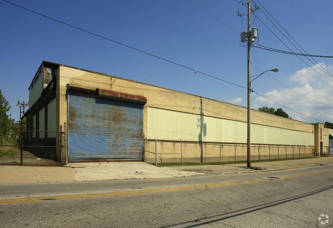
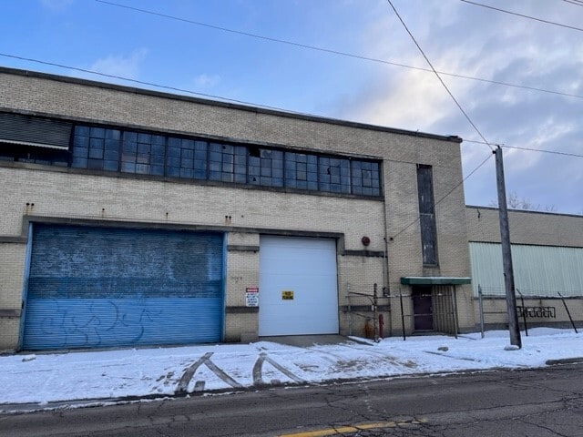
This Property Is For Sale
NEARBY LISTINGS FOR SALE OR LEASE
Property Detail
Wayside Rd
Cleveland-Elyria, OH
117 6 Cleveland East
117-06-056
9 EST 5.31A 0001
Lightindustrial
Cuyahoga
X
Ohio
39035C0091E
1
2024
2.66 AC
2024
Euclid
117900
Cleveland
DEMOGRAPHICS near Wayside Rd
1 Mile
3 Mile
5 Mile
2024 Total Population
13,797
108,636
257,730
2029 Population
13,582
107,919
255,077
Pop Growth 2024-2029
(1.56%)
(0.66%)
(1.03%)
Average Age
43
42
41
2024 Total Households
6,921
50,406
115,345
HH Growth 2024-2029
(1.72%)
(0.83%)
(1.06%)
Median Household Inc
$26,991
$34,597
$42,599
Avg Household Size
1.90
2.10
2.10
2024 Avg HH Vehicles
1.00
1.00
1.00
Median Home Value
$69,235
$97,213
$136,701
Median Year Built
1951
1950
1951
Nearby Places
- Restaurants
- Banks
- Shops
- Fitness
- Groceries
PUBLIC TRANSPORTATION
COMMUTER RAIL
Cleveland Lakefront Station (Blue Line - Greater Cleveland Regional Transit Authority Rapid Transit (The Rapid), Green Line - Greater Cleveland Regional Transit Authority Rapid Transit (The Rapid))
DRIVE
WALK
Distance
Cleveland Lakefront Station (Blue Line - Greater Cleveland Regional Transit Authority Rapid Transit (The Rapid), Green Line - Greater Cleveland Regional Transit Authority Rapid Transit (The Rapid))
19 min
9.6 mi
AIRPORT
Cleveland-Hopkins International
DRIVE
WALK
Distance
Cleveland-Hopkins International
38 min
23.1 mi
Freight Ports
Port of Toledo
DRIVE
WALK
Distance
Port of Toledo
152 min
123.5 mi
Nearby Properties
Address
Land Use
TOTAL SIZE
Lot Size
Zoning
Address
Land Use
TOTAL SIZE
Lot Size
Zoning
63.59 AC
1F
Address
Land Use
TOTAL SIZE
Lot Size
Zoning
44,577 SF
39.90 AC
SI
Address
Land Use
TOTAL SIZE
Lot Size
Zoning
257,048 SF
17.93 AC
S1
Address
Land Use
TOTAL SIZE
Lot Size
Zoning
112,657 SF
19.88 AC
U3
Address
Land Use
TOTAL SIZE
Lot Size
Zoning
450,285 SF
6.02 AC
LR
Address
Land Use
TOTAL SIZE
Lot Size
Zoning
2.53 AC
U6
Address
Land Use
TOTAL SIZE
Lot Size
Zoning
222,426 SF
3.60 AC
U1
Address
Land Use
TOTAL SIZE
Lot Size
Zoning
358,748 SF
10 AC
2F
Address
Land Use
TOTAL SIZE
Lot Size
Zoning
100,469 SF
25.96 AC
AA
Address
Land Use
TOTAL SIZE
Lot Size
Zoning
270,472 SF
5.92 AC
GR
Address
Land Use
TOTAL SIZE
Lot Size
Zoning
197,976 SF
20.43 AC
SI-B3
Address
Land Use
TOTAL SIZE
Lot Size
Zoning
275,040 SF
9.07 AC
U3
Address
Land Use
TOTAL SIZE
Lot Size
Zoning
157,258 SF
22.76 AC
SI
Address
Land Use
TOTAL SIZE
Lot Size
Zoning
34.14 AC
U6
Address
Land Use
TOTAL SIZE
Lot Size
Zoning
27,466 SF
13.39 AC
U6
Address
Land Use
TOTAL SIZE
Lot Size
Zoning
61,352 SF
10.79 AC
M-I
Address
Land Use
TOTAL SIZE
Lot Size
Zoning
129,593 SF
72.95 AC
P
Address
Land Use
TOTAL SIZE
Lot Size
Zoning
177,822 SF
0.18 AC
2F
Address
Land Use
TOTAL SIZE
Lot Size
Zoning
12,615 SF
7.53 AC
O
Address
Land Use
TOTAL SIZE
Lot Size
Zoning
127,630 SF
3.19 AC
MF-1
Address
Land Use
TOTAL SIZE
Lot Size
Zoning
339,686 SF
5.65 AC
2F
Address
Land Use
TOTAL SIZE
Lot Size
Zoning
70,953 SF
8.66 AC
CI
Address
Land Use
TOTAL SIZE
Lot Size
Zoning
251,689 SF
2.13 AC
LR
Address
Land Use
TOTAL SIZE
Lot Size
Zoning
235,391 SF
4.90 AC
S1
Address
Land Use
TOTAL SIZE
Lot Size
Zoning
130,965 SF
11.80 AC
U1
Address
Land Use
TOTAL SIZE
Lot Size
Zoning
57.04 AC
Address
Land Use
TOTAL SIZE
Lot Size
Zoning
70,548 SF
5.97 AC
CI
Address
Land Use
TOTAL SIZE
Lot Size
Zoning
103,610 SF
4.58 AC
2F
Address
Land Use
TOTAL SIZE
Lot Size
Zoning
76,053 SF
5.03 AC
2F
Address
Land Use
TOTAL SIZE
Lot Size
Zoning
42,470 SF
12.35 AC
U1
The World's #1 Commercial Real Estate Marketplace
Connect with us
© 2025 CoStar Group
The information above has been obtained from sources believed reliable. While we do not doubt its accuracy we have not verified it and make no guarantee, warranty or representation about it. It is your responsibility to independently confirm its accuracy and completeness. Any projections, opinions, assumptions, or estimates used are for example only and do not represent the current or future performance of the property. The value of this transaction to you depends on tax and other factors which should be evaluated by your tax, financial, and legal advisors. You and your advisors should conduct a careful, independent investigation of the property to determine to your satisfaction the suitability of the property for your needs.