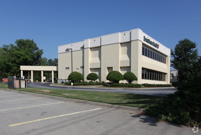
Property Record
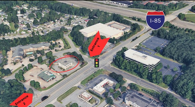
1725 Indian Trail Lilburn Rd, Norcross, GA 30093

Current Lease Availabilities
Property Detail
1725 Indian Trail Lilburn Rd
6-198-064
WILLOW OAK TRAIL
Financialbuilding
Gwinnett
C2
Georgia
B and X Area of moderate flood hazard, usually the area between the limits of the 100-year and 500-year floods.
198
2025
1.10 AC
2025
Lawrenceville/Lilburn
050438
Atlanta
11,384 SF
Atlanta-Sandy Springs-Roswell, GA
NEARBY LISTINGS FOR SALE OR LEASE
DEMOGRAPHICS near 1725 Indian Trail Lilburn Rd
1 mile
3 mile
5 mile
2025 Total Population
7,972
110,371
269,165
2030 Population
8,296
114,438
278,965
Pop Growth 2025-2030
+ 4.06%
+ 3.68%
+ 3.64%
Average Age
35
35
36
2025 Total Households
2,635
36,419
95,825
HH Growth 2025-2030
+ 4.17%
+ 3.73%
+ 3.62%
Median Household Inc
$50,385
$59,074
$64,939
Avg Household Size
3.00
3.00
2.70
2025 Avg HH Vehicles
2.00
2.00
2.00
Median Home Value
$240,032
$324,318
$361,840
Median Year Built
1988
1988
1988
Nearby Places
Map Layers
Map Styles
 Street
 Aerial
Transit
 Traffic
 Biking
Places
Listings with unknown addresses are not visible on the map
- Restaurants
- Banks
- Shops
- Fitness
- Groceries
PUBLIC TRANSPORTATION
AIRPORT
Hartsfield - Jackson Atlanta International
Drive
Walk
Distance
Hartsfield - Jackson Atlanta International
40 min
29.4 mi
Freight Ports
Georgia Ports - Savannah
Drive
Walk
Distance
Georgia Ports - Savannah
297 min
264.3 mi
Nearby Properties
Address
Land Use
TOTAL SIZE
Lot Size
Zoning
Address
Land Use
TOTAL SIZE
Lot Size
Zoning
709,399 SF
59.34 AC
RM13
Address
Land Use
TOTAL SIZE
Lot Size
Zoning
761,929 SF
65.19 AC
RM13
Address
Land Use
TOTAL SIZE
Lot Size
Zoning
425,597 SF
49.61 AC
RM13
Address
Land Use
TOTAL SIZE
Lot Size
Zoning
338,670 SF
28.61 AC
RM
Address
Land Use
TOTAL SIZE
Lot Size
Zoning
439,676 SF
42.88 AC
RM13
Address
Land Use
TOTAL SIZE
Lot Size
Zoning
247,662 SF
29.53 AC
RM
Address
Land Use
TOTAL SIZE
Lot Size
Zoning
503,097 SF
40 AC
RM13
Address
Land Use
TOTAL SIZE
Lot Size
Zoning
525,526 SF
80.61 AC
RA200
Address
Land Use
TOTAL SIZE
Lot Size
Zoning
361,593 SF
13.35 AC
RM24
Address
Land Use
TOTAL SIZE
Lot Size
Zoning
285,440 SF
24.68 AC
RM
Address
Land Use
TOTAL SIZE
Lot Size
Zoning
413,878 SF
29.13 AC
CB
Address
Land Use
TOTAL SIZE
Lot Size
Zoning
332,235 SF
17.76 AC
C2
Address
Land Use
TOTAL SIZE
Lot Size
Zoning
455,471 SF
48.23 AC
R75
Address
Land Use
TOTAL SIZE
Lot Size
Zoning
483,279 SF
8.27 AC
BH
Address
Land Use
TOTAL SIZE
Lot Size
Zoning
364,994 SF
34.06 AC
RM13
Address
Land Use
TOTAL SIZE
Lot Size
Zoning
475,389 SF
5.37 AC
NX
Address
Land Use
TOTAL SIZE
Lot Size
Zoning
561,975 SF
41.78 AC
RM13
Address
Land Use
TOTAL SIZE
Lot Size
Zoning
321,756 SF
26.28 AC
RM
Address
Land Use
TOTAL SIZE
Lot Size
Zoning
340,962 SF
34.50 AC
PRD
Address
Land Use
TOTAL SIZE
Lot Size
Zoning
356,488 SF
33 AC
RM10
Address
Land Use
TOTAL SIZE
Lot Size
Zoning
308,378 SF
35.62 AC
C3
Address
Land Use
TOTAL SIZE
Lot Size
Zoning
454,220 SF
30 AC
M1
Address
Land Use
TOTAL SIZE
Lot Size
Zoning
220,915 SF
2.38 AC
HX
Address
Land Use
TOTAL SIZE
Lot Size
Zoning
285,384 SF
21.32 AC
RM
Address
Land Use
TOTAL SIZE
Lot Size
Zoning
720,051 SF
99.46 AC
MUR
Address
Land Use
TOTAL SIZE
Lot Size
Zoning
371,383 SF
29.56 AC
RM13
Address
Land Use
TOTAL SIZE
Lot Size
Zoning
236,654 SF
9.53 AC
RM24
Address
Land Use
TOTAL SIZE
Lot Size
Zoning
351,072 SF
20.03 AC
RM24
Address
Land Use
TOTAL SIZE
Lot Size
Zoning
781,705 SF
60.29 AC
M1
Address
Land Use
TOTAL SIZE
Lot Size
Zoning
367,517 SF
34.61 AC
RM13
The World's #1 Commercial Real Estate Marketplace
Connect with us
© 2026 CoStar Group
The information above has been obtained from sources believed reliable. While we do not doubt its accuracy we have not verified it and make no guarantee, warranty or representation about it. It is your responsibility to independently confirm its accuracy and completeness. Any projections, opinions, assumptions, or estimates used are for example only and do not represent the current or future performance of the property. The value of this transaction to you depends on tax and other factors which should be evaluated by your tax, financial, and legal advisors. You and your advisors should conduct a careful, independent investigation of the property to determine to your satisfaction the suitability of the property for your needs.