Property Record
17380 Groschke Rd, Houston, TX 77084
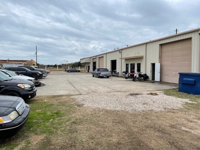
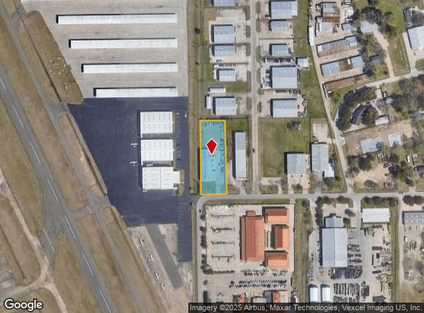
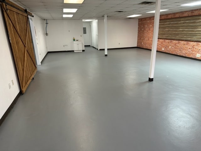
This Property Is For Sale
NEARBY LISTINGS FOR SALE OR LEASE
Property Detail
17380 Groschke Rd
1217940010001
Westside Business Park Sec 1
Warehouse
RES A BLK 1 WESTSIDE BUSINESS PARK SEC 1
X
Harris
48201C0610M
Texas
2024
1.02 AC
2025
Northwest Outliers
541701
Houston
8,250 SF
Houston-The Woodlands-Sugar Land, TX
DEMOGRAPHICS near 17380 Groschke Rd
1 Mile
3 Mile
5 Mile
2024 Total Population
4,212
84,697
278,983
2029 Population
4,245
86,160
283,714
Pop Growth 2024-2029
+ 0.78%
+ 1.73%
+ 1.70%
Average Age
35
36
36
2024 Total Households
1,133
27,913
92,388
HH Growth 2024-2029
+ 0.88%
+ 1.82%
+ 1.67%
Median Household Inc
$86,150
$74,743
$76,979
Avg Household Size
3.50
3.00
2.90
2024 Avg HH Vehicles
2.00
2.00
2.00
Median Home Value
$201,818
$203,328
$216,335
Median Year Built
2006
1995
1997
Nearby Places
Map Layers
Map Styles
 Street
 Aerial
- Restaurants
- Banks
- Shops
- Fitness
- Groceries
PUBLIC TRANSPORTATION
AIRPORT
George Bush Intcntl/Houston
DRIVE
WALK
Distance
George Bush Intcntl/Houston
44 min
31.9 mi
William P Hobby
DRIVE
WALK
Distance
William P Hobby
54 min
34.2 mi
Freight Ports
Port of Houston
DRIVE
WALK
Distance
Port of Houston
48 min
31.0 mi
Nearby Properties
Address
Land Use
TOTAL SIZE
Lot Size
Zoning
Address
Land Use
TOTAL SIZE
Lot Size
Zoning
695,923 SF
6.63 AC
Address
Land Use
TOTAL SIZE
Lot Size
Zoning
681,561 SF
7.98 AC
Address
Land Use
TOTAL SIZE
Lot Size
Zoning
439,347 SF
13.50 AC
Address
Land Use
TOTAL SIZE
Lot Size
Zoning
375,486 SF
12.36 AC
Address
Land Use
TOTAL SIZE
Lot Size
Zoning
341,844 SF
16.71 AC
Address
Land Use
TOTAL SIZE
Lot Size
Zoning
343,605 SF
11.90 AC
Address
Land Use
TOTAL SIZE
Lot Size
Zoning
538,027 SF
30.06 AC
Address
Land Use
TOTAL SIZE
Lot Size
Zoning
320,084 SF
8.01 AC
Address
Land Use
TOTAL SIZE
Lot Size
Zoning
467,663 SF
7.30 AC
Address
Land Use
TOTAL SIZE
Lot Size
Zoning
284,321 SF
10.54 AC
Address
Land Use
TOTAL SIZE
Lot Size
Zoning
458,613 SF
19.50 AC
Address
Land Use
TOTAL SIZE
Lot Size
Zoning
334,724 SF
21.23 AC
Address
Land Use
TOTAL SIZE
Lot Size
Zoning
489,188 SF
5.99 AC
Address
Land Use
TOTAL SIZE
Lot Size
Zoning
294,642 SF
14.47 AC
Address
Land Use
TOTAL SIZE
Lot Size
Zoning
370,329 SF
5 AC
Address
Land Use
TOTAL SIZE
Lot Size
Zoning
363,880 SF
17.32 AC
Address
Land Use
TOTAL SIZE
Lot Size
Zoning
305,624 SF
Address
Land Use
TOTAL SIZE
Lot Size
Zoning
323,753 SF
14.02 AC
Address
Land Use
TOTAL SIZE
Lot Size
Zoning
486,927 SF
5.88 AC
Address
Land Use
TOTAL SIZE
Lot Size
Zoning
170,903 SF
15.53 AC
Address
Land Use
TOTAL SIZE
Lot Size
Zoning
335,483 SF
13.83 AC
Address
Land Use
TOTAL SIZE
Lot Size
Zoning
331,923 SF
13.27 AC
Address
Land Use
TOTAL SIZE
Lot Size
Zoning
229,728 SF
5.92 AC
Address
Land Use
TOTAL SIZE
Lot Size
Zoning
347,192 SF
16.10 AC
Address
Land Use
TOTAL SIZE
Lot Size
Zoning
219,426 SF
10.23 AC
Address
Land Use
TOTAL SIZE
Lot Size
Zoning
119,940 SF
6.13 AC
Address
Land Use
TOTAL SIZE
Lot Size
Zoning
262,492 SF
10.04 AC
Address
Land Use
TOTAL SIZE
Lot Size
Zoning
277,552 SF
15.41 AC
Address
Land Use
TOTAL SIZE
Lot Size
Zoning
18.16 AC
Address
Land Use
TOTAL SIZE
Lot Size
Zoning
213,189 SF
1.69 AC
The World's #1 Commercial Real Estate Marketplace
Connect with us
© 2026 CoStar Group
The information above has been obtained from sources believed reliable. While we do not doubt its accuracy we have not verified it and make no guarantee, warranty or representation about it. It is your responsibility to independently confirm its accuracy and completeness. Any projections, opinions, assumptions, or estimates used are for example only and do not represent the current or future performance of the property. The value of this transaction to you depends on tax and other factors which should be evaluated by your tax, financial, and legal advisors. You and your advisors should conduct a careful, independent investigation of the property to determine to your satisfaction the suitability of the property for your needs.