Property Record
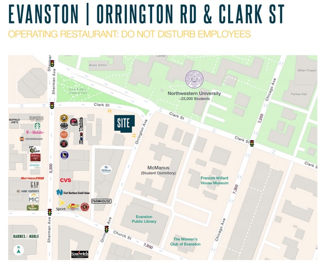
1740 Orrington Ave, Evanston, IL 60201


NEARBY LISTINGS FOR SALE OR LEASE
Property Detail
1740 Orrington Ave
11-18-127-019-0000
Village Of Evanston
Commercialbuilding
(VILLAGE) OF (EVANSTON) IN SECS 13-41-13 & 7,18 & 19- 41-14 SEC 18-41-14
X
Cook
17031C0266K
Illinois
2023
0.40 AC
2025
Near North
809402
Chicago
4,748 SF
Chicago-Naperville-Elgin, IL-IN-WI
DEMOGRAPHICS near 1740 Orrington Ave
1 Mile
3 Mile
5 Mile
2024 Total Population
30,905
166,184
413,255
2029 Population
30,295
161,615
402,029
Pop Growth 2024-2029
(1.97%)
(2.75%)
(2.72%)
Average Age
37
40
40
2024 Total Households
12,424
65,596
164,360
HH Growth 2024-2029
(1.83%)
(2.95%)
(2.94%)
Median Household Inc
$63,369
$80,570
$72,233
Avg Household Size
2.00
2.30
2.30
2024 Avg HH Vehicles
1.00
1.00
1.00
Median Home Value
$475,267
$428,965
$388,390
Median Year Built
1962
1951
1952
Nearby Places
Map Layers
Map Styles
 Street
 Aerial
- Restaurants
- Banks
- Shops
- Fitness
- Groceries
PUBLIC TRANSPORTATION
TRANSIT/SUBWAY
Davis Station (Purple Line - Chicago Transit Authority "L" Trains (The "L"))
DRIVE
WALK
Distance
Davis Station (Purple Line - Chicago Transit Authority "L" Trains (The "L"))
1 min
6 min
0.3 mi
Evanston Davis Street Station (Union Pacific North Line - Northeast Illinois Regional Commuter Railroad (Metra))
DRIVE
WALK
Distance
Evanston Davis Street Station (Union Pacific North Line - Northeast Illinois Regional Commuter Railroad (Metra))
1 min
7 min
0.4 mi
Foster Station (Purple Line - Chicago Transit Authority "L" Trains (The "L"))
DRIVE
WALK
Distance
Foster Station (Purple Line - Chicago Transit Authority "L" Trains (The "L"))
1 min
9 min
0.5 mi
Dempster Station (Purple Line - Chicago Transit Authority "L" Trains (The "L"))
DRIVE
WALK
Distance
Dempster Station (Purple Line - Chicago Transit Authority "L" Trains (The "L"))
1 min
11 min
0.6 mi
Noyes Station (Purple Line - Chicago Transit Authority "L" Trains (The "L"))
DRIVE
WALK
Distance
Noyes Station (Purple Line - Chicago Transit Authority "L" Trains (The "L"))
2 min
14 min
0.7 mi
COMMUTER RAIL
Evanston Davis Street Station (Union Pacific North Line - Northeast Illinois Regional Commuter Railroad (Metra))
DRIVE
WALK
Distance
Evanston Davis Street Station (Union Pacific North Line - Northeast Illinois Regional Commuter Railroad (Metra))
1 min
7 min
0.4 mi
Evanston Main Street Station (Union Pacific North Line - Northeast Illinois Regional Commuter Railroad (Metra))
DRIVE
WALK
Distance
Evanston Main Street Station (Union Pacific North Line - Northeast Illinois Regional Commuter Railroad (Metra))
4 min
1.3 mi
AIRPORT
Chicago O'Hare International
DRIVE
WALK
Distance
Chicago O'Hare International
53 min
20.9 mi
Chicago Midway International
DRIVE
WALK
Distance
Chicago Midway International
44 min
23.0 mi
SALE & LEASE HISTORY
LISTING DATE
SALE/LEASE

Jan 21, 2021
For Sale
Nearby Properties
Address
Land Use
TOTAL SIZE
Lot Size
Zoning
Address
Land Use
TOTAL SIZE
Lot Size
Zoning
180,397 SF
0.78 AC
Address
Land Use
TOTAL SIZE
Lot Size
Zoning
0.63 AC
Address
Land Use
TOTAL SIZE
Lot Size
Zoning
892,012 SF
37.29 AC
Address
Land Use
TOTAL SIZE
Lot Size
Zoning
341,698 SF
0.64 AC
Address
Land Use
TOTAL SIZE
Lot Size
Zoning
303,960 SF
0.98 AC
Address
Land Use
TOTAL SIZE
Lot Size
Zoning
0.84 AC
Address
Land Use
TOTAL SIZE
Lot Size
Zoning
251,409 SF
16.33 AC
Address
Land Use
TOTAL SIZE
Lot Size
Zoning
176,115 SF
1.04 AC
Address
Land Use
TOTAL SIZE
Lot Size
Zoning
218,982 SF
1.97 AC
Address
Land Use
TOTAL SIZE
Lot Size
Zoning
243,781 SF
0.84 AC
Address
Land Use
TOTAL SIZE
Lot Size
Zoning
110,528 SF
3.05 AC
Address
Land Use
TOTAL SIZE
Lot Size
Zoning
0.84 AC
Address
Land Use
TOTAL SIZE
Lot Size
Zoning
Address
Land Use
TOTAL SIZE
Lot Size
Zoning
145,548 SF
0.80 AC
Address
Land Use
TOTAL SIZE
Lot Size
Zoning
8,550 SF
0.25 AC
Address
Land Use
TOTAL SIZE
Lot Size
Zoning
1.67 AC
Address
Land Use
TOTAL SIZE
Lot Size
Zoning
2.46 AC
Address
Land Use
TOTAL SIZE
Lot Size
Zoning
208,785 SF
0.61 AC
Address
Land Use
TOTAL SIZE
Lot Size
Zoning
5.65 AC
Address
Land Use
TOTAL SIZE
Lot Size
Zoning
190,350 SF
1.03 AC
Address
Land Use
TOTAL SIZE
Lot Size
Zoning
0.30 AC
Address
Land Use
TOTAL SIZE
Lot Size
Zoning
0.38 AC
Address
Land Use
TOTAL SIZE
Lot Size
Zoning
223,366 SF
0.65 AC
Address
Land Use
TOTAL SIZE
Lot Size
Zoning
72,503 SF
5.60 AC
Address
Land Use
TOTAL SIZE
Lot Size
Zoning
117,229 SF
Address
Land Use
TOTAL SIZE
Lot Size
Zoning
1.62 AC
Address
Land Use
TOTAL SIZE
Lot Size
Zoning
119,468 SF
0.57 AC
Address
Land Use
TOTAL SIZE
Lot Size
Zoning
47,283 SF
1.18 AC
Address
Land Use
TOTAL SIZE
Lot Size
Zoning
61,840 SF
0.28 AC
The World's #1 Commercial Real Estate Marketplace
Connect with us
© 2026 CoStar Group
The information above has been obtained from sources believed reliable. While we do not doubt its accuracy we have not verified it and make no guarantee, warranty or representation about it. It is your responsibility to independently confirm its accuracy and completeness. Any projections, opinions, assumptions, or estimates used are for example only and do not represent the current or future performance of the property. The value of this transaction to you depends on tax and other factors which should be evaluated by your tax, financial, and legal advisors. You and your advisors should conduct a careful, independent investigation of the property to determine to your satisfaction the suitability of the property for your needs.