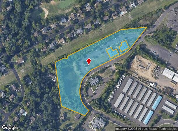
Property Record
1741 Kendarbren Dr, Jamison, PA 18929
NEARBY LISTINGS FOR SALE OR LEASE
Property Detail
1741 Kendarbren Dr
Philadelphia
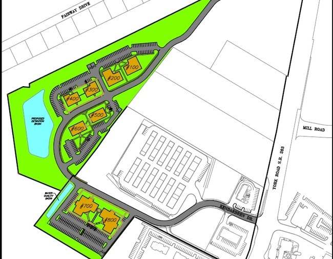
Common Area Warwick Office Park
Philadelphia-Camden-Wilmington, PA-NJ-DE-MD
6.54AC LOT #1 COMMON AREA WARWICK OFFICE PARK 1217ON KENDARBREN DR
51-003-055
Bucks
Commercialnec
Pennsylvania
2024
1
2025
6.54 AC
104901
Lower Bucks County
6,400 SF
DEMOGRAPHICS near 1741 Kendarbren Dr
1 Mile
3 Mile
5 Mile
2024 Total Population
5,932
44,644
121,201
2029 Population
5,869
44,689
121,745
Pop Growth 2024-2029
(1.06%)
+ 0.10%
+ 0.45%
Average Age
42
43
44
2024 Total Households
2,002
15,791
45,727
HH Growth 2024-2029
(1.15%)
+ 0.09%
+ 0.57%
Median Household Inc
$162,265
$123,364
$108,946
Avg Household Size
2.90
2.70
2.50
2024 Avg HH Vehicles
2.00
2.00
2.00
Median Home Value
$642,633
$451,891
$447,036
Median Year Built
1992
1985
1982
Nearby Places
Map Layers
Map Styles
 Street
 Aerial
- Restaurants
- Banks
- Shops
- Fitness
- Groceries
PUBLIC TRANSPORTATION
COMMUTER RAIL
Warminster (R2 - Southeastern Pennsylvania Transportation Authority Regional Rail (SEPTA Regional Rail))
DRIVE
WALK
Distance
Warminster (R2 - Southeastern Pennsylvania Transportation Authority Regional Rail (SEPTA Regional Rail))
10 min
5.3 mi
Doylestown (R5 - Southeastern Pennsylvania Transportation Authority Regional Rail (SEPTA Regional Rail))
DRIVE
WALK
Distance
Doylestown (R5 - Southeastern Pennsylvania Transportation Authority Regional Rail (SEPTA Regional Rail))
12 min
5.7 mi
AIRPORT
Trenton Mercer
DRIVE
WALK
Distance
Trenton Mercer
36 min
19.6 mi
Philadelphia International
DRIVE
WALK
Distance
Philadelphia International
64 min
37.6 mi
Lehigh Valley International
DRIVE
WALK
Distance
Lehigh Valley International
66 min
38.4 mi
Freight Ports
Port of Philadelphia
DRIVE
WALK
Distance
Port of Philadelphia
41 min
23.3 mi
Nearby Properties
Address
Land Use
TOTAL SIZE
Lot Size
Zoning
Address
Land Use
TOTAL SIZE
Lot Size
Zoning
254,330 SF
25.38 AC
C2
Address
Land Use
TOTAL SIZE
Lot Size
Zoning
89,344 SF
9.69 AC
R2
Address
Land Use
TOTAL SIZE
Lot Size
Zoning
146,924 SF
17.47 AC
C2
Address
Land Use
TOTAL SIZE
Lot Size
Zoning
125,391 SF
14.03 AC
OBD
Address
Land Use
TOTAL SIZE
Lot Size
Zoning
77,630 SF
28.53 AC
R2B
Address
Land Use
TOTAL SIZE
Lot Size
Zoning
89,417 SF
13.30 AC
CR
Address
Land Use
TOTAL SIZE
Lot Size
Zoning
94,916 SF
13.98 AC
SC
Address
Land Use
TOTAL SIZE
Lot Size
Zoning
25,188 SF
8.51 AC
R2
Address
Land Use
TOTAL SIZE
Lot Size
Zoning
153,564 SF
13.12 AC
R2
Address
Land Use
TOTAL SIZE
Lot Size
Zoning
63,612 SF
0.47 AC
CI
Address
Land Use
TOTAL SIZE
Lot Size
Zoning
38,320 SF
11.91 AC
AG
Address
Land Use
TOTAL SIZE
Lot Size
Zoning
97,361 SF
5.62 AC
R2
Address
Land Use
TOTAL SIZE
Lot Size
Zoning
92,454 SF
12.48 AC
R1
Address
Land Use
TOTAL SIZE
Lot Size
Zoning
33,658 SF
0.52 AC
Address
Land Use
TOTAL SIZE
Lot Size
Zoning
137,592 SF
18.52 AC
LI
Address
Land Use
TOTAL SIZE
Lot Size
Zoning
63,612 SF
0.50 AC
CI
Address
Land Use
TOTAL SIZE
Lot Size
Zoning
61,558 SF
7.48 AC
C2
Address
Land Use
TOTAL SIZE
Lot Size
Zoning
26,134 SF
8.37 AC
C2
Address
Land Use
TOTAL SIZE
Lot Size
Zoning
31,122 SF
9.86 AC
C2
Address
Land Use
TOTAL SIZE
Lot Size
Zoning
24,300 SF
3.36 AC
C1
Address
Land Use
TOTAL SIZE
Lot Size
Zoning
63,524 SF
6.06 AC
C1
Address
Land Use
TOTAL SIZE
Lot Size
Zoning
63,612 SF
0.52 AC
CI
Address
Land Use
TOTAL SIZE
Lot Size
Zoning
44,303 SF
7.40 AC
C
Address
Land Use
TOTAL SIZE
Lot Size
Zoning
26,829 SF
11.86 AC
C3
Address
Land Use
TOTAL SIZE
Lot Size
Zoning
30,184 SF
1.59 AC
OI
Address
Land Use
TOTAL SIZE
Lot Size
Zoning
8.22 AC
C2
Address
Land Use
TOTAL SIZE
Lot Size
Zoning
50,485 SF
5.10 AC
R2
Address
Land Use
TOTAL SIZE
Lot Size
Zoning
46,120 SF
9.55 AC
C1
Address
Land Use
TOTAL SIZE
Lot Size
Zoning
70,250 SF
6.40 AC
I1
Address
Land Use
TOTAL SIZE
Lot Size
Zoning
98,876 SF
7.11 AC
LI
The World's #1 Commercial Real Estate Marketplace
Connect with us
© 2026 CoStar Group
The information above has been obtained from sources believed reliable. While we do not doubt its accuracy we have not verified it and make no guarantee, warranty or representation about it. It is your responsibility to independently confirm its accuracy and completeness. Any projections, opinions, assumptions, or estimates used are for example only and do not represent the current or future performance of the property. The value of this transaction to you depends on tax and other factors which should be evaluated by your tax, financial, and legal advisors. You and your advisors should conduct a careful, independent investigation of the property to determine to your satisfaction the suitability of the property for your needs.