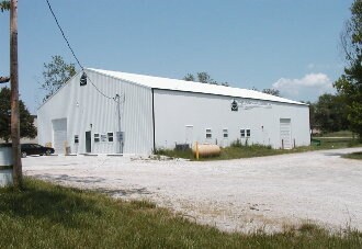
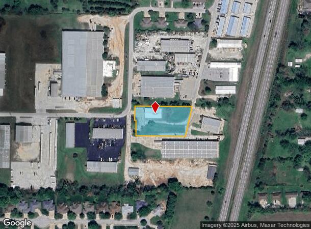
Property Record
1748 N Deffer Dr, Nixa, MO 65714
NEARBY LISTINGS FOR SALE OR LEASE
Property Detail
1748 N Deffer Dr
10-0.1-02-001-002-010.000
Meadowview 1 2 3
Agriculturalland
TR 1 NE NE NWC S562 E322.73 SW196.18 W282.20 N194.66 TO POB.
X
Christian
29043C0058D
Missouri
2023
1.23 AC
2024
West Christian County
020202
Springfield
6,120 SF
Springfield, MO
DEMOGRAPHICS near 1748 N Deffer Dr
1 Mile
3 Mile
5 Mile
2024 Total Population
2,971
33,585
89,032
2029 Population
3,353
37,110
96,067
Pop Growth 2024-2029
+ 12.86%
+ 10.50%
+ 7.90%
Average Age
38
40
41
2024 Total Households
1,154
12,986
35,883
HH Growth 2024-2029
+ 12.91%
+ 10.60%
+ 7.75%
Median Household Inc
$64,846
$78,324
$73,498
Avg Household Size
2.60
2.60
2.40
2024 Avg HH Vehicles
2.00
2.00
2.00
Median Home Value
$217,318
$242,608
$240,943
Median Year Built
1993
1996
1995
Nearby Places
Map Layers
Map Styles
 Street
 Aerial
- Restaurants
- Banks
- Shops
- Fitness
- Groceries
PUBLIC TRANSPORTATION
AIRPORT
Springfield-Branson Ntl
DRIVE
WALK
Distance
Springfield-Branson Ntl
35 min
18.6 mi
Freight Ports
Tulsa Port of Inola
DRIVE
WALK
Distance
Tulsa Port of Inola
198 min
176.2 mi
Nearby Properties
Address
Land Use
TOTAL SIZE
Lot Size
Zoning
Address
Land Use
TOTAL SIZE
Lot Size
Zoning
26.20 AC
Address
Land Use
TOTAL SIZE
Lot Size
Zoning
310,792 SF
12.27 AC
Address
Land Use
TOTAL SIZE
Lot Size
Zoning
4.12 AC
INC
Address
Land Use
TOTAL SIZE
Lot Size
Zoning
5.59 AC
INC
Address
Land Use
TOTAL SIZE
Lot Size
Zoning
10,720 SF
9.71 AC
Address
Land Use
TOTAL SIZE
Lot Size
Zoning
39.87 AC
Address
Land Use
TOTAL SIZE
Lot Size
Zoning
126,557 SF
4.62 AC
INC
Address
Land Use
TOTAL SIZE
Lot Size
Zoning
30,049 SF
5.01 AC
Address
Land Use
TOTAL SIZE
Lot Size
Zoning
73,140 SF
10.80 AC
Address
Land Use
TOTAL SIZE
Lot Size
Zoning
19.78 AC
Address
Land Use
TOTAL SIZE
Lot Size
Zoning
3,080 SF
24.20 AC
Address
Land Use
TOTAL SIZE
Lot Size
Zoning
19,682 SF
7.17 AC
Address
Land Use
TOTAL SIZE
Lot Size
Zoning
13,750 SF
6.56 AC
Address
Land Use
TOTAL SIZE
Lot Size
Zoning
18.56 AC
Address
Land Use
TOTAL SIZE
Lot Size
Zoning
107,194 SF
39.40 AC
Address
Land Use
TOTAL SIZE
Lot Size
Zoning
23,660 SF
10 AC
Address
Land Use
TOTAL SIZE
Lot Size
Zoning
71,436 SF
2.86 AC
INC
Address
Land Use
TOTAL SIZE
Lot Size
Zoning
43,194 SF
18 AC
Address
Land Use
TOTAL SIZE
Lot Size
Zoning
31,570 SF
3.99 AC
Address
Land Use
TOTAL SIZE
Lot Size
Zoning
77,022 SF
9.46 AC
Address
Land Use
TOTAL SIZE
Lot Size
Zoning
13,836 SF
5.81 AC
Address
Land Use
TOTAL SIZE
Lot Size
Zoning
36,110 SF
7 AC
Address
Land Use
TOTAL SIZE
Lot Size
Zoning
22,920 SF
8.51 AC
Address
Land Use
TOTAL SIZE
Lot Size
Zoning
51,498 SF
39.26 AC
Address
Land Use
TOTAL SIZE
Lot Size
Zoning
13,940 SF
3.43 AC
Address
Land Use
TOTAL SIZE
Lot Size
Zoning
58,989 SF
3.25 AC
INC
Address
Land Use
TOTAL SIZE
Lot Size
Zoning
18,966 SF
4.71 AC
Address
Land Use
TOTAL SIZE
Lot Size
Zoning
200,000 SF
10 AC
Address
Land Use
TOTAL SIZE
Lot Size
Zoning
8,100 SF
6.95 AC
Address
Land Use
TOTAL SIZE
Lot Size
Zoning
40,726 SF
4.54 AC
The World's #1 Commercial Real Estate Marketplace
Connect with us
© 2025 CoStar Group
The information above has been obtained from sources believed reliable. While we do not doubt its accuracy we have not verified it and make no guarantee, warranty or representation about it. It is your responsibility to independently confirm its accuracy and completeness. Any projections, opinions, assumptions, or estimates used are for example only and do not represent the current or future performance of the property. The value of this transaction to you depends on tax and other factors which should be evaluated by your tax, financial, and legal advisors. You and your advisors should conduct a careful, independent investigation of the property to determine to your satisfaction the suitability of the property for your needs.