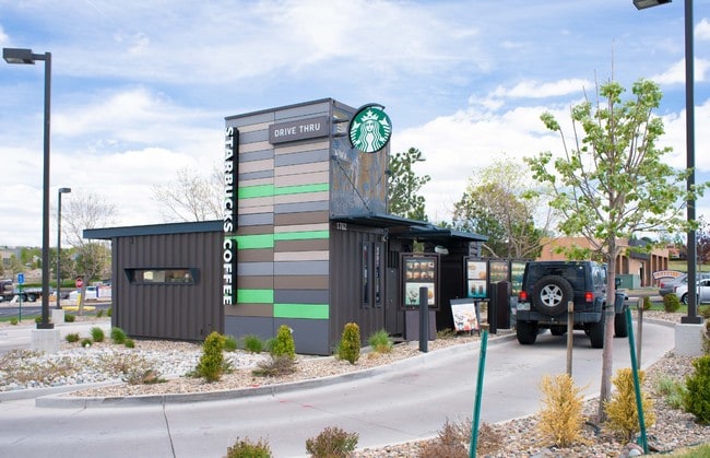
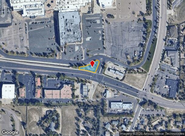
Property Record
Briargate Blvd, Colorado Springs, CO 80920
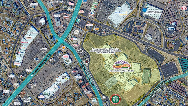
NEARBY LISTINGS FOR SALE OR LEASE
Property Detail
Briargate Blvd
Colorado Springs, CO
Chapel Hills Shopping Center Sub No 3
63054-01-017
LOT 3 BLK 1 CHAPEL HILLS SHOPPING CENTER SUB NO 3
Commercialnec
El Paso
X
Colorado
08041C0508G
3
2024
0.27 AC
2025
Northeast
003906
Colorado Springs
477 SF
DEMOGRAPHICS near Briargate Blvd
1 Mile
3 Mile
5 Mile
2024 Total Population
7,246
76,715
201,724
2029 Population
7,571
79,761
211,196
Pop Growth 2024-2029
+ 4.49%
+ 3.97%
+ 4.70%
Average Age
39
39
38
2024 Total Households
3,073
29,952
78,159
HH Growth 2024-2029
+ 4.75%
+ 4.16%
+ 4.87%
Median Household Inc
$84,428
$93,144
$90,319
Avg Household Size
2.30
2.50
2.50
2024 Avg HH Vehicles
2.00
2.00
2.00
Median Home Value
$406,239
$425,046
$430,287
Median Year Built
1987
1987
1991
Nearby Places
Map Layers
Map Styles
 Street
 Aerial
- Restaurants
- Banks
- Shops
- Fitness
- Groceries
PUBLIC TRANSPORTATION
AIRPORT
City of Colorado Springs Municipal
DRIVE
WALK
Distance
City of Colorado Springs Municipal
28 min
13.8 mi
SALE & LEASE HISTORY
LISTING DATE
SALE/LEASE

Sep 07, 2021
For Sale
Oct 18, 2017
For Sale
Jun 14, 2017
For Sale
Jul 13, 2021
For Sale
Nearby Properties
Address
Land Use
TOTAL SIZE
Lot Size
Zoning
Address
Land Use
TOTAL SIZE
Lot Size
Zoning
361,165 SF
59.11 AC
PDZ
Address
Land Use
TOTAL SIZE
Lot Size
Zoning
62,201 SF
5.68 AC
MX-N
Address
Land Use
TOTAL SIZE
Lot Size
Zoning
121,820 SF
14.73 AC
BP
Address
Land Use
TOTAL SIZE
Lot Size
Zoning
409,164 SF
19.26 AC
PUD
Address
Land Use
TOTAL SIZE
Lot Size
Zoning
103,166 SF
8.88 AC
BP
Address
Land Use
TOTAL SIZE
Lot Size
Zoning
86,020 SF
15.30 AC
R-1 6 CU H
Address
Land Use
TOTAL SIZE
Lot Size
Zoning
82,316 SF
4.08 AC
R-5/CR SS
Address
Land Use
TOTAL SIZE
Lot Size
Zoning
56,290 SF
6.55 AC
A/CR
Address
Land Use
TOTAL SIZE
Lot Size
Zoning
80,110 SF
2.61 AC
OR CU
Address
Land Use
TOTAL SIZE
Lot Size
Zoning
114,474 SF
12.95 AC
BP
Address
Land Use
TOTAL SIZE
Lot Size
Zoning
77,655 SF
8.39 AC
MX-N MX-N/
Address
Land Use
TOTAL SIZE
Lot Size
Zoning
1,251,233 SF
17.63 AC
BP/CR HR
Address
Land Use
TOTAL SIZE
Lot Size
Zoning
58,774 SF
5 AC
BP
Address
Land Use
TOTAL SIZE
Lot Size
Zoning
391,914 SF
3.13 AC
PDZ
Address
Land Use
TOTAL SIZE
Lot Size
Zoning
71,542 SF
10.11 AC
PF
Address
Land Use
TOTAL SIZE
Lot Size
Zoning
35,862 SF
5.95 AC
MX-N
Address
Land Use
TOTAL SIZE
Lot Size
Zoning
211,974 SF
25.15 AC
BP CU
Address
Land Use
TOTAL SIZE
Lot Size
Zoning
76,138 SF
4.84 AC
BP
Address
Land Use
TOTAL SIZE
Lot Size
Zoning
48,673 SF
5.51 AC
R-5 P
Address
Land Use
TOTAL SIZE
Lot Size
Zoning
45,141 SF
6.97 AC
R-5/CR
Address
Land Use
TOTAL SIZE
Lot Size
Zoning
50,471 SF
7.28 AC
BP
Address
Land Use
TOTAL SIZE
Lot Size
Zoning
158,502 SF
5.73 AC
MX-N HS
Address
Land Use
TOTAL SIZE
Lot Size
Zoning
47,313 SF
11.15 AC
MX-N
Address
Land Use
TOTAL SIZE
Lot Size
Zoning
25,194 SF
4 AC
R-5 P
Address
Land Use
TOTAL SIZE
Lot Size
Zoning
23,324 SF
7.84 AC
MX-N CU
Address
Land Use
TOTAL SIZE
Lot Size
Zoning
121,372 SF
59.10 AC
Address
Land Use
TOTAL SIZE
Lot Size
Zoning
241,088 SF
10.03 AC
BP HR
Address
Land Use
TOTAL SIZE
Lot Size
Zoning
42,365 SF
3.86 AC
MX-M CU SS
Address
Land Use
TOTAL SIZE
Lot Size
Zoning
122,531 SF
8.82 AC
BP
Address
Land Use
TOTAL SIZE
Lot Size
Zoning
222,253 SF
9.50 AC
BP HR
The World's #1 Commercial Real Estate Marketplace
Connect with us
© 2026 CoStar Group
The information above has been obtained from sources believed reliable. While we do not doubt its accuracy we have not verified it and make no guarantee, warranty or representation about it. It is your responsibility to independently confirm its accuracy and completeness. Any projections, opinions, assumptions, or estimates used are for example only and do not represent the current or future performance of the property. The value of this transaction to you depends on tax and other factors which should be evaluated by your tax, financial, and legal advisors. You and your advisors should conduct a careful, independent investigation of the property to determine to your satisfaction the suitability of the property for your needs.