Property Record
17667 Avenue 8, Delano, CA

Property Detail
17667 Avenue 8
Visalia, CA
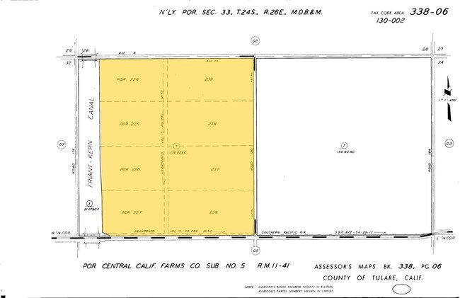
CEN CAL FRMS CO SUB 224 ETC
338-060-001-000
TULARE
Orchard
California
AE20
236
A Areas with a 1% annual chance of flooding and a 26% chance of flooding over the life of a 30-year mortgage.
139.82 AC
2024
SW Outlying Tulare County
2025
Visalia/Porterville
0043003171
NEARBY LISTINGS FOR SALE OR LEASE
-
-
View all Delano listings for sale on LoopNet.com
DEMOGRAPHICS near 17667 Avenue 8
1 mile
3 mile
5 mile
2025 Total Population
48
2,814
31,833
2030 Population
46
2,813
31,851
Pop Growth 2025-2030
(4.17%)
(0.04%)
+ 0.06%
Average Age
36
34
35
2025 Total Households
12
654
8,039
HH Growth 2025-2030
(8.33%)
(0.15%)
+ 0.14%
Median Household Inc
$43,499
$84,493
$65,571
Avg Household Size
4.00
4.30
3.80
2025 Avg HH Vehicles
2.00
3.00
2.00
Median Home Value
$450,000
$435,625
$310,609
Median Year Built
1962
1990
1982
Nearby Places
Map Layers
Map Styles
 Street
 Aerial
Layers
 Traffic
 Biking
Places
Listings with unknown addresses are not visible on the map
- Restaurants
- Banks
- Shops
- Fitness
- Groceries
PUBLIC TRANSPORTATION
AIRPORT
Meadows Field
Drive
Walk
Distance
Meadows Field
52 min
34.6 mi
Freight Ports
The Port of Hueneme
Drive
Walk
Distance
The Port of Hueneme
200 min
159.3 mi
Nearby Properties
Address
Land Use
TOTAL SIZE
Lot Size
Zoning
Address
Land Use
TOTAL SIZE
Lot Size
Zoning
115,071 SF
46.83 AC
R-1
Address
Land Use
TOTAL SIZE
Lot Size
Zoning
75.80 AC
A
Address
Land Use
TOTAL SIZE
Lot Size
Zoning
1,891 SF
20.03 AC
A
Address
Land Use
TOTAL SIZE
Lot Size
Zoning
6,969 SF
9.96 AC
A
Address
Land Use
TOTAL SIZE
Lot Size
Zoning
138,808 SF
18.84 AC
AE20
Address
Land Use
TOTAL SIZE
Lot Size
Zoning
18,538 SF
7.25 AC
R-1
Address
Land Use
TOTAL SIZE
Lot Size
Zoning
32.90 AC
AE20
Address
Land Use
TOTAL SIZE
Lot Size
Zoning
6,029 SF
310.81 AC
A
Address
Land Use
TOTAL SIZE
Lot Size
Zoning
134.34 AC
A
Address
Land Use
TOTAL SIZE
Lot Size
Zoning
75.66 AC
A
Address
Land Use
TOTAL SIZE
Lot Size
Zoning
9.13 AC
AE20
Address
Land Use
TOTAL SIZE
Lot Size
Zoning
161.80 AC
A
Address
Land Use
TOTAL SIZE
Lot Size
Zoning
163.68 AC
A
Address
Land Use
TOTAL SIZE
Lot Size
Zoning
133,332 SF
15.66 AC
A-1
Address
Land Use
TOTAL SIZE
Lot Size
Zoning
9.04 AC
A
Address
Land Use
TOTAL SIZE
Lot Size
Zoning
13.92 AC
AE20
Address
Land Use
TOTAL SIZE
Lot Size
Zoning
10 AC
M1
Address
Land Use
TOTAL SIZE
Lot Size
Zoning
18.84 AC
A
Address
Land Use
TOTAL SIZE
Lot Size
Zoning
138.19 AC
A
Address
Land Use
TOTAL SIZE
Lot Size
Zoning
154.84 AC
Address
Land Use
TOTAL SIZE
Lot Size
Zoning
5.75 AC
AE20
Address
Land Use
TOTAL SIZE
Lot Size
Zoning
1,092 SF
19.54 AC
A
Address
Land Use
TOTAL SIZE
Lot Size
Zoning
41.01 AC
Address
Land Use
TOTAL SIZE
Lot Size
Zoning
1,313 SF
18.64 AC
A
Address
Land Use
TOTAL SIZE
Lot Size
Zoning
61.98 AC
A
Address
Land Use
TOTAL SIZE
Lot Size
Zoning
5,441 SF
15.83 AC
A
Address
Land Use
TOTAL SIZE
Lot Size
Zoning
80 AC
AE20
Address
Land Use
TOTAL SIZE
Lot Size
Zoning
40.67 AC
Address
Land Use
TOTAL SIZE
Lot Size
Zoning
79.18 AC
A
The World's #1 Commercial Real Estate Marketplace
Connect with us
© 2026 CoStar Group
The information above has been obtained from sources believed reliable. While we do not doubt its accuracy we have not verified it and make no guarantee, warranty or representation about it. It is your responsibility to independently confirm its accuracy and completeness. Any projections, opinions, assumptions, or estimates used are for example only and do not represent the current or future performance of the property. The value of this transaction to you depends on tax and other factors which should be evaluated by your tax, financial, and legal advisors. You and your advisors should conduct a careful, independent investigation of the property to determine to your satisfaction the suitability of the property for your needs.