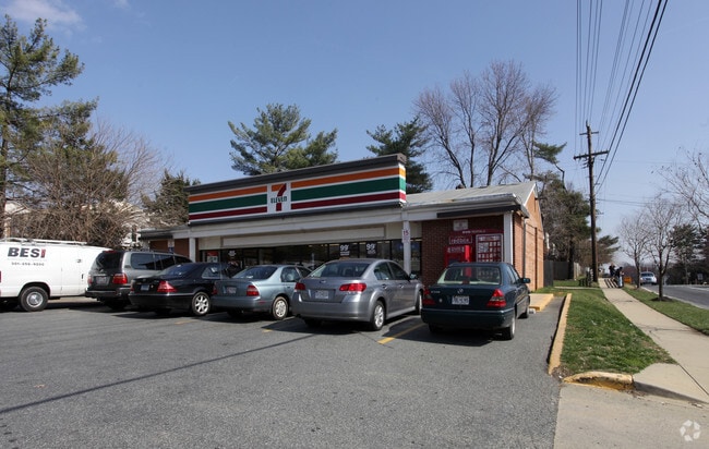
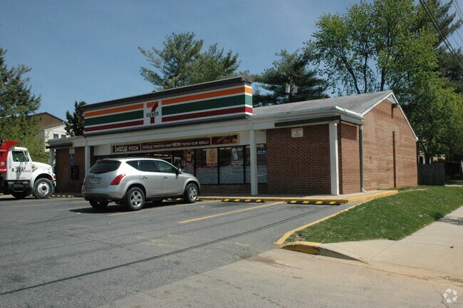
Property Record
17701 Muncaster Rd, Derwood, MD 20855

Property Detail
17701 Muncaster Rd
08-00715938
PARCEL A REDLAND
Storebuilding
Montgomery
CRT07
Maryland
B and X Area of moderate flood hazard, usually the area between the limits of the 100-year and 500-year floods.
0.35 AC
2024
North Rockville
2025
Washington, DC
701212
Washington-Arlington-Alexandria, DC-VA-MD-WV
3,102 SF
NEARBY LISTINGS FOR SALE OR LEASE
DEMOGRAPHICS near 17701 Muncaster Rd
1 mile
3 mile
5 mile
2025 Total Population
5,932
77,150
257,406
2030 Population
6,045
79,258
264,976
Pop Growth 2025-2030
+ 1.90%
+ 2.73%
+ 2.94%
Average Age
43
40
41
2025 Total Households
1,951
26,851
94,059
HH Growth 2025-2030
+ 1.69%
+ 2.79%
+ 2.96%
Median Household Inc
$148,203
$117,975
$115,941
Avg Household Size
2.90
2.80
2.70
2025 Avg HH Vehicles
2.00
2.00
2.00
Median Home Value
$678,793
$586,692
$565,217
Median Year Built
1976
1986
1983
Nearby Places
Map Layers
Map Styles
 Street
 Aerial
Layers
 Traffic
 Biking
Places
Listings with unknown addresses are not visible on the map
- Restaurants
- Banks
- Shops
- Fitness
- Groceries
PUBLIC TRANSPORTATION
COMMUTER RAIL
Drive
Walk
Distance
7 min
3.2 mi
Drive
Walk
Distance
8 min
3.6 mi
AIRPORT
Ronald Reagan Washington Ntl
Drive
Walk
Distance
Ronald Reagan Washington Ntl
48 min
26.9 mi
Washington Dulles International
Drive
Walk
Distance
Washington Dulles International
53 min
33.3 mi
Baltimore/Washington International Thurgood Marshall
Drive
Walk
Distance
Baltimore/Washington International Thurgood Marshall
51 min
36.4 mi
Freight Ports
Port of Baltimore
Drive
Walk
Distance
Port of Baltimore
54 min
39.0 mi
Nearby Properties
Address
Land Use
TOTAL SIZE
Lot Size
Zoning
Address
Land Use
TOTAL SIZE
Lot Size
Zoning
978,527 SF
11.54 AC
03
Address
Land Use
TOTAL SIZE
Lot Size
Zoning
431,178 SF
40.97 AC
RA
Address
Land Use
TOTAL SIZE
Lot Size
Zoning
185,000 SF
2.60 AC
EOF
Address
Land Use
TOTAL SIZE
Lot Size
Zoning
912,992 SF
6.11 AC
CBD
Address
Land Use
TOTAL SIZE
Lot Size
Zoning
754,379 SF
28.29 AC
R90
Address
Land Use
TOTAL SIZE
Lot Size
Zoning
185,040 SF
49.79 AC
IL1.0
Address
Land Use
TOTAL SIZE
Lot Size
Zoning
407,130 SF
4.62 AC
CRT1.
Address
Land Use
TOTAL SIZE
Lot Size
Zoning
363,000 SF
4.37 AC
MXTD
Address
Land Use
TOTAL SIZE
Lot Size
Zoning
899,156 SF
6.05 AC
CD
Address
Land Use
TOTAL SIZE
Lot Size
Zoning
325,990 SF
51.21 AC
CRT07
Address
Land Use
TOTAL SIZE
Lot Size
Zoning
316,883 SF
8.62 AC
OCPD
Address
Land Use
TOTAL SIZE
Lot Size
Zoning
565,209 SF
6.53 AC
MXD
Address
Land Use
TOTAL SIZE
Lot Size
Zoning
407,972 SF
44.95 AC
IL1.0
Address
Land Use
TOTAL SIZE
Lot Size
Zoning
230,460 SF
6.38 AC
03
Address
Land Use
TOTAL SIZE
Lot Size
Zoning
230,460 SF
6.36 AC
03
Address
Land Use
TOTAL SIZE
Lot Size
Zoning
128,884 SF
5.20 AC
CBD
Address
Land Use
TOTAL SIZE
Lot Size
Zoning
17 AC
R18
Address
Land Use
TOTAL SIZE
Lot Size
Zoning
295,478 SF
29.99 AC
RE1
Address
Land Use
TOTAL SIZE
Lot Size
Zoning
238,950 SF
9.03 AC
MXE
Address
Land Use
TOTAL SIZE
Lot Size
Zoning
241,764 SF
9.27 AC
R20
Address
Land Use
TOTAL SIZE
Lot Size
Zoning
330,041 SF
15.11 AC
EOF07
Address
Land Use
TOTAL SIZE
Lot Size
Zoning
119,858 SF
43.30 AC
RE1
Address
Land Use
TOTAL SIZE
Lot Size
Zoning
49,270 SF
43.12 AC
IM2.5
Address
Land Use
TOTAL SIZE
Lot Size
Zoning
182,289 SF
3.31 AC
MXE
Address
Land Use
TOTAL SIZE
Lot Size
Zoning
171,500 SF
12.94 AC
IM0.5
Address
Land Use
TOTAL SIZE
Lot Size
Zoning
20,289 SF
9.87 AC
MXD
Address
Land Use
TOTAL SIZE
Lot Size
Zoning
218,529 SF
12.52 AC
I3
Address
Land Use
TOTAL SIZE
Lot Size
Zoning
72,491 SF
TC03
Address
Land Use
TOTAL SIZE
Lot Size
Zoning
132,259 SF
41.20 AC
RA
Address
Land Use
TOTAL SIZE
Lot Size
Zoning
203,214 SF
17.63 AC
R30
The World's #1 Commercial Real Estate Marketplace
Connect with us
© 2026 CoStar Group
The information above has been obtained from sources believed reliable. While we do not doubt its accuracy we have not verified it and make no guarantee, warranty or representation about it. It is your responsibility to independently confirm its accuracy and completeness. Any projections, opinions, assumptions, or estimates used are for example only and do not represent the current or future performance of the property. The value of this transaction to you depends on tax and other factors which should be evaluated by your tax, financial, and legal advisors. You and your advisors should conduct a careful, independent investigation of the property to determine to your satisfaction the suitability of the property for your needs.