Property Record
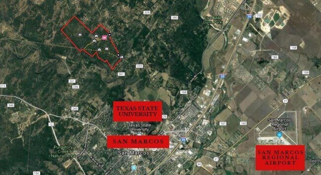
1775 Hilliard Rd, San Marcos, TX 78666


Property Detail
1775 Hilliard Rd
Austin-Round Rock-San Marcos, TX
A0084 ELIJAH CLARK SURVEY, TRACT PT 15, ACRES 674.803
R13252
HAYS
Pasture
Texas
A Areas with a 1% annual chance of flooding and a 26% chance of flooding over the life of a 30-year mortgage.
15
2024
674.80 AC
2025
Hays County
010704
Austin
3,600 SF
NEARBY LISTINGS FOR SALE OR LEASE
DEMOGRAPHICS near 1775 Hilliard Rd
1 mile
3 mile
5 mile
2024 Total Population
377
16,062
69,605
2029 Population
489
20,719
90,401
Pop Growth 2024-2029
+ 29.71%
+ 28.99%
+ 29.88%
Average Age
40
31
32
2024 Total Households
152
6,418
27,788
HH Growth 2024-2029
+ 30.26%
+ 31.80%
+ 31.57%
Median Household Inc
$44,999
$30,177
$33,351
Avg Household Size
2.40
2.20
2.30
2024 Avg HH Vehicles
2.00
2.00
2.00
Median Home Value
$369,999
$332,809
$292,319
Median Year Built
1996
1993
1996
Nearby Places
Map Layers
Map Styles
 Street
 Aerial
Transit
 Traffic
 Biking
Places
Listings with unknown addresses are not visible on the map
- Restaurants
- Banks
- Shops
- Fitness
- Groceries
PUBLIC TRANSPORTATION
COMMUTER RAIL
San Marcos Amtrak (Texas Eagle - Amtrak)
Drive
Walk
Distance
San Marcos Amtrak (Texas Eagle - Amtrak)
16 min
6.4 mi
AIRPORT
Austin-Bergstrom International
Drive
Walk
Distance
Austin-Bergstrom International
57 min
38.9 mi
Freight Ports
Calhoun Port
Drive
Walk
Distance
Calhoun Port
177 min
140.0 mi
SALE & LEASE HISTORY
LISTING DATE
SALE/LEASE

Feb 12, 2020
For Sale
Nearby Properties
Address
Land Use
TOTAL SIZE
Lot Size
Zoning
Address
Land Use
TOTAL SIZE
Lot Size
Zoning
402,983 SF
21.31 AC
Address
Land Use
TOTAL SIZE
Lot Size
Zoning
4,175 SF
3,380.82 AC
Address
Land Use
TOTAL SIZE
Lot Size
Zoning
343,094 SF
39.30 AC
Address
Land Use
TOTAL SIZE
Lot Size
Zoning
266,157 SF
14.70 AC
Address
Land Use
TOTAL SIZE
Lot Size
Zoning
181,400 SF
13.07 AC
Address
Land Use
TOTAL SIZE
Lot Size
Zoning
140,844 SF
17.05 AC
Address
Land Use
TOTAL SIZE
Lot Size
Zoning
171,536 SF
8.49 AC
Address
Land Use
TOTAL SIZE
Lot Size
Zoning
140,866 SF
10.08 AC
Address
Land Use
TOTAL SIZE
Lot Size
Zoning
70,340 SF
8.36 AC
Address
Land Use
TOTAL SIZE
Lot Size
Zoning
118,304 SF
4.07 AC
Address
Land Use
TOTAL SIZE
Lot Size
Zoning
86,998 SF
4.55 AC
Address
Land Use
TOTAL SIZE
Lot Size
Zoning
101,657 SF
5.17 AC
Address
Land Use
TOTAL SIZE
Lot Size
Zoning
185.93 AC
Address
Land Use
TOTAL SIZE
Lot Size
Zoning
45,732 SF
2.35 AC
Address
Land Use
TOTAL SIZE
Lot Size
Zoning
15,736 SF
1.46 AC
Address
Land Use
TOTAL SIZE
Lot Size
Zoning
Address
Land Use
TOTAL SIZE
Lot Size
Zoning
7,140 SF
3.30 AC
Address
Land Use
TOTAL SIZE
Lot Size
Zoning
56,976 SF
5.80 AC
Address
Land Use
TOTAL SIZE
Lot Size
Zoning
22,237 SF
19.72 AC
Address
Land Use
TOTAL SIZE
Lot Size
Zoning
249.19 AC
Address
Land Use
TOTAL SIZE
Lot Size
Zoning
40,376 SF
1.37 AC
Address
Land Use
TOTAL SIZE
Lot Size
Zoning
20,450 SF
15 AC
Address
Land Use
TOTAL SIZE
Lot Size
Zoning
55,460 SF
2.41 AC
Address
Land Use
TOTAL SIZE
Lot Size
Zoning
3,459 SF
19.41 AC
Address
Land Use
TOTAL SIZE
Lot Size
Zoning
23,840 SF
1.11 AC
Address
Land Use
TOTAL SIZE
Lot Size
Zoning
20,383 SF
1.19 AC
Address
Land Use
TOTAL SIZE
Lot Size
Zoning
Address
Land Use
TOTAL SIZE
Lot Size
Zoning
64.77 AC
Address
Land Use
TOTAL SIZE
Lot Size
Zoning
14,675 SF
2.37 AC
Address
Land Use
TOTAL SIZE
Lot Size
Zoning
20,487 SF
0.72 AC
The World's #1 Commercial Real Estate Marketplace
Connect with us
© 2026 CoStar Group
The information above has been obtained from sources believed reliable. While we do not doubt its accuracy we have not verified it and make no guarantee, warranty or representation about it. It is your responsibility to independently confirm its accuracy and completeness. Any projections, opinions, assumptions, or estimates used are for example only and do not represent the current or future performance of the property. The value of this transaction to you depends on tax and other factors which should be evaluated by your tax, financial, and legal advisors. You and your advisors should conduct a careful, independent investigation of the property to determine to your satisfaction the suitability of the property for your needs.