Property Record
17771 W Us 380 W, Ponder, TX 76259

Property Detail
17771 W Us 380 W
Dallas-Fort Worth-Arlington, TX
STONY VILLAGE BLK A LOT 3
R221731
DENTON
Vacantlandnec
Texas
A Areas with a 1% annual chance of flooding and a 26% chance of flooding over the life of a 30-year mortgage.
3
2024
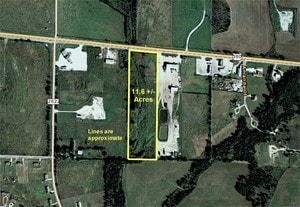
11.61 AC
2025
Outlying Denton County
020313
Dallas/Ft Worth
9,000 SF
NEARBY LISTINGS FOR SALE OR LEASE
DEMOGRAPHICS near 17771 W Us 380 W
1 mile
3 mile
5 mile
2025 Total Population
1,100
2,722
6,045
2030 Population
1,290
3,140
6,885
Pop Growth 2025-2030
+ 17.27%
+ 15.36%
+ 13.90%
Average Age
40
41
41
2025 Total Households
377
923
2,048
HH Growth 2025-2030
+ 17.51%
+ 15.60%
+ 14.11%
Median Household Inc
$96,982
$117,441
$114,173
Avg Household Size
2.90
2.90
2.90
2025 Avg HH Vehicles
3.00
3.00
3.00
Median Home Value
$696,335
$657,258
$581,938
Median Year Built
2007
2005
2002
Nearby Places
Map Layers
Map Styles
 Street
 Aerial
Layers
 Traffic
 Biking
Places
Listings with unknown addresses are not visible on the map
- Restaurants
- Banks
- Shops
- Fitness
- Groceries
PUBLIC TRANSPORTATION
AIRPORT
Dallas-Fort Worth International
Drive
Walk
Distance
Dallas-Fort Worth International
48 min
39.5 mi
Dallas Love Field
Drive
Walk
Distance
Dallas Love Field
60 min
48.6 mi
Nearby Properties
Address
Land Use
TOTAL SIZE
Lot Size
Zoning
Address
Land Use
TOTAL SIZE
Lot Size
Zoning
23,082 SF
4 AC
Address
Land Use
TOTAL SIZE
Lot Size
Zoning
336 SF
28.59 AC
Address
Land Use
TOTAL SIZE
Lot Size
Zoning
60,000 SF
7.36 AC
Address
Land Use
TOTAL SIZE
Lot Size
Zoning
48,400 SF
10.30 AC
Address
Land Use
TOTAL SIZE
Lot Size
Zoning
146.99 AC
Address
Land Use
TOTAL SIZE
Lot Size
Zoning
9,258 SF
4 AC
Address
Land Use
TOTAL SIZE
Lot Size
Zoning
6,450 SF
17.63 AC
Address
Land Use
TOTAL SIZE
Lot Size
Zoning
5,500 SF
12.65 AC
Address
Land Use
TOTAL SIZE
Lot Size
Zoning
16,250 SF
6.89 AC
Address
Land Use
TOTAL SIZE
Lot Size
Zoning
25,175 SF
7.98 AC
Address
Land Use
TOTAL SIZE
Lot Size
Zoning
1,080 SF
70.74 AC
Address
Land Use
TOTAL SIZE
Lot Size
Zoning
10.93 AC
Address
Land Use
TOTAL SIZE
Lot Size
Zoning
8,435 SF
9.05 AC
Address
Land Use
TOTAL SIZE
Lot Size
Zoning
4,558 SF
4.81 AC
Address
Land Use
TOTAL SIZE
Lot Size
Zoning
1,064 SF
58.20 AC
Address
Land Use
TOTAL SIZE
Lot Size
Zoning
18,200 SF
10.03 AC
Address
Land Use
TOTAL SIZE
Lot Size
Zoning
7,200 SF
2.05 AC
Address
Land Use
TOTAL SIZE
Lot Size
Zoning
3,367 SF
8 AC
Address
Land Use
TOTAL SIZE
Lot Size
Zoning
3,374 SF
10 AC
Address
Land Use
TOTAL SIZE
Lot Size
Zoning
5,719 SF
30 AC
Address
Land Use
TOTAL SIZE
Lot Size
Zoning
7,875 SF
3.96 AC
Address
Land Use
TOTAL SIZE
Lot Size
Zoning
6,477 SF
33.08 AC
Address
Land Use
TOTAL SIZE
Lot Size
Zoning
6,205 SF
9.85 AC
Address
Land Use
TOTAL SIZE
Lot Size
Zoning
4,368 SF
0.71 AC
Address
Land Use
TOTAL SIZE
Lot Size
Zoning
600 SF
6.89 AC
Address
Land Use
TOTAL SIZE
Lot Size
Zoning
1,925 SF
4.97 AC
Address
Land Use
TOTAL SIZE
Lot Size
Zoning
6.89 AC
Address
Land Use
TOTAL SIZE
Lot Size
Zoning
63,025 SF
10 AC
The World's #1 Commercial Real Estate Marketplace
Connect with us
© 2026 CoStar Group
The information above has been obtained from sources believed reliable. While we do not doubt its accuracy we have not verified it and make no guarantee, warranty or representation about it. It is your responsibility to independently confirm its accuracy and completeness. Any projections, opinions, assumptions, or estimates used are for example only and do not represent the current or future performance of the property. The value of this transaction to you depends on tax and other factors which should be evaluated by your tax, financial, and legal advisors. You and your advisors should conduct a careful, independent investigation of the property to determine to your satisfaction the suitability of the property for your needs.