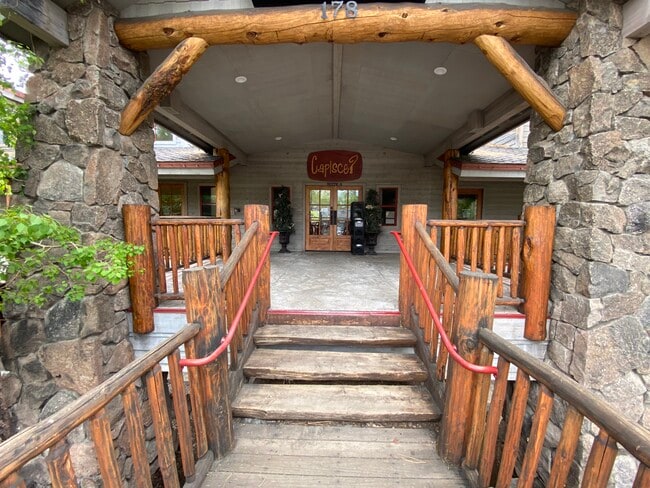
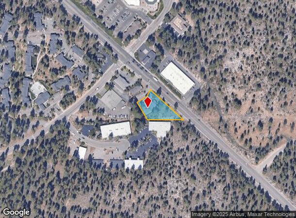
Property Record
178 Highway 50, Stateline, NV 89449

NEARBY LISTINGS FOR SALE OR LEASE
Property Detail
178 Highway 50
Gardnerville Ranchos, NV
Record Of Survey Map
1318-15-804-008
LOT B
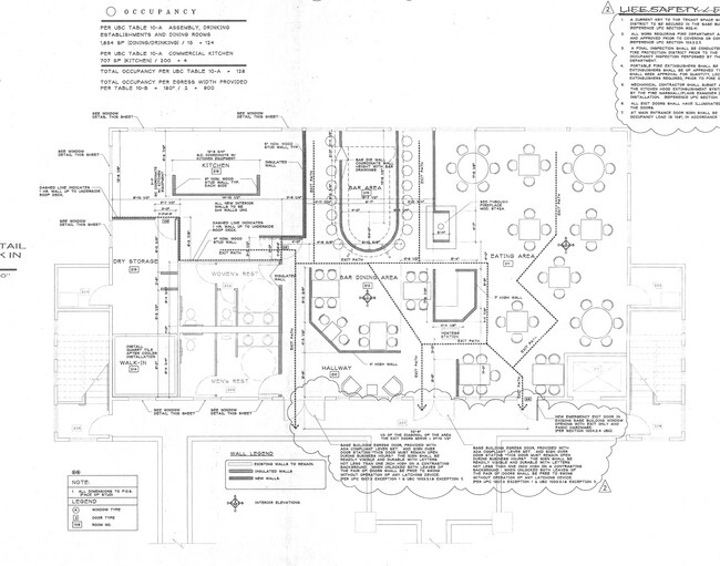
Officebuilding
Douglas
X
Nevada
06003C0025B
b
2024
0.65 AC
2025
Douglas County
001800
Reno/Sparks
6,936 SF
DEMOGRAPHICS near 178 Highway 50
1 Mile
3 Mile
5 Mile
2024 Total Population
1,274
7,925
19,045
2029 Population
1,244
7,691
19,145
Pop Growth 2024-2029
(2.35%)
(2.95%)
+ 0.53%
Average Age
44
43
42
2024 Total Households
623
3,600
8,375
HH Growth 2024-2029
(2.41%)
(3.00%)
+ 0.41%
Median Household Inc
$74,492
$67,809
$69,760
Avg Household Size
2.00
2.20
2.20
2024 Avg HH Vehicles
2.00
2.00
2.00
Median Home Value
$892,307
$853,023
$745,619
Median Year Built
1973
1973
1972
Nearby Places
- Restaurants
- Banks
- Shops
- Fitness
- Groceries
SALE & LEASE HISTORY
LISTING DATE
SALE/LEASE

Sep 12, 2024
For Lease
Nearby Properties
Address
Land Use
TOTAL SIZE
Lot Size
Zoning
Address
Land Use
TOTAL SIZE
Lot Size
Zoning
3.58 AC
GC
Address
Land Use
TOTAL SIZE
Lot Size
Zoning
991,973 SF
5.14 AC
Address
Land Use
TOTAL SIZE
Lot Size
Zoning
1,230,269 SF
21.35 AC
Address
Land Use
TOTAL SIZE
Lot Size
Zoning
2.42 AC
TC
Address
Land Use
TOTAL SIZE
Lot Size
Zoning
892,616 SF
17.22 AC
Address
Land Use
TOTAL SIZE
Lot Size
Zoning
112,020 SF
7.61 AC
GC
Address
Land Use
TOTAL SIZE
Lot Size
Zoning
153,774 SF
14.31 AC
GC
Address
Land Use
TOTAL SIZE
Lot Size
Zoning
52,708 SF
1.21 AC
GC
Address
Land Use
TOTAL SIZE
Lot Size
Zoning
52,000 SF
2.17 AC
TC
Address
Land Use
TOTAL SIZE
Lot Size
Zoning
845,731 SF
20.83 AC
Address
Land Use
TOTAL SIZE
Lot Size
Zoning
4,946 SF
0.52 AC
TC
Address
Land Use
TOTAL SIZE
Lot Size
Zoning
52,304 SF
23.58 AC
Address
Land Use
TOTAL SIZE
Lot Size
Zoning
108,074 SF
4.91 AC
Address
Land Use
TOTAL SIZE
Lot Size
Zoning
1,334 SF
124.88 AC
Address
Land Use
TOTAL SIZE
Lot Size
Zoning
38,492 SF
1.71 AC
Address
Land Use
TOTAL SIZE
Lot Size
Zoning
Address
Land Use
TOTAL SIZE
Lot Size
Zoning
25,089 SF
3.09 AC
Address
Land Use
TOTAL SIZE
Lot Size
Zoning
22,770 SF
0.55 AC
GC
Address
Land Use
TOTAL SIZE
Lot Size
Zoning
29,418 SF
210.26 AC
Address
Land Use
TOTAL SIZE
Lot Size
Zoning
24.28 AC
Address
Land Use
TOTAL SIZE
Lot Size
Zoning
12,897 SF
18.94 AC
Address
Land Use
TOTAL SIZE
Lot Size
Zoning
832,974 SF
12.85 AC
Address
Land Use
TOTAL SIZE
Lot Size
Zoning
36,908 SF
24.30 AC
Address
Land Use
TOTAL SIZE
Lot Size
Zoning
29,507 SF
1.38 AC
SLT
Address
Land Use
TOTAL SIZE
Lot Size
Zoning
12,720 SF
0.31 AC
GC
Address
Land Use
TOTAL SIZE
Lot Size
Zoning
31,132 SF
0.31 AC
TC
Address
Land Use
TOTAL SIZE
Lot Size
Zoning
14,900 SF
0.69 AC
TC
Address
Land Use
TOTAL SIZE
Lot Size
Zoning
10,876 SF
0.25 AC
GC
The World's #1 Commercial Real Estate Marketplace
Connect with us
© 2025 CoStar Group
The information above has been obtained from sources believed reliable. While we do not doubt its accuracy we have not verified it and make no guarantee, warranty or representation about it. It is your responsibility to independently confirm its accuracy and completeness. Any projections, opinions, assumptions, or estimates used are for example only and do not represent the current or future performance of the property. The value of this transaction to you depends on tax and other factors which should be evaluated by your tax, financial, and legal advisors. You and your advisors should conduct a careful, independent investigation of the property to determine to your satisfaction the suitability of the property for your needs.