Property Record
1784 Steel St, Louisville, CO 80027

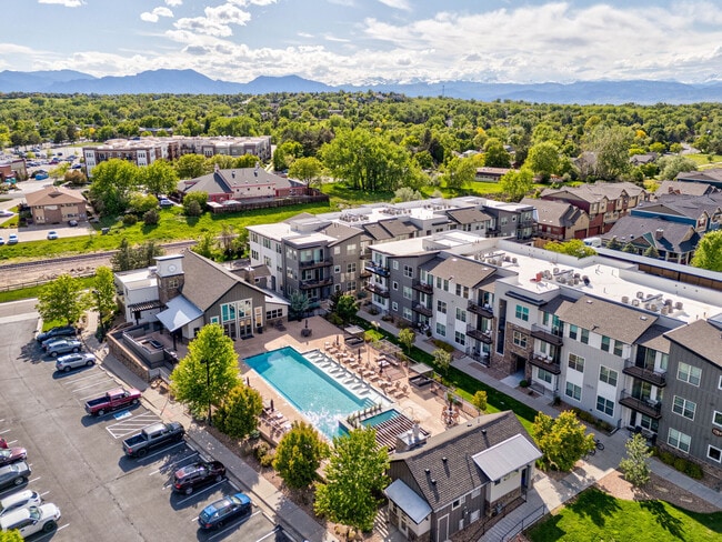

Property Detail
1784 Steel St
Boulder, CO
LOT 1 BLK 1 STEEL RANCH SOUTH
1575054-63-001
BOULDER
Multifamilydwelling
Colorado
B and X Area of moderate flood hazard, usually the area between the limits of the 100-year and 500-year floods.
1
2023
6.70 AC
2025
Southwest Boulder County
013003
Denver
214,285 SF
NEARBY LISTINGS FOR SALE OR LEASE
DEMOGRAPHICS near 1784 Steel St
1 mile
3 mile
5 mile
2025 Total Population
12,400
54,636
104,375
2030 Population
12,350
54,565
105,658
Pop Growth 2025-2030
(0.40%)
(0.13%)
+ 1.23%
Average Age
43
42
42
2025 Total Households
5,191
21,961
42,036
HH Growth 2025-2030
(0.42%)
(0.10%)
+ 1.51%
Median Household Inc
$126,364
$121,921
$120,719
Avg Household Size
2.30
2.40
2.40
2025 Avg HH Vehicles
2.00
2.00
2.00
Median Home Value
$822,145
$804,419
$795,667
Median Year Built
1992
1991
1995
Nearby Places
Map Layers
Map Styles
 Street
 Aerial
Transit
 Traffic
 Biking
Places
Listings with unknown addresses are not visible on the map
- Restaurants
- Banks
- Shops
- Fitness
- Groceries
PUBLIC TRANSPORTATION
AIRPORT
Denver International
Drive
Walk
Distance
Denver International
42 min
35.6 mi
Freight Ports
Tulsa Port Of Catoosa
Drive
Walk
Distance
Tulsa Port Of Catoosa
748 min
729.7 mi
Nearby Properties
Address
Land Use
TOTAL SIZE
Lot Size
Zoning
Address
Land Use
TOTAL SIZE
Lot Size
Zoning
420,330 SF
41.96 AC
A
Address
Land Use
TOTAL SIZE
Lot Size
Zoning
62.60 AC
Address
Land Use
TOTAL SIZE
Lot Size
Zoning
411,485 SF
24.79 AC
Address
Land Use
TOTAL SIZE
Lot Size
Zoning
188,092 SF
2.01 AC
Address
Land Use
TOTAL SIZE
Lot Size
Zoning
167,000 SF
20.32 AC
Address
Land Use
TOTAL SIZE
Lot Size
Zoning
86.39 AC
Address
Land Use
TOTAL SIZE
Lot Size
Zoning
120,510 SF
11.02 AC
Address
Land Use
TOTAL SIZE
Lot Size
Zoning
111.14 AC
ER
Address
Land Use
TOTAL SIZE
Lot Size
Zoning
153,430 SF
12.16 AC
Address
Land Use
TOTAL SIZE
Lot Size
Zoning
137,435 SF
9.49 AC
Address
Land Use
TOTAL SIZE
Lot Size
Zoning
214,678 SF
10.46 AC
Address
Land Use
TOTAL SIZE
Lot Size
Zoning
113,473 SF
8.59 AC
Address
Land Use
TOTAL SIZE
Lot Size
Zoning
165,172 SF
11.12 AC
Address
Land Use
TOTAL SIZE
Lot Size
Zoning
135,508 SF
9.64 AC
Address
Land Use
TOTAL SIZE
Lot Size
Zoning
164,842 SF
10.97 AC
Address
Land Use
TOTAL SIZE
Lot Size
Zoning
74.45 AC
RR
Address
Land Use
TOTAL SIZE
Lot Size
Zoning
109,056 SF
7.76 AC
Address
Land Use
TOTAL SIZE
Lot Size
Zoning
207,248 SF
15.66 AC
Address
Land Use
TOTAL SIZE
Lot Size
Zoning
76,658 SF
6.40 AC
Address
Land Use
TOTAL SIZE
Lot Size
Zoning
67,551 SF
4.27 AC
Address
Land Use
TOTAL SIZE
Lot Size
Zoning
130,348 SF
8.88 AC
Address
Land Use
TOTAL SIZE
Lot Size
Zoning
91,570 SF
6.09 AC
Address
Land Use
TOTAL SIZE
Lot Size
Zoning
136,448 SF
10.86 AC
Address
Land Use
TOTAL SIZE
Lot Size
Zoning
247,609 SF
14.53 AC
Address
Land Use
TOTAL SIZE
Lot Size
Zoning
46.05 AC
Address
Land Use
TOTAL SIZE
Lot Size
Zoning
308,482 SF
16.27 AC
B-PUD
Address
Land Use
TOTAL SIZE
Lot Size
Zoning
109,547 SF
7.91 AC
Address
Land Use
TOTAL SIZE
Lot Size
Zoning
273,678 SF
10.79 AC
Address
Land Use
TOTAL SIZE
Lot Size
Zoning
178,995 SF
5.93 AC
Address
Land Use
TOTAL SIZE
Lot Size
Zoning
83,615 SF
6.81 AC
The World's #1 Commercial Real Estate Marketplace
Connect with us
© 2026 CoStar Group
The information above has been obtained from sources believed reliable. While we do not doubt its accuracy we have not verified it and make no guarantee, warranty or representation about it. It is your responsibility to independently confirm its accuracy and completeness. Any projections, opinions, assumptions, or estimates used are for example only and do not represent the current or future performance of the property. The value of this transaction to you depends on tax and other factors which should be evaluated by your tax, financial, and legal advisors. You and your advisors should conduct a careful, independent investigation of the property to determine to your satisfaction the suitability of the property for your needs.