Property Record
609 S 104Th St, Louisville, CO 80027

Save to a Folder
{{folder.Name}}
{{folder.ListingIds.length}} Properties
{{folder.ListingIds.length}} Property
Create a New Folder
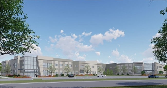
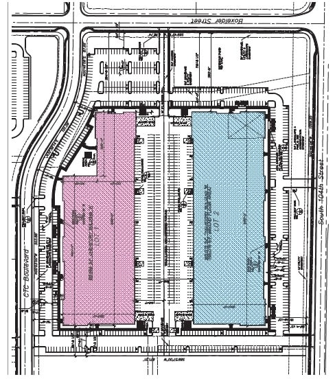
Property Detail
609 S 104Th St
Boulder, CO
LOT 2 COLORADO TECH CENTER FLG 2 RPLT C
1575160-38-002
Boulder
Warehouse
Colorado
B and X Area of moderate flood hazard, usually the area between the limits of the 100-year and 500-year floods.
2
2025
10.97 AC
2026
Boulder County
060700
Denver
164,842 SF
NEARBY LISTINGS FOR SALE OR LEASE
DEMOGRAPHICS near 609 S 104Th St
1 mile
3 mile
5 mile
2025 Total Population
753
67,399
148,662
2030 Population
751
68,256
151,405
Pop Growth 2025-2030
(0.27%)
+ 1.27%
+ 1.85%
Average Age
41
41
41
2025 Total Households
271
28,183
59,400
HH Growth 2025-2030
(0.37%)
+ 1.59%
+ 2.13%
Median Household Inc
$141,964
$109,324
$118,473
Avg Household Size
2.70
2.30
2.50
2025 Avg HH Vehicles
2.00
2.00
2.00
Median Home Value
$798,387
$748,889
$753,232
Median Year Built
1994
1993
1996
Nearby Places
Map Layers
Map Styles
 Street
 Aerial
Layers
 Traffic
 Biking
Places
Listings with unknown addresses are not visible on the map
- Restaurants
- Banks
- Shops
- Fitness
- Groceries
PUBLIC TRANSPORTATION
AIRPORT
Denver International
Drive
Walk
Distance
Denver International
37 min
31.7 mi
SALE & LEASE HISTORY
LISTING DATE
SALE/LEASE

Jul 26, 2018
For Lease
Nearby Properties
Address
Land Use
TOTAL SIZE
Lot Size
Zoning
Address
Land Use
TOTAL SIZE
Lot Size
Zoning
776,625 SF
41.29 AC
PUD
Address
Land Use
TOTAL SIZE
Lot Size
Zoning
420,330 SF
41.96 AC
A
Address
Land Use
TOTAL SIZE
Lot Size
Zoning
62.60 AC
Address
Land Use
TOTAL SIZE
Lot Size
Zoning
305,331 SF
14.41 AC
PUD
Address
Land Use
TOTAL SIZE
Lot Size
Zoning
279.72 AC
A
Address
Land Use
TOTAL SIZE
Lot Size
Zoning
254,500 SF
13.42 AC
PUD
Address
Land Use
TOTAL SIZE
Lot Size
Zoning
188,092 SF
2.01 AC
Address
Land Use
TOTAL SIZE
Lot Size
Zoning
233.17 AC
A
Address
Land Use
TOTAL SIZE
Lot Size
Zoning
187,920 SF
10.57 AC
PUD
Address
Land Use
TOTAL SIZE
Lot Size
Zoning
22.16 AC
Address
Land Use
TOTAL SIZE
Lot Size
Zoning
453,015 SF
12.10 AC
B-PUD
Address
Land Use
TOTAL SIZE
Lot Size
Zoning
320,771 SF
18.60 AC
PUD
Address
Land Use
TOTAL SIZE
Lot Size
Zoning
120,510 SF
11.02 AC
Address
Land Use
TOTAL SIZE
Lot Size
Zoning
446,461 SF
18.19 AC
B-PUD
Address
Land Use
TOTAL SIZE
Lot Size
Zoning
186,744 SF
10.46 AC
Address
Land Use
TOTAL SIZE
Lot Size
Zoning
117.98 AC
Address
Land Use
TOTAL SIZE
Lot Size
Zoning
165,172 SF
11.12 AC
Address
Land Use
TOTAL SIZE
Lot Size
Zoning
308,832 SF
11.91 AC
PUD
Address
Land Use
TOTAL SIZE
Lot Size
Zoning
153,430 SF
12.16 AC
Address
Land Use
TOTAL SIZE
Lot Size
Zoning
116.21 AC
A
Address
Land Use
TOTAL SIZE
Lot Size
Zoning
280,447 SF
5.98 AC
PUD
Address
Land Use
TOTAL SIZE
Lot Size
Zoning
135,508 SF
9.64 AC
Address
Land Use
TOTAL SIZE
Lot Size
Zoning
493,314 SF
27.58 AC
Address
Land Use
TOTAL SIZE
Lot Size
Zoning
17.81 AC
Address
Land Use
TOTAL SIZE
Lot Size
Zoning
137,435 SF
9.49 AC
Address
Land Use
TOTAL SIZE
Lot Size
Zoning
203,755 SF
39.65 AC
R-1
Address
Land Use
TOTAL SIZE
Lot Size
Zoning
207,248 SF
15.66 AC
Address
Land Use
TOTAL SIZE
Lot Size
Zoning
18.77 AC
A
Address
Land Use
TOTAL SIZE
Lot Size
Zoning
347,150 SF
19.51 AC
PUD
The World's #1 Commercial Real Estate Marketplace
Connect with us
© 2026 CoStar Group
The information above has been obtained from sources believed reliable. While we do not doubt its accuracy we have not verified it and make no guarantee, warranty or representation about it. It is your responsibility to independently confirm its accuracy and completeness. Any projections, opinions, assumptions, or estimates used are for example only and do not represent the current or future performance of the property. The value of this transaction to you depends on tax and other factors which should be evaluated by your tax, financial, and legal advisors. You and your advisors should conduct a careful, independent investigation of the property to determine to your satisfaction the suitability of the property for your needs.