Property Record
1785 E Main St, Dothan, AL 36301


Save to a Folder
{{folder.Name}}
{{folder.ListingIds.length}} Properties
{{folder.ListingIds.length}} Property
Create a New Folder
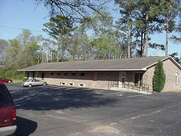
Property Detail
1785 E Main St
10-04-20-3-002-009-000
BEG AT NW COR OF SW4 OF S20 T3 R27
Officebuilding
Houston
B and X Area of moderate flood hazard, usually the area between the limits of the 100-year and 500-year floods.
Alabama
2025
0.97 AC
2025
Dothan/Enterprise
041400
Other Market Areas
20,300 SF
Dothan, AL
NEARBY LISTINGS FOR SALE OR LEASE
DEMOGRAPHICS near 1785 E Main St
1 mile
3 mile
5 mile
2025 Total Population
3,938
29,279
55,474
2030 Population
3,994
29,812
56,420
Pop Growth 2025-2030
+ 1.42%
+ 1.82%
+ 1.71%
Average Age
39
39
40
2025 Total Households
1,564
12,152
23,354
HH Growth 2025-2030
+ 1.53%
+ 1.91%
+ 1.75%
Median Household Inc
$33,939
$37,868
$46,988
Avg Household Size
2.40
2.30
2.30
2025 Avg HH Vehicles
2.00
2.00
2.00
Median Home Value
$79,220
$130,959
$167,556
Median Year Built
1972
1971
1977
Nearby Places
Map Layers
Map Styles
 Street
 Aerial
Layers
 Traffic
 Biking
Places
Listings with unknown addresses are not visible on the map
- Restaurants
- Banks
- Shops
- Fitness
- Groceries
PUBLIC TRANSPORTATION
AIRPORT
Dothan Regional
Drive
Walk
Distance
Dothan Regional
19 min
11.4 mi
Freight Ports
Port of Panama City
Drive
Walk
Distance
Port of Panama City
113 min
86.6 mi
SALE & LEASE HISTORY
LISTING DATE
SALE/LEASE

Sep 25, 2016
For Lease
Sep 25, 2016
For Lease
Sep 24, 2016
For Sale
Nearby Properties
Address
Land Use
TOTAL SIZE
Lot Size
Zoning
Address
Land Use
TOTAL SIZE
Lot Size
Zoning
3,955 SF
19.20 AC
Address
Land Use
TOTAL SIZE
Lot Size
Zoning
1,800 SF
21.49 AC
Address
Land Use
TOTAL SIZE
Lot Size
Zoning
7,198 SF
Address
Land Use
TOTAL SIZE
Lot Size
Zoning
39,500 SF
1.97 AC
Address
Land Use
TOTAL SIZE
Lot Size
Zoning
88,725 SF
17 AC
Address
Land Use
TOTAL SIZE
Lot Size
Zoning
7,749 SF
17.70 AC
Address
Land Use
TOTAL SIZE
Lot Size
Zoning
900 SF
38 AC
Address
Land Use
TOTAL SIZE
Lot Size
Zoning
3,213 SF
12.66 AC
Address
Land Use
TOTAL SIZE
Lot Size
Zoning
460 SF
3.90 AC
Address
Land Use
TOTAL SIZE
Lot Size
Zoning
900 SF
12.03 AC
Address
Land Use
TOTAL SIZE
Lot Size
Zoning
90,918 SF
0.88 AC
Address
Land Use
TOTAL SIZE
Lot Size
Zoning
1,700 SF
3.49 AC
Address
Land Use
TOTAL SIZE
Lot Size
Zoning
25,300 SF
1.24 AC
Address
Land Use
TOTAL SIZE
Lot Size
Zoning
19,239 SF
16 AC
Address
Land Use
TOTAL SIZE
Lot Size
Zoning
72,200 SF
2.89 AC
Address
Land Use
TOTAL SIZE
Lot Size
Zoning
24,352 SF
5.34 AC
Address
Land Use
TOTAL SIZE
Lot Size
Zoning
176 SF
8.46 AC
Address
Land Use
TOTAL SIZE
Lot Size
Zoning
83,068 SF
3.84 AC
Address
Land Use
TOTAL SIZE
Lot Size
Zoning
15,000 SF
5.26 AC
Address
Land Use
TOTAL SIZE
Lot Size
Zoning
175,000 SF
5.13 AC
Address
Land Use
TOTAL SIZE
Lot Size
Zoning
400,000 SF
5.88 AC
Address
Land Use
TOTAL SIZE
Lot Size
Zoning
180 SF
3.65 AC
Address
Land Use
TOTAL SIZE
Lot Size
Zoning
69,000 SF
6.53 AC
Address
Land Use
TOTAL SIZE
Lot Size
Zoning
121,900 SF
5.20 AC
Address
Land Use
TOTAL SIZE
Lot Size
Zoning
61,200 SF
Address
Land Use
TOTAL SIZE
Lot Size
Zoning
174,000 SF
7.48 AC
Address
Land Use
TOTAL SIZE
Lot Size
Zoning
81,530 SF
10.80 AC
Address
Land Use
TOTAL SIZE
Lot Size
Zoning
150,056 SF
9.43 AC
Address
Land Use
TOTAL SIZE
Lot Size
Zoning
71,000 SF
2.85 AC
Address
Land Use
TOTAL SIZE
Lot Size
Zoning
35,700 SF
2.61 AC
The World's #1 Commercial Real Estate Marketplace
Connect with us
© 2026 CoStar Group
The information above has been obtained from sources believed reliable. While we do not doubt its accuracy we have not verified it and make no guarantee, warranty or representation about it. It is your responsibility to independently confirm its accuracy and completeness. Any projections, opinions, assumptions, or estimates used are for example only and do not represent the current or future performance of the property. The value of this transaction to you depends on tax and other factors which should be evaluated by your tax, financial, and legal advisors. You and your advisors should conduct a careful, independent investigation of the property to determine to your satisfaction the suitability of the property for your needs.