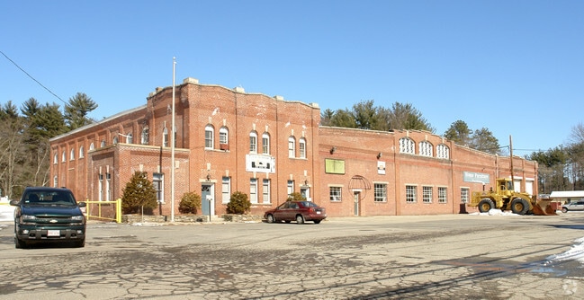
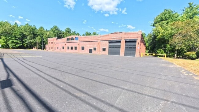
Property Record
7 King St, Salem, NH 03079
NEARBY LISTINGS FOR SALE OR LEASE
Property Detail
7 King St
SLEM-000117-008951-000008
Kings Court
Condominium
Rockingham
X
New Hampshire
25009C0075F
8
2024
0.04 AC
2024
Rockingham
100200
Boston
788 SF
Boston-Cambridge-Newton, MA-NH
DEMOGRAPHICS near 7 King St
1 mile
3 mile
5 mile
2024 Total Population
6,109
31,218
88,232
2029 Population
6,444
32,447
89,752
Pop Growth 2024-2029
+ 5.48%
+ 3.94%
+ 1.72%
Average Age
47
44
42
2024 Total Households
2,771
12,401
33,077
HH Growth 2024-2029
+ 5.67%
+ 4.11%
+ 1.76%
Median Household Inc
$94,534
$104,604
$104,321
Avg Household Size
2.20
2.50
2.60
2024 Avg HH Vehicles
2.00
2.00
2.00
Median Home Value
$376,428
$428,428
$446,257
Median Year Built
1977
1979
1977
Nearby Places
Map Layers
Map Styles
 Street
 Aerial
Transit
 Traffic
 Biking
Places
Listings with unknown addresses are not visible on the map
- Restaurants
- Banks
- Shops
- Fitness
- Groceries
PUBLIC TRANSPORTATION
AIRPORT
Manchester Boston Regional
Drive
Walk
Distance
Manchester Boston Regional
35 min
19.6 mi
Portsmouth International at Pease
Drive
Walk
Distance
Portsmouth International at Pease
59 min
40.0 mi
Freight Ports
Port of Boston
Drive
Walk
Distance
Port of Boston
56 min
39.6 mi
SALE & LEASE HISTORY
LISTING DATE
SALE/LEASE

Oct 15, 2025
For Lease
Aug 28, 2018
For Sale
Nearby Properties
Address
Land Use
TOTAL SIZE
Lot Size
Zoning
Address
Land Use
TOTAL SIZE
Lot Size
Zoning
72.18 AC
CIB
Address
Land Use
TOTAL SIZE
Lot Size
Zoning
297,592 SF
2.90 AC
CIC
Address
Land Use
TOTAL SIZE
Lot Size
Zoning
7.99 AC
CIB
Address
Land Use
TOTAL SIZE
Lot Size
Zoning
215,338 SF
66.52 AC
CIB
Address
Land Use
TOTAL SIZE
Lot Size
Zoning
55,819 SF
382.76 AC
RR2SCR
Address
Land Use
TOTAL SIZE
Lot Size
Zoning
21,433 SF
7.54 AC
LID
Address
Land Use
TOTAL SIZE
Lot Size
Zoning
59,565 SF
41.20 AC
RD
Address
Land Use
TOTAL SIZE
Lot Size
Zoning
46,991 SF
5.68 AC
CIB
Address
Land Use
TOTAL SIZE
Lot Size
Zoning
19,920 SF
15 AC
PBT
Address
Land Use
TOTAL SIZE
Lot Size
Zoning
8.24 AC
CIB
Address
Land Use
TOTAL SIZE
Lot Size
Zoning
56,632 SF
14.20 AC
RUR
Address
Land Use
TOTAL SIZE
Lot Size
Zoning
231.50 AC
B-RES
Address
Land Use
TOTAL SIZE
Lot Size
Zoning
3,602 SF
7.45 AC
RD
Address
Land Use
TOTAL SIZE
Lot Size
Zoning
4.06 AC
CIB
Address
Land Use
TOTAL SIZE
Lot Size
Zoning
320 SF
13.40 AC
RUR
Address
Land Use
TOTAL SIZE
Lot Size
Zoning
12,547 SF
120.40 AC
RD
Address
Land Use
TOTAL SIZE
Lot Size
Zoning
12,094 SF
5.57 AC
RD
Address
Land Use
TOTAL SIZE
Lot Size
Zoning
71,420 SF
18.50 AC
C2 C
Address
Land Use
TOTAL SIZE
Lot Size
Zoning
40,000 SF
7.53 AC
CDA
Address
Land Use
TOTAL SIZE
Lot Size
Zoning
23,964 SF
12.47 AC
MZ
Address
Land Use
TOTAL SIZE
Lot Size
Zoning
3,616 SF
17.77 AC
GC4
Address
Land Use
TOTAL SIZE
Lot Size
Zoning
42,720 SF
5.27 AC
LID
Address
Land Use
TOTAL SIZE
Lot Size
Zoning
26,262 SF
3.75 AC
CDA
Address
Land Use
TOTAL SIZE
Lot Size
Zoning
5.85 AC
CIB
Address
Land Use
TOTAL SIZE
Lot Size
Zoning
30.36 AC
GC
Address
Land Use
TOTAL SIZE
Lot Size
Zoning
7.50 AC
RES
Address
Land Use
TOTAL SIZE
Lot Size
Zoning
5,626 SF
3 AC
RD
Address
Land Use
TOTAL SIZE
Lot Size
Zoning
10,752 SF
31.86 AC
MZ
Address
Land Use
TOTAL SIZE
Lot Size
Zoning
18,152 SF
3.10 AC
RDA
Address
Land Use
TOTAL SIZE
Lot Size
Zoning
31,096 SF
14.47 AC
CDA
The World's #1 Commercial Real Estate Marketplace
Connect with us
© 2026 CoStar Group
The information above has been obtained from sources believed reliable. While we do not doubt its accuracy we have not verified it and make no guarantee, warranty or representation about it. It is your responsibility to independently confirm its accuracy and completeness. Any projections, opinions, assumptions, or estimates used are for example only and do not represent the current or future performance of the property. The value of this transaction to you depends on tax and other factors which should be evaluated by your tax, financial, and legal advisors. You and your advisors should conduct a careful, independent investigation of the property to determine to your satisfaction the suitability of the property for your needs.