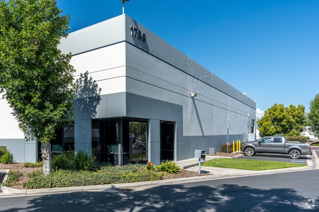
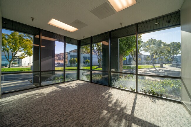
Property Record
1799 Rustin Ave, Riverside, CA 92507

Property Detail
1799 Rustin Ave
249-130-047
1.79 ACRES IN PAR 2 PM 185/033 PM 24553
Lightindustrial
Riverside
MP
California
B and X Area of moderate flood hazard, usually the area between the limits of the 100-year and 500-year floods.
2
2024
1.79 AC
2025
Riverside
042210
Inland Empire (California)
30,502 SF
Riverside-San Bernardino-Ontario, CA
NEARBY LISTINGS FOR SALE OR LEASE
DEMOGRAPHICS near 1799 Rustin Ave
1 mile
3 mile
5 mile
2025 Total Population
10,937
93,194
201,853
2030 Population
11,166
95,678
206,455
Pop Growth 2025-2030
+ 2.09%
+ 2.67%
+ 2.28%
Average Age
31
34
36
2025 Total Households
3,859
28,242
62,689
HH Growth 2025-2030
+ 1.68%
+ 2.28%
+ 1.97%
Median Household Inc
$63,034
$78,934
$86,652
Avg Household Size
2.60
2.90
3.00
2025 Avg HH Vehicles
2.00
2.00
2.00
Median Home Value
$415,027
$574,433
$610,659
Median Year Built
1981
1976
1977
Nearby Places
Map Layers
Map Styles
 Street
 Aerial
Transit
 Traffic
 Biking
Places
Listings with unknown addresses are not visible on the map
- Restaurants
- Banks
- Shops
- Fitness
- Groceries
PUBLIC TRANSPORTATION
COMMUTER RAIL
Riverside-Hunter Park/Ucr (Metrolink 91-Perris Valley Line - Metrolink Trains)
Drive
Walk
Distance
Riverside-Hunter Park/Ucr (Metrolink 91-Perris Valley Line - Metrolink Trains)
0 min
2 min
0.1 mi
Riverside-Downtown (91 Line - Southern California Regional Rail Authority (Metrolink), Inland Empire-Orange County Line - Southern California Regional Rail Authority (Metrolink), Riverside Line - Southern California Regional Rail Authority (Metrolink))
Drive
Walk
Distance
Riverside-Downtown (91 Line - Southern California Regional Rail Authority (Metrolink), Inland Empire-Orange County Line - Southern California Regional Rail Authority (Metrolink), Riverside Line - Southern California Regional Rail Authority (Metrolink))
8 min
3.5 mi
AIRPORT
Ontario International
Drive
Walk
Distance
Ontario International
26 min
19.6 mi
Freight Ports
Port of Long Beach
Drive
Walk
Distance
Port of Long Beach
76 min
59.3 mi
SALE & LEASE HISTORY
LISTING DATE
SALE/LEASE

Feb 16, 2018
For Lease
Feb 13, 2024
For Lease
Nearby Properties
Address
Land Use
TOTAL SIZE
Lot Size
Zoning
Address
Land Use
TOTAL SIZE
Lot Size
Zoning
798,304 SF
42.64 AC
AMSP
Address
Land Use
TOTAL SIZE
Lot Size
Zoning
1,009,120 SF
35.22 AC
Address
Land Use
TOTAL SIZE
Lot Size
Zoning
494,575 SF
25.33 AC
MP
Address
Land Use
TOTAL SIZE
Lot Size
Zoning
599,735 SF
33.25 AC
AMSP
Address
Land Use
TOTAL SIZE
Lot Size
Zoning
369,842 SF
16.35 AC
Address
Land Use
TOTAL SIZE
Lot Size
Zoning
411,707 SF
19.34 AC
Address
Land Use
TOTAL SIZE
Lot Size
Zoning
350,278 SF
1.21 AC
Address
Land Use
TOTAL SIZE
Lot Size
Zoning
126,036 SF
30.90 AC
Address
Land Use
TOTAL SIZE
Lot Size
Zoning
447,190 SF
21.08 AC
Address
Land Use
TOTAL SIZE
Lot Size
Zoning
26,879 SF
16.27 AC
R3
Address
Land Use
TOTAL SIZE
Lot Size
Zoning
217,036 SF
1.66 AC
C2
Address
Land Use
TOTAL SIZE
Lot Size
Zoning
156,241 SF
2.55 AC
Address
Land Use
TOTAL SIZE
Lot Size
Zoning
55.22 AC
AMSP
Address
Land Use
TOTAL SIZE
Lot Size
Zoning
209,734 SF
10.87 AC
R3
Address
Land Use
TOTAL SIZE
Lot Size
Zoning
139,454 SF
0.97 AC
DSP
Address
Land Use
TOTAL SIZE
Lot Size
Zoning
36,010 SF
11.76 AC
R3
Address
Land Use
TOTAL SIZE
Lot Size
Zoning
87,600 SF
0.39 AC
Address
Land Use
TOTAL SIZE
Lot Size
Zoning
182,446 SF
9.01 AC
Address
Land Use
TOTAL SIZE
Lot Size
Zoning
244,495 SF
17.53 AC
MH
Address
Land Use
TOTAL SIZE
Lot Size
Zoning
134,944 SF
2.52 AC
Address
Land Use
TOTAL SIZE
Lot Size
Zoning
415,990 SF
5.16 AC
Address
Land Use
TOTAL SIZE
Lot Size
Zoning
307,163 SF
16.65 AC
Address
Land Use
TOTAL SIZE
Lot Size
Zoning
230,063 SF
11.06 AC
Address
Land Use
TOTAL SIZE
Lot Size
Zoning
85,616 SF
18.64 AC
Address
Land Use
TOTAL SIZE
Lot Size
Zoning
26.48 AC
R3
Address
Land Use
TOTAL SIZE
Lot Size
Zoning
272,472 SF
24.49 AC
N2
The World's #1 Commercial Real Estate Marketplace
Connect with us
© 2026 CoStar Group
The information above has been obtained from sources believed reliable. While we do not doubt its accuracy we have not verified it and make no guarantee, warranty or representation about it. It is your responsibility to independently confirm its accuracy and completeness. Any projections, opinions, assumptions, or estimates used are for example only and do not represent the current or future performance of the property. The value of this transaction to you depends on tax and other factors which should be evaluated by your tax, financial, and legal advisors. You and your advisors should conduct a careful, independent investigation of the property to determine to your satisfaction the suitability of the property for your needs.