Property Record
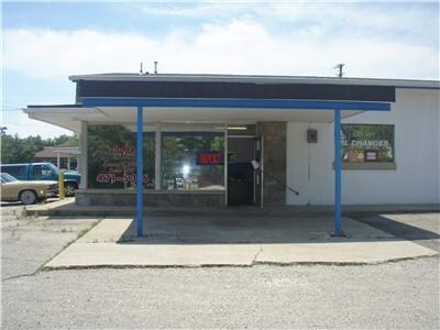
180 W Johnstown Rd, Columbus, OH 43230

NEARBY LISTINGS FOR SALE OR LEASE
Property Detail
180 W Johnstown Rd
025-000820
Us Military Lands
Servicestation
180 JOHNSTOWN RD R17 T1 1/4T4 0.5428 ACRE
X
Franklin
39049C0194K
Ohio
2024
0.54 AC
2024
East
007425
Columbus
4,244 SF
Columbus, OH
DEMOGRAPHICS near 180 W Johnstown Rd
1 Mile
3 Mile
5 Mile
2024 Total Population
9,014
59,422
239,183
2029 Population
9,008
59,395
239,675
Pop Growth 2024-2029
(0.07%)
(0.05%)
+ 0.21%
Average Age
41
38
38
2024 Total Households
3,743
23,829
95,128
HH Growth 2024-2029
(0.05%)
(0.08%)
+ 0.18%
Median Household Inc
$79,034
$74,418
$59,998
Avg Household Size
2.30
2.40
2.40
2024 Avg HH Vehicles
2.00
2.00
2.00
Median Home Value
$216,449
$257,868
$232,036
Median Year Built
1968
1987
1978
Nearby Places
Map Layers
Map Styles
 Street
 Aerial
- Restaurants
- Banks
- Shops
- Fitness
- Groceries
PUBLIC TRANSPORTATION
AIRPORT
John Glenn Columbus International
DRIVE
WALK
Distance
John Glenn Columbus International
7 min
3.4 mi
Rickenbacker International
DRIVE
WALK
Distance
Rickenbacker International
25 min
18.0 mi
Freight Ports
Port of Toledo
DRIVE
WALK
Distance
Port of Toledo
182 min
145.4 mi
Nearby Properties
Address
Land Use
TOTAL SIZE
Lot Size
Zoning
Address
Land Use
TOTAL SIZE
Lot Size
Zoning
316,415 SF
415.78 AC
Address
Land Use
TOTAL SIZE
Lot Size
Zoning
1,256,678 SF
1,292.62 AC
Address
Land Use
TOTAL SIZE
Lot Size
Zoning
2,299,970 SF
60.76 AC
Address
Land Use
TOTAL SIZE
Lot Size
Zoning
Address
Land Use
TOTAL SIZE
Lot Size
Zoning
1,935,173 SF
202.04 AC
Address
Land Use
TOTAL SIZE
Lot Size
Zoning
529,035 SF
37.56 AC
Address
Land Use
TOTAL SIZE
Lot Size
Zoning
449,494 SF
9.75 AC
Address
Land Use
TOTAL SIZE
Lot Size
Zoning
570,003 SF
29.71 AC
Address
Land Use
TOTAL SIZE
Lot Size
Zoning
770,975 SF
64.63 AC
Address
Land Use
TOTAL SIZE
Lot Size
Zoning
316,548 SF
145.20 AC
Address
Land Use
TOTAL SIZE
Lot Size
Zoning
25,298 SF
33.25 AC
Address
Land Use
TOTAL SIZE
Lot Size
Zoning
329,049 SF
38.53 AC
Address
Land Use
TOTAL SIZE
Lot Size
Zoning
242,064 SF
18.02 AC
Address
Land Use
TOTAL SIZE
Lot Size
Zoning
240,432 SF
16.59 AC
Address
Land Use
TOTAL SIZE
Lot Size
Zoning
122,526 SF
27 AC
Address
Land Use
TOTAL SIZE
Lot Size
Zoning
150,424 SF
26.82 AC
Address
Land Use
TOTAL SIZE
Lot Size
Zoning
537,537 SF
77.62 AC
Address
Land Use
TOTAL SIZE
Lot Size
Zoning
47,003 SF
24.68 AC
Address
Land Use
TOTAL SIZE
Lot Size
Zoning
214,424 SF
18.57 AC
Address
Land Use
TOTAL SIZE
Lot Size
Zoning
299,890 SF
74.80 AC
Address
Land Use
TOTAL SIZE
Lot Size
Zoning
282,035 SF
29.29 AC
Address
Land Use
TOTAL SIZE
Lot Size
Zoning
88,068 SF
15.43 AC
Address
Land Use
TOTAL SIZE
Lot Size
Zoning
668,209 SF
61.10 AC
Address
Land Use
TOTAL SIZE
Lot Size
Zoning
274,272 SF
6.45 AC
Address
Land Use
TOTAL SIZE
Lot Size
Zoning
331,458 SF
15.37 AC
Address
Land Use
TOTAL SIZE
Lot Size
Zoning
42,596 SF
37.05 AC
Address
Land Use
TOTAL SIZE
Lot Size
Zoning
67,166 SF
11.03 AC
Address
Land Use
TOTAL SIZE
Lot Size
Zoning
500,376 SF
3 AC
Address
Land Use
TOTAL SIZE
Lot Size
Zoning
166,628 SF
9.98 AC
Address
Land Use
TOTAL SIZE
Lot Size
Zoning
202,956 SF
13.40 AC
The World's #1 Commercial Real Estate Marketplace
Connect with us
© 2025 CoStar Group
The information above has been obtained from sources believed reliable. While we do not doubt its accuracy we have not verified it and make no guarantee, warranty or representation about it. It is your responsibility to independently confirm its accuracy and completeness. Any projections, opinions, assumptions, or estimates used are for example only and do not represent the current or future performance of the property. The value of this transaction to you depends on tax and other factors which should be evaluated by your tax, financial, and legal advisors. You and your advisors should conduct a careful, independent investigation of the property to determine to your satisfaction the suitability of the property for your needs.