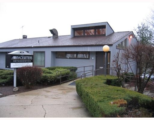
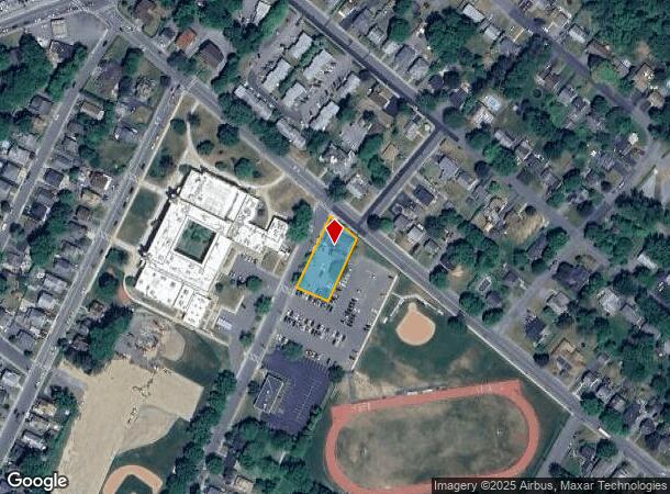
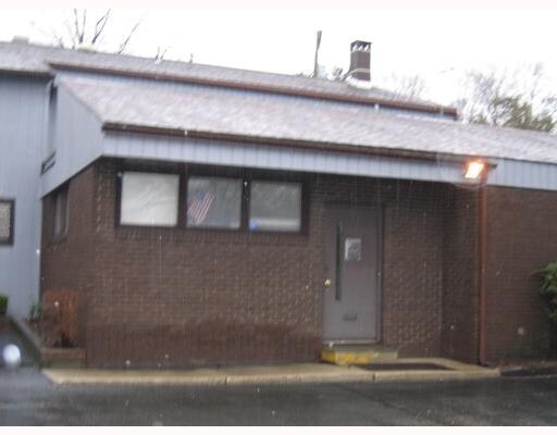
Property Record
180 Wisner Ave, Middletown, NY 10940
NEARBY LISTINGS FOR SALE OR LEASE
Property Detail
180 Wisner Ave
330900-027-000-0009-001.000-0000
Orange
Commercialbuilding
New York
X
1.000
36071C0259E
0.47 AC
2024
Middletown
2024
Northern New Jersey
001100
New York-Jersey City-White Plains, NY-NJ
46 SF
DEMOGRAPHICS near 180 Wisner Ave
1 Mile
3 Mile
5 Mile
2024 Total Population
16,329
53,059
68,001
2029 Population
16,550
54,054
69,241
Pop Growth 2024-2029
+ 1.35%
+ 1.88%
+ 1.82%
Average Age
38
39
40
2024 Total Households
5,976
19,707
24,829
HH Growth 2024-2029
+ 1.47%
+ 2.04%
+ 1.99%
Median Household Inc
$63,005
$74,801
$79,526
Avg Household Size
2.60
2.60
2.60
2024 Avg HH Vehicles
2.00
2.00
2.00
Median Home Value
$226,534
$252,356
$275,452
Median Year Built
1962
1974
1974
Nearby Places
- Restaurants
- Banks
- Shops
- Fitness
- Groceries
PUBLIC TRANSPORTATION
COMMUTER RAIL
Middletown New York (Bergen County/Port Jervis Line - NJ Transit Commuter Rail (NJ Transit), Main/Port Jervis Line - NJ Transit Commuter Rail (NJ Transit))
DRIVE
WALK
Distance
Middletown New York (Bergen County/Port Jervis Line - NJ Transit Commuter Rail (NJ Transit), Main/Port Jervis Line - NJ Transit Commuter Rail (NJ Transit))
8 min
2.6 mi
Otisville (Bergen County/Port Jervis Line - NJ Transit Commuter Rail (NJ Transit), Main/Port Jervis Line - NJ Transit Commuter Rail (NJ Transit))
DRIVE
WALK
Distance
Otisville (Bergen County/Port Jervis Line - NJ Transit Commuter Rail (NJ Transit), Main/Port Jervis Line - NJ Transit Commuter Rail (NJ Transit))
13 min
8.3 mi
AIRPORT
New York Stewart International
DRIVE
WALK
Distance
New York Stewart International
30 min
20.3 mi
Nearby Properties
Address
Land Use
TOTAL SIZE
Lot Size
Zoning
Address
Land Use
TOTAL SIZE
Lot Size
Zoning
275,216 SF
58.40 AC
O/R
Address
Land Use
TOTAL SIZE
Lot Size
Zoning
Address
Land Use
TOTAL SIZE
Lot Size
Zoning
40.40 AC
I-2
Address
Land Use
TOTAL SIZE
Lot Size
Zoning
698,289 SF
52.20 AC
Address
Land Use
TOTAL SIZE
Lot Size
Zoning
180,840 SF
37.50 AC
TC
Address
Land Use
TOTAL SIZE
Lot Size
Zoning
24.40 AC
R-1
Address
Land Use
TOTAL SIZE
Lot Size
Zoning
376,002 SF
34.40 AC
TC
Address
Land Use
TOTAL SIZE
Lot Size
Zoning
29,950 SF
3 AC
TC-1
Address
Land Use
TOTAL SIZE
Lot Size
Zoning
26,659 SF
15.80 AC
MC 2
Address
Land Use
TOTAL SIZE
Lot Size
Zoning
17.60 AC
R-1
Address
Land Use
TOTAL SIZE
Lot Size
Zoning
Address
Land Use
TOTAL SIZE
Lot Size
Zoning
14.70 AC
MC 1
Address
Land Use
TOTAL SIZE
Lot Size
Zoning
637,520 SF
44.70 AC
ENT-L
Address
Land Use
TOTAL SIZE
Lot Size
Zoning
50,700 SF
7.70 AC
TC-1
Address
Land Use
TOTAL SIZE
Lot Size
Zoning
142,416 SF
13.90 AC
R1
Address
Land Use
TOTAL SIZE
Lot Size
Zoning
289,910 SF
19.90 AC
TC
Address
Land Use
TOTAL SIZE
Lot Size
Zoning
26,156 SF
0.01 AC
TC-1
Address
Land Use
TOTAL SIZE
Lot Size
Zoning
1,360 SF
6.30 AC
Address
Land Use
TOTAL SIZE
Lot Size
Zoning
5,832 SF
2.30 AC
TC-1
Address
Land Use
TOTAL SIZE
Lot Size
Zoning
270,471 SF
78.40 AC
R1
Address
Land Use
TOTAL SIZE
Lot Size
Zoning
136,784 SF
6 AC
O/R
Address
Land Use
TOTAL SIZE
Lot Size
Zoning
5,753 SF
18 AC
TC
Address
Land Use
TOTAL SIZE
Lot Size
Zoning
125,616 SF
11.50 AC
O/R
Address
Land Use
TOTAL SIZE
Lot Size
Zoning
208,464 SF
24.90 AC
HC
Address
Land Use
TOTAL SIZE
Lot Size
Zoning
141,454 SF
12 AC
TC
Address
Land Use
TOTAL SIZE
Lot Size
Zoning
7 AC
C-3
Address
Land Use
TOTAL SIZE
Lot Size
Zoning
6.80 AC
MC 1
Address
Land Use
TOTAL SIZE
Lot Size
Zoning
83,832 SF
4.20 AC
TC
Address
Land Use
TOTAL SIZE
Lot Size
Zoning
96,231 SF
14.80 AC
HC
Address
Land Use
TOTAL SIZE
Lot Size
Zoning
41,728 SF
5 AC
TC-1
The World's #1 Commercial Real Estate Marketplace
Connect with us
© 2025 CoStar Group
The information above has been obtained from sources believed reliable. While we do not doubt its accuracy we have not verified it and make no guarantee, warranty or representation about it. It is your responsibility to independently confirm its accuracy and completeness. Any projections, opinions, assumptions, or estimates used are for example only and do not represent the current or future performance of the property. The value of this transaction to you depends on tax and other factors which should be evaluated by your tax, financial, and legal advisors. You and your advisors should conduct a careful, independent investigation of the property to determine to your satisfaction the suitability of the property for your needs.