Property Record
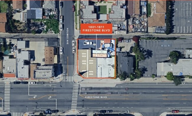
1801 Firestone Blvd, Los Angeles, CA 90001
This Property Is For Sale
NEARBY LISTINGS FOR SALE OR LEASE
Property Detail
1801 Firestone Blvd
Los Angeles-Long Beach-Glendale, CA
Edgewood Park
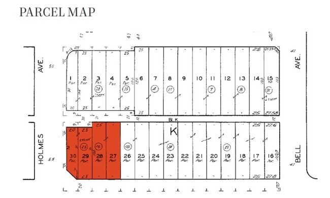
6027-032-025
*TR=EDGEWOOD PARK*(EX OF ST AND ALLEY) LOT 29 AND (EX OF STS AND ALLEY) LOT 30 BLK K
Warehouse
Los Angeles
X
California
06037C1805F
29,30
2024
0.09 AC
2025
South LA
535002
Los Angeles
2,756 SF
DEMOGRAPHICS near 1801 Firestone Blvd
1 Mile
3 Mile
5 Mile
2024 Total Population
51,708
439,822
988,770
2029 Population
50,434
429,272
968,856
Pop Growth 2024-2029
(2.46%)
(2.40%)
(2.01%)
Average Age
35
35
36
2024 Total Households
12,054
109,034
254,154
HH Growth 2024-2029
(2.80%)
(2.77%)
(2.31%)
Median Household Inc
$64,861
$59,942
$62,483
Avg Household Size
4.10
3.80
3.70
2024 Avg HH Vehicles
2.00
2.00
2.00
Median Home Value
$619,464
$651,582
$672,214
Median Year Built
1949
1953
1952
Nearby Places
- Restaurants
- Banks
- Shops
- Fitness
- Groceries
PUBLIC TRANSPORTATION
COMMUTER RAIL
DRIVE
WALK
Distance
16 min
7.2 mi
Union Station (91 Line - Southern California Regional Rail Authority (Metrolink), Antelope Valley Line - Southern California Regional Rail Authority (Metrolink), Orange County Line - Southern California Regional Rail Authority (Metrolink), Riverside Line - Southern California Regional Rail Authority (Metrolink), San Bernardino Line - Southern California Regional Rail Authority (Metrolink), Ventura County Line - Southern California Regional Rail Authority (Metrolink))
DRIVE
WALK
Distance
Union Station (91 Line - Southern California Regional Rail Authority (Metrolink), Antelope Valley Line - Southern California Regional Rail Authority (Metrolink), Orange County Line - Southern California Regional Rail Authority (Metrolink), Riverside Line - Southern California Regional Rail Authority (Metrolink), San Bernardino Line - Southern California Regional Rail Authority (Metrolink), Ventura County Line - Southern California Regional Rail Authority (Metrolink))
18 min
7.6 mi
AIRPORT
Los Angeles International
DRIVE
WALK
Distance
Los Angeles International
21 min
13.4 mi
Long Beach (Daugherty Field)
DRIVE
WALK
Distance
Long Beach (Daugherty Field)
24 min
15.1 mi
Bob Hope
DRIVE
WALK
Distance
Bob Hope
37 min
24.2 mi
Freight Ports
Port of Long Beach
DRIVE
WALK
Distance
Port of Long Beach
27 min
17.0 mi
Nearby Properties
Address
Land Use
TOTAL SIZE
Lot Size
Zoning
Address
Land Use
TOTAL SIZE
Lot Size
Zoning
227,179 SF
10.46 AC
VEM*
Address
Land Use
TOTAL SIZE
Lot Size
Zoning
323,368 SF
15.18 AC
LYM*
Address
Land Use
TOTAL SIZE
Lot Size
Zoning
326,472 SF
14.53 AC
VEM*
Address
Land Use
TOTAL SIZE
Lot Size
Zoning
108,598 SF
15.93 AC
LCC3*
Address
Land Use
TOTAL SIZE
Lot Size
Zoning
248,925 SF
10.91 AC
LYCB1*
Address
Land Use
TOTAL SIZE
Lot Size
Zoning
Address
Land Use
TOTAL SIZE
Lot Size
Zoning
279,682 SF
6.98 AC
VEM*
Address
Land Use
TOTAL SIZE
Lot Size
Zoning
37,867 SF
8.32 AC
COMH-B*
Address
Land Use
TOTAL SIZE
Lot Size
Zoning
116,728 SF
0.86 AC
HPCP*
Address
Land Use
TOTAL SIZE
Lot Size
Zoning
63,922 SF
1.82 AC
LCA16000*
Address
Land Use
TOTAL SIZE
Lot Size
Zoning
200,043 SF
8.68 AC
LYM*
Address
Land Use
TOTAL SIZE
Lot Size
Zoning
369,554 SF
8.49 AC
VEM*
Address
Land Use
TOTAL SIZE
Lot Size
Zoning
261,540 SF
10.85 AC
VEM*
Address
Land Use
TOTAL SIZE
Lot Size
Zoning
108,641 SF
5.34 AC
VEM*
Address
Land Use
TOTAL SIZE
Lot Size
Zoning
289,913 SF
8.25 AC
VEM*
Address
Land Use
TOTAL SIZE
Lot Size
Zoning
99,065 SF
4.51 AC
VEM*
Address
Land Use
TOTAL SIZE
Lot Size
Zoning
183,319 SF
9.77 AC
VEM*
Address
Land Use
TOTAL SIZE
Lot Size
Zoning
2.65 AC
HPM2
Address
Land Use
TOTAL SIZE
Lot Size
Zoning
498,163 SF
11.53 AC
LYM*
Address
Land Use
TOTAL SIZE
Lot Size
Zoning
196,676 SF
9.80 AC
SGM3
Address
Land Use
TOTAL SIZE
Lot Size
Zoning
127,484 SF
7.33 AC
LAM2
Address
Land Use
TOTAL SIZE
Lot Size
Zoning
165,235 SF
1.13 AC
LAM2
Address
Land Use
TOTAL SIZE
Lot Size
Zoning
811,955 SF
18.57 AC
VEM*
Address
Land Use
TOTAL SIZE
Lot Size
Zoning
197,131 SF
9.16 AC
VEM*
Address
Land Use
TOTAL SIZE
Lot Size
Zoning
320,526 SF
7.92 AC
VEM*
Address
Land Use
TOTAL SIZE
Lot Size
Zoning
104,291 SF
7.35 AC
LAR3
Address
Land Use
TOTAL SIZE
Lot Size
Zoning
262,928 SF
VEM*
Address
Land Use
TOTAL SIZE
Lot Size
Zoning
134,514 SF
1.94 AC
LCM2*
Address
Land Use
TOTAL SIZE
Lot Size
Zoning
262,928 SF
4.07 AC
VEM*
Address
Land Use
TOTAL SIZE
Lot Size
Zoning
282,847 SF
4.23 AC
VEM*
The World's #1 Commercial Real Estate Marketplace
Connect with us
© 2025 CoStar Group
The information above has been obtained from sources believed reliable. While we do not doubt its accuracy we have not verified it and make no guarantee, warranty or representation about it. It is your responsibility to independently confirm its accuracy and completeness. Any projections, opinions, assumptions, or estimates used are for example only and do not represent the current or future performance of the property. The value of this transaction to you depends on tax and other factors which should be evaluated by your tax, financial, and legal advisors. You and your advisors should conduct a careful, independent investigation of the property to determine to your satisfaction the suitability of the property for your needs.