Property Record
1801 Gerhart Dr, Clinton, MO 64735

Save to a Folder
{{folder.Name}}
{{folder.ListingIds.length}} Properties
{{folder.ListingIds.length}} Property
Create a New Folder
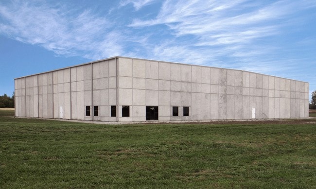
Property Detail
1801 Gerhart Dr
13-8.0-34-002-001-002.002
GERHART INDUSTRIAL PARK-LT 15 & GERHART INDUSTRIAL PARK, REPLAT LTS 11 & 13-S 450' LT 13 (100% ABATED FOR BEING IN ENTERPRISE
Commercialnec
HENRY
B and X Area of moderate flood hazard, usually the area between the limits of the 100-year and 500-year floods.
Missouri
2025
13,15
2025
10.90 AC
950500
Missouri South Central Area
61,800 SF
Other Market Areas
NEARBY LISTINGS FOR SALE OR LEASE
-
-
View all Clinton listings for lease on LoopNet.com
DEMOGRAPHICS near 1801 Gerhart Dr
1 mile
3 mile
5 mile
2025 Total Population
487
8,854
10,194
2030 Population
489
8,872
10,221
Pop Growth 2025-2030
+ 0.41%
+ 0.20%
+ 0.26%
Average Age
42
42
43
2025 Total Households
202
3,832
4,411
HH Growth 2025-2030
+ 0.50%
+ 0.21%
+ 0.29%
Median Household Inc
$43,749
$50,052
$53,098
Avg Household Size
2.30
2.20
2.20
2025 Avg HH Vehicles
2.00
2.00
2.00
Median Home Value
$182,142
$165,565
$175,596
Median Year Built
1978
1970
1971
Nearby Places
Map Layers
Map Styles
 Street
 Aerial
Layers
 Traffic
 Biking
Places
Listings with unknown addresses are not visible on the map
- Restaurants
- Banks
- Shops
- Fitness
- Groceries
SALE & LEASE HISTORY
LISTING DATE
SALE/LEASE

Sep 25, 2016
For Lease
Sep 23, 2016
For Sale
Nearby Properties
Address
Land Use
TOTAL SIZE
Lot Size
Zoning
Address
Land Use
TOTAL SIZE
Lot Size
Zoning
Address
Land Use
TOTAL SIZE
Lot Size
Zoning
1,170 SF
37.40 AC
Address
Land Use
TOTAL SIZE
Lot Size
Zoning
10,000 SF
3.60 AC
Address
Land Use
TOTAL SIZE
Lot Size
Zoning
8,020 SF
20.20 AC
Address
Land Use
TOTAL SIZE
Lot Size
Zoning
1,500 SF
28.80 AC
Address
Land Use
TOTAL SIZE
Lot Size
Zoning
27,354 SF
4.60 AC
Address
Land Use
TOTAL SIZE
Lot Size
Zoning
9,169 SF
3 AC
AP
Address
Land Use
TOTAL SIZE
Lot Size
Zoning
21,830 SF
3.38 AC
Address
Land Use
TOTAL SIZE
Lot Size
Zoning
22,000 SF
19.80 AC
Address
Land Use
TOTAL SIZE
Lot Size
Zoning
61,075 SF
8.20 AC
Address
Land Use
TOTAL SIZE
Lot Size
Zoning
14,842 SF
3.26 AC
Address
Land Use
TOTAL SIZE
Lot Size
Zoning
4,499 SF
2.90 AC
AP
Address
Land Use
TOTAL SIZE
Lot Size
Zoning
44.10 AC
Address
Land Use
TOTAL SIZE
Lot Size
Zoning
15,846 SF
3 AC
RC
Address
Land Use
TOTAL SIZE
Lot Size
Zoning
12,092 SF
0.59 AC
Address
Land Use
TOTAL SIZE
Lot Size
Zoning
53,323 SF
5.90 AC
AP
Address
Land Use
TOTAL SIZE
Lot Size
Zoning
12,000 SF
2.20 AC
Address
Land Use
TOTAL SIZE
Lot Size
Zoning
13,108 SF
1.90 AC
Address
Land Use
TOTAL SIZE
Lot Size
Zoning
7,235 SF
2.40 AC
AI
Address
Land Use
TOTAL SIZE
Lot Size
Zoning
5.30 AC
NC
Address
Land Use
TOTAL SIZE
Lot Size
Zoning
15,202 SF
1.90 AC
Address
Land Use
TOTAL SIZE
Lot Size
Zoning
4,857 SF
1.90 AC
AI
Address
Land Use
TOTAL SIZE
Lot Size
Zoning
31,550 SF
2 AC
Address
Land Use
TOTAL SIZE
Lot Size
Zoning
2,916 SF
0.57 AC
Address
Land Use
TOTAL SIZE
Lot Size
Zoning
21,592 SF
3.90 AC
NC
Address
Land Use
TOTAL SIZE
Lot Size
Zoning
2,880 SF
0.29 AC
Address
Land Use
TOTAL SIZE
Lot Size
Zoning
5,170 SF
0.79 AC
Address
Land Use
TOTAL SIZE
Lot Size
Zoning
16,912 SF
5.60 AC
Address
Land Use
TOTAL SIZE
Lot Size
Zoning
8,095 SF
0.20 AC
The World's #1 Commercial Real Estate Marketplace
Connect with us
© 2026 CoStar Group
The information above has been obtained from sources believed reliable. While we do not doubt its accuracy we have not verified it and make no guarantee, warranty or representation about it. It is your responsibility to independently confirm its accuracy and completeness. Any projections, opinions, assumptions, or estimates used are for example only and do not represent the current or future performance of the property. The value of this transaction to you depends on tax and other factors which should be evaluated by your tax, financial, and legal advisors. You and your advisors should conduct a careful, independent investigation of the property to determine to your satisfaction the suitability of the property for your needs.