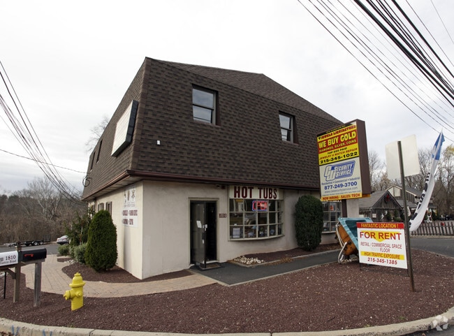
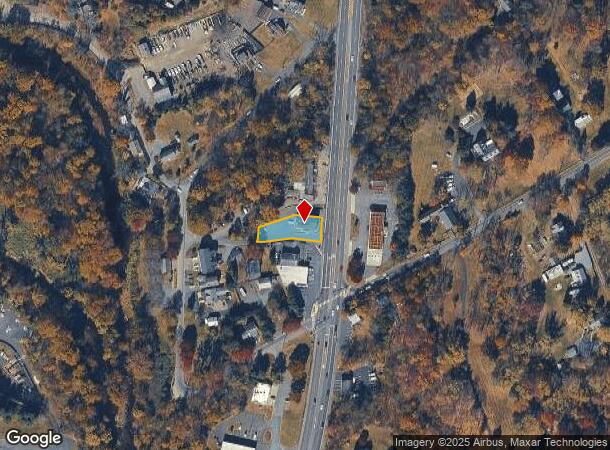
Property Record
1810 S Easton Rd, Doylestown, PA 18901
NEARBY LISTINGS FOR SALE OR LEASE
Property Detail
1810 S Easton Rd
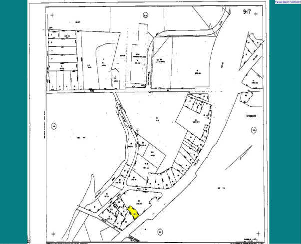
09-017-035-001
0.47AC W S US611 250 FT N LR09067
Officebuilding
Bucks
X
Pennsylvania
42017C0292K
0.47 AC
2024
Upper Bucks County
2025
Philadelphia
104603
Philadelphia-Camden-Wilmington, PA-NJ-DE-MD
4,456 SF
DEMOGRAPHICS near 1810 S Easton Rd
1 Mile
3 Mile
5 Mile
2024 Total Population
3,867
51,167
112,991
2029 Population
3,874
51,401
113,057
Pop Growth 2024-2029
+ 0.18%
+ 0.46%
+ 0.06%
Average Age
47
43
43
2024 Total Households
1,089
18,719
41,659
HH Growth 2024-2029
+ 0.18%
+ 0.64%
+ 0.13%
Median Household Inc
$130,882
$125,959
$124,038
Avg Household Size
2.40
2.60
2.60
2024 Avg HH Vehicles
2.00
2.00
2.00
Median Home Value
$622,381
$533,483
$472,293
Median Year Built
1981
1983
1985
Nearby Places
Map Layers
Map Styles
 Street
 Aerial
- Restaurants
- Banks
- Shops
- Fitness
- Groceries
PUBLIC TRANSPORTATION
COMMUTER RAIL
Doylestown (R5 - Southeastern Pennsylvania Transportation Authority Regional Rail (SEPTA Regional Rail))
DRIVE
WALK
Distance
Doylestown (R5 - Southeastern Pennsylvania Transportation Authority Regional Rail (SEPTA Regional Rail))
4 min
1.9 mi
Delaware Valley College (R5 - Southeastern Pennsylvania Transportation Authority Regional Rail (SEPTA Regional Rail))
DRIVE
WALK
Distance
Delaware Valley College (R5 - Southeastern Pennsylvania Transportation Authority Regional Rail (SEPTA Regional Rail))
6 min
3.2 mi
AIRPORT
Trenton Mercer
DRIVE
WALK
Distance
Trenton Mercer
38 min
22.5 mi
Philadelphia International
DRIVE
WALK
Distance
Philadelphia International
65 min
44.3 mi
Freight Ports
Port of Philadelphia
DRIVE
WALK
Distance
Port of Philadelphia
44 min
23.3 mi
SALE & LEASE HISTORY
LISTING DATE
SALE/LEASE

Dec 21, 2020
For Lease
Nearby Properties
Address
Land Use
TOTAL SIZE
Lot Size
Zoning
Address
Land Use
TOTAL SIZE
Lot Size
Zoning
254,699 SF
22.06 AC
RC
Address
Land Use
TOTAL SIZE
Lot Size
Zoning
8,120 SF
56.80 AC
C3
Address
Land Use
TOTAL SIZE
Lot Size
Zoning
30,939 SF
28.69 AC
I
Address
Land Use
TOTAL SIZE
Lot Size
Zoning
254,330 SF
25.38 AC
C2
Address
Land Use
TOTAL SIZE
Lot Size
Zoning
344,604 SF
6.95 AC
LI
Address
Land Use
TOTAL SIZE
Lot Size
Zoning
146,924 SF
17.47 AC
C2
Address
Land Use
TOTAL SIZE
Lot Size
Zoning
90,000 SF
7.25 AC
R2
Address
Land Use
TOTAL SIZE
Lot Size
Zoning
77,630 SF
28.53 AC
R2B
Address
Land Use
TOTAL SIZE
Lot Size
Zoning
91,222 SF
13.75 AC
R2
Address
Land Use
TOTAL SIZE
Lot Size
Zoning
97,496 SF
12.67 AC
R3
Address
Land Use
TOTAL SIZE
Lot Size
Zoning
230,150 SF
12.10 AC
CR-H
Address
Land Use
TOTAL SIZE
Lot Size
Zoning
89,417 SF
13.30 AC
CR
Address
Land Use
TOTAL SIZE
Lot Size
Zoning
77,964 SF
9.79 AC
R3
Address
Land Use
TOTAL SIZE
Lot Size
Zoning
54,090 SF
7.25 AC
R4
Address
Land Use
TOTAL SIZE
Lot Size
Zoning
25,188 SF
8.51 AC
R2
Address
Land Use
TOTAL SIZE
Lot Size
Zoning
5,588 SF
0.82 AC
FC
Address
Land Use
TOTAL SIZE
Lot Size
Zoning
153,564 SF
13.12 AC
R2
Address
Land Use
TOTAL SIZE
Lot Size
Zoning
16,828 SF
3.28 AC
R2
Address
Land Use
TOTAL SIZE
Lot Size
Zoning
63,612 SF
0.47 AC
CI
Address
Land Use
TOTAL SIZE
Lot Size
Zoning
38,320 SF
11.91 AC
AG
Address
Land Use
TOTAL SIZE
Lot Size
Zoning
92,454 SF
12.48 AC
R1
Address
Land Use
TOTAL SIZE
Lot Size
Zoning
33,658 SF
0.52 AC
Address
Land Use
TOTAL SIZE
Lot Size
Zoning
51,286 SF
12.56 AC
R1
Address
Land Use
TOTAL SIZE
Lot Size
Zoning
63,612 SF
0.50 AC
CI
Address
Land Use
TOTAL SIZE
Lot Size
Zoning
61,558 SF
7.48 AC
C2
Address
Land Use
TOTAL SIZE
Lot Size
Zoning
26,134 SF
8.37 AC
C2
Address
Land Use
TOTAL SIZE
Lot Size
Zoning
31,122 SF
9.86 AC
C2
Address
Land Use
TOTAL SIZE
Lot Size
Zoning
42,587 SF
12.09 AC
R1
Address
Land Use
TOTAL SIZE
Lot Size
Zoning
24,300 SF
3.36 AC
C1
Address
Land Use
TOTAL SIZE
Lot Size
Zoning
21,285 SF
118.88 AC
R1
The World's #1 Commercial Real Estate Marketplace
Connect with us
© 2025 CoStar Group
The information above has been obtained from sources believed reliable. While we do not doubt its accuracy we have not verified it and make no guarantee, warranty or representation about it. It is your responsibility to independently confirm its accuracy and completeness. Any projections, opinions, assumptions, or estimates used are for example only and do not represent the current or future performance of the property. The value of this transaction to you depends on tax and other factors which should be evaluated by your tax, financial, and legal advisors. You and your advisors should conduct a careful, independent investigation of the property to determine to your satisfaction the suitability of the property for your needs.