Property Record
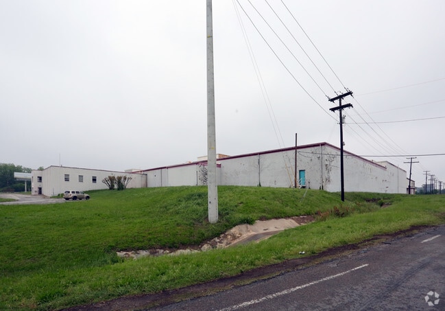
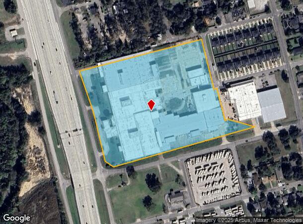
1815 S Sam Rayburn Fwy, Sherman, TX 75090
NEARBY LISTINGS FOR SALE OR LEASE
Property Detail
1815 S Sam Rayburn Fwy
Sherman-Denison, TX
Southside Addn (Replat)
166651
SOUTHSIDE ADDN (REPLAT), LOT PT 9 THRU 11, & PT ELM STREET // 454260 SQ FT, ACRES 12.69
Industrialgeneral
Grayson
X
Texas
48181C0405G
9-11
2024
12.69 AC
2025
Texas East Area
001700
Other Market Areas
334,272 SF
DEMOGRAPHICS near 1815 S Sam Rayburn Fwy
1 Mile
3 Mile
5 Mile
2024 Total Population
4,201
34,703
48,590
2029 Population
4,783
39,377
55,087
Pop Growth 2024-2029
+ 13.85%
+ 13.47%
+ 13.37%
Average Age
35
37
38
2024 Total Households
1,447
12,843
18,633
HH Growth 2024-2029
+ 14.37%
+ 13.98%
+ 13.87%
Median Household Inc
$51,058
$52,033
$55,376
Avg Household Size
2.80
2.50
2.50
2024 Avg HH Vehicles
2.00
2.00
2.00
Median Home Value
$141,008
$171,538
$196,547
Median Year Built
1967
1971
1978
Nearby Places
- Restaurants
- Banks
- Shops
- Fitness
- Groceries
SALE & LEASE HISTORY
LISTING DATE
SALE/LEASE

Sep 30, 2019
For Sale
Sep 27, 2019
For Sale
Oct 14, 2020
For Sale
Nearby Properties
Address
Land Use
TOTAL SIZE
Lot Size
Zoning
Address
Land Use
TOTAL SIZE
Lot Size
Zoning
78,200 SF
208.80 AC
Address
Land Use
TOTAL SIZE
Lot Size
Zoning
527,042 SF
92.91 AC
Address
Land Use
TOTAL SIZE
Lot Size
Zoning
476,941 SF
29.79 AC
Address
Land Use
TOTAL SIZE
Lot Size
Zoning
550,172 SF
73.76 AC
Address
Land Use
TOTAL SIZE
Lot Size
Zoning
208.80 AC
Address
Land Use
TOTAL SIZE
Lot Size
Zoning
227,312 SF
11.72 AC
Address
Land Use
TOTAL SIZE
Lot Size
Zoning
316,728 SF
64.40 AC
Address
Land Use
TOTAL SIZE
Lot Size
Zoning
142,834 SF
9.85 AC
Address
Land Use
TOTAL SIZE
Lot Size
Zoning
214,784 SF
15.05 AC
Address
Land Use
TOTAL SIZE
Lot Size
Zoning
81,100 SF
1.13 AC
Address
Land Use
TOTAL SIZE
Lot Size
Zoning
Address
Land Use
TOTAL SIZE
Lot Size
Zoning
170,359 SF
9.64 AC
Address
Land Use
TOTAL SIZE
Lot Size
Zoning
78,278 SF
8.21 AC
Address
Land Use
TOTAL SIZE
Lot Size
Zoning
136,640 SF
4.04 AC
Address
Land Use
TOTAL SIZE
Lot Size
Zoning
136,262 SF
25.97 AC
Address
Land Use
TOTAL SIZE
Lot Size
Zoning
39,850 SF
5.32 AC
Address
Land Use
TOTAL SIZE
Lot Size
Zoning
297,962 SF
51 AC
Address
Land Use
TOTAL SIZE
Lot Size
Zoning
186,834 SF
10.51 AC
Address
Land Use
TOTAL SIZE
Lot Size
Zoning
136,500 SF
6.42 AC
Address
Land Use
TOTAL SIZE
Lot Size
Zoning
316,318 SF
5.20 AC
Address
Land Use
TOTAL SIZE
Lot Size
Zoning
128,000 SF
11.23 AC
Address
Land Use
TOTAL SIZE
Lot Size
Zoning
208 AC
Address
Land Use
TOTAL SIZE
Lot Size
Zoning
75,522 SF
8.07 AC
Address
Land Use
TOTAL SIZE
Lot Size
Zoning
160,592 SF
8.92 AC
Address
Land Use
TOTAL SIZE
Lot Size
Zoning
518,268 SF
70 AC
Address
Land Use
TOTAL SIZE
Lot Size
Zoning
127,848 SF
9.60 AC
Address
Land Use
TOTAL SIZE
Lot Size
Zoning
34,135 SF
10 AC
Address
Land Use
TOTAL SIZE
Lot Size
Zoning
121,903 SF
10 AC
Address
Land Use
TOTAL SIZE
Lot Size
Zoning
253,973 SF
43.50 AC
Address
Land Use
TOTAL SIZE
Lot Size
Zoning
156,800 SF
9.79 AC
The World's #1 Commercial Real Estate Marketplace
Connect with us
© 2025 CoStar Group
The information above has been obtained from sources believed reliable. While we do not doubt its accuracy we have not verified it and make no guarantee, warranty or representation about it. It is your responsibility to independently confirm its accuracy and completeness. Any projections, opinions, assumptions, or estimates used are for example only and do not represent the current or future performance of the property. The value of this transaction to you depends on tax and other factors which should be evaluated by your tax, financial, and legal advisors. You and your advisors should conduct a careful, independent investigation of the property to determine to your satisfaction the suitability of the property for your needs.