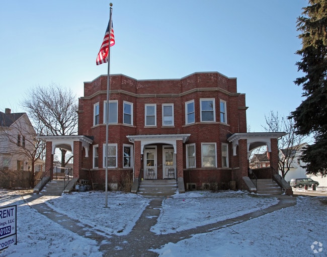
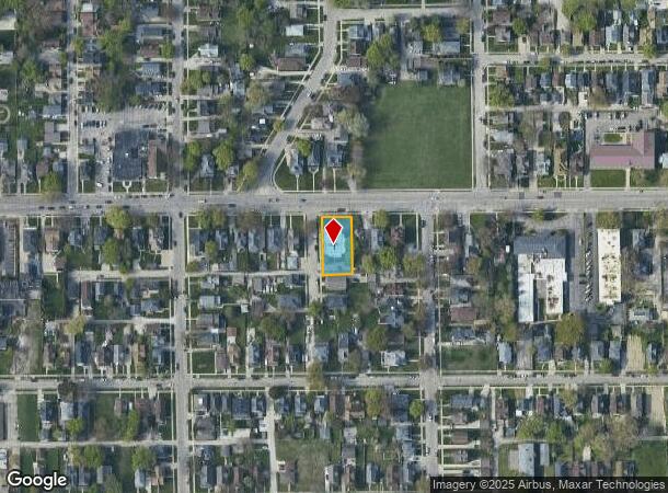
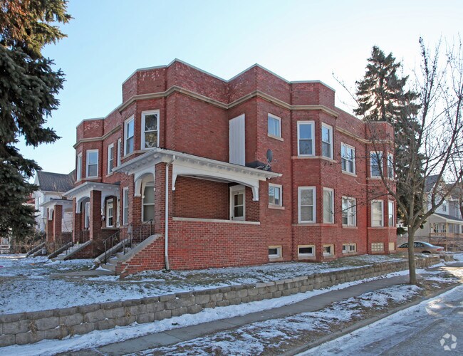
Property Record
1819 60Th St, Kenosha, WI 53140
NEARBY LISTINGS FOR SALE OR LEASE
Property Detail
1819 60Th St
Chicago-Naperville-Elgin, IL-IN-WI
Prairie Su
05-123-06-226-013
LOT 4 & W 30 FT LOT 3 PRAIRIE SUB PT NW 1/4 SEC 6 T1 R23 1980 ALSO PT N 1/2 VAC ALLEY RES #100-08 DOC#1565371 (2009 LOT LINE
Commercialnec
Kenosha
X
Wisconsin
55059C0204E
4
2024
0.27 AC
2024
Columbus
001100
Chicago
6,224 SF
DEMOGRAPHICS near 1819 60Th St
1 Mile
3 Mile
5 Mile
2024 Total Population
19,509
81,664
112,794
2029 Population
18,910
80,524
111,722
Pop Growth 2024-2029
(3.07%)
(1.40%)
(0.95%)
Average Age
37
39
40
2024 Total Households
7,689
32,279
45,004
HH Growth 2024-2029
(3.04%)
(1.37%)
(0.94%)
Median Household Inc
$43,763
$61,662
$66,389
Avg Household Size
2.40
2.40
2.40
2024 Avg HH Vehicles
2.00
2.00
2.00
Median Home Value
$154,440
$180,530
$211,226
Median Year Built
1948
1962
1971
Nearby Places
Map Layers
Map Styles
 Street
 Aerial
- Restaurants
- Banks
- Shops
- Fitness
- Groceries
PUBLIC TRANSPORTATION
TRANSIT/SUBWAY
Kenosha Station (Union Pacific North Line - Northeast Illinois Regional Commuter Railroad (Metra))
DRIVE
WALK
Distance
Kenosha Station (Union Pacific North Line - Northeast Illinois Regional Commuter Railroad (Metra))
3 min
13 min
0.7 mi
COMMUTER RAIL
Kenosha Station (Union Pacific North Line - Northeast Illinois Regional Commuter Railroad (Metra))
DRIVE
WALK
Distance
Kenosha Station (Union Pacific North Line - Northeast Illinois Regional Commuter Railroad (Metra))
3 min
13 min
0.7 mi
Winthrop Harbor Station (Union Pacific North Line - Northeast Illinois Regional Commuter Railroad (Metra))
DRIVE
WALK
Distance
Winthrop Harbor Station (Union Pacific North Line - Northeast Illinois Regional Commuter Railroad (Metra))
15 min
7.8 mi
AIRPORT
General Mitchell International
DRIVE
WALK
Distance
General Mitchell International
45 min
32.6 mi
Nearby Properties
Address
Land Use
TOTAL SIZE
Lot Size
Zoning
Address
Land Use
TOTAL SIZE
Lot Size
Zoning
35,092 SF
26.34 AC
B2
Address
Land Use
TOTAL SIZE
Lot Size
Zoning
183,173 SF
9.73 AC
RM3
Address
Land Use
TOTAL SIZE
Lot Size
Zoning
32,245 SF
22 AC
RM2
Address
Land Use
TOTAL SIZE
Lot Size
Zoning
26,016 SF
14.02 AC
FW
Address
Land Use
TOTAL SIZE
Lot Size
Zoning
10.37 AC
IP
Address
Land Use
TOTAL SIZE
Lot Size
Zoning
357,885 SF
26.58 AC
M1
Address
Land Use
TOTAL SIZE
Lot Size
Zoning
76,848 SF
8.09 AC
BASE
Address
Land Use
TOTAL SIZE
Lot Size
Zoning
28,815 SF
1.04 AC
B3
Address
Land Use
TOTAL SIZE
Lot Size
Zoning
17,174 SF
10.31 AC
RS2
Address
Land Use
TOTAL SIZE
Lot Size
Zoning
0.62 AC
Address
Land Use
TOTAL SIZE
Lot Size
Zoning
12.38 AC
M1
Address
Land Use
TOTAL SIZE
Lot Size
Zoning
67,850 SF
5.51 AC
B2
Address
Land Use
TOTAL SIZE
Lot Size
Zoning
63,500 SF
5.81 AC
RM2
Address
Land Use
TOTAL SIZE
Lot Size
Zoning
147,040 SF
2.50 AC
RM2
Address
Land Use
TOTAL SIZE
Lot Size
Zoning
92,358 SF
8.72 AC
B2
Address
Land Use
TOTAL SIZE
Lot Size
Zoning
59,660 SF
1.22 AC
RM3
Address
Land Use
TOTAL SIZE
Lot Size
Zoning
39.98 AC
BASE
Address
Land Use
TOTAL SIZE
Lot Size
Zoning
84,950 SF
8.11 AC
Address
Land Use
TOTAL SIZE
Lot Size
Zoning
31,650 SF
7.62 AC
FW
Address
Land Use
TOTAL SIZE
Lot Size
Zoning
71,277 SF
14.28 AC
B2
Address
Land Use
TOTAL SIZE
Lot Size
Zoning
135,468 SF
13.56 AC
B2
Address
Land Use
TOTAL SIZE
Lot Size
Zoning
60,657 SF
4.42 AC
RM3
Address
Land Use
TOTAL SIZE
Lot Size
Zoning
319,640 SF
19.20 AC
M1
Address
Land Use
TOTAL SIZE
Lot Size
Zoning
61,318 SF
6.17 AC
B2
Address
Land Use
TOTAL SIZE
Lot Size
Zoning
88,867 SF
8.32 AC
B2
Address
Land Use
TOTAL SIZE
Lot Size
Zoning
32,000 SF
3.97 AC
IP
Address
Land Use
TOTAL SIZE
Lot Size
Zoning
80,684 SF
7.05 AC
B2
Address
Land Use
TOTAL SIZE
Lot Size
Zoning
116,227 SF
10.60 AC
B2
Address
Land Use
TOTAL SIZE
Lot Size
Zoning
3.72 AC
Address
Land Use
TOTAL SIZE
Lot Size
Zoning
21,060 SF
7.02 AC
RM2
The World's #1 Commercial Real Estate Marketplace
Connect with us
© 2025 CoStar Group
The information above has been obtained from sources believed reliable. While we do not doubt its accuracy we have not verified it and make no guarantee, warranty or representation about it. It is your responsibility to independently confirm its accuracy and completeness. Any projections, opinions, assumptions, or estimates used are for example only and do not represent the current or future performance of the property. The value of this transaction to you depends on tax and other factors which should be evaluated by your tax, financial, and legal advisors. You and your advisors should conduct a careful, independent investigation of the property to determine to your satisfaction the suitability of the property for your needs.