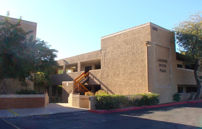
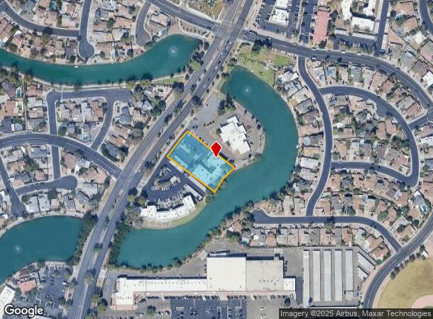
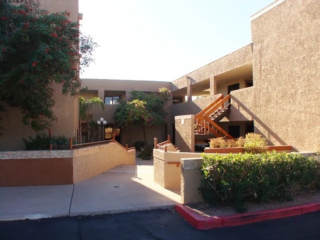
Property Record
1819 S Dobson Rd, Mesa, AZ 85202
Current Lease Availabilities
NEARBY LISTINGS FOR SALE OR LEASE
Property Detail
1819 S Dobson Rd
Phoenix-Mesa-Chandler, AZ
Los Altos Amd
305-02-427D
LOS ALTOS AMD MCR 167-27
Officebuilding
Maricopa
X
Arizona
04013C2244L
p
2025
0.94 AC
2025
Superstition Corridor
422223
Phoenix
16,649 SF
DEMOGRAPHICS near 1819 S Dobson Rd
1 Mile
3 Mile
5 Mile
2024 Total Population
15,588
157,852
409,165
2029 Population
16,945
170,081
440,830
Pop Growth 2024-2029
+ 8.71%
+ 7.75%
+ 7.74%
Average Age
42
37
36
2024 Total Households
6,674
64,519
160,169
HH Growth 2024-2029
+ 8.90%
+ 7.88%
+ 7.97%
Median Household Inc
$70,288
$63,791
$65,296
Avg Household Size
2.20
2.40
2.40
2024 Avg HH Vehicles
2.00
2.00
2.00
Median Home Value
$351,988
$343,742
$350,430
Median Year Built
1978
1979
1982
Nearby Places
Map Layers
Map Styles
 Street
 Aerial
- Restaurants
- Banks
- Shops
- Fitness
- Groceries
PUBLIC TRANSPORTATION
AIRPORT
Phoenix Sky Harbor International
DRIVE
WALK
Distance
Phoenix Sky Harbor International
19 min
11.6 mi
Phoenix-Mesa Gateway
DRIVE
WALK
Distance
Phoenix-Mesa Gateway
27 min
18.1 mi
Nearby Properties
Address
Land Use
TOTAL SIZE
Lot Size
Zoning
Address
Land Use
TOTAL SIZE
Lot Size
Zoning
439,211 SF
77.92 AC
C-G
Address
Land Use
TOTAL SIZE
Lot Size
Zoning
918,576 SF
22.96 AC
C-N
Address
Land Use
TOTAL SIZE
Lot Size
Zoning
1,418,890 SF
39 AC
PF
Address
Land Use
TOTAL SIZE
Lot Size
Zoning
805,814 SF
115.19 AC
C-G
Address
Land Use
TOTAL SIZE
Lot Size
Zoning
860,343 SF
56.83 AC
I-1
Address
Land Use
TOTAL SIZE
Lot Size
Zoning
30,075 SF
6.86 AC
I-1
Address
Land Use
TOTAL SIZE
Lot Size
Zoning
937,488 SF
40.63 AC
R-4
Address
Land Use
TOTAL SIZE
Lot Size
Zoning
739,944 SF
40.02 AC
MFM
Address
Land Use
TOTAL SIZE
Lot Size
Zoning
15,050 SF
1.42 AC
C-G
Address
Land Use
TOTAL SIZE
Lot Size
Zoning
459,103 SF
13.27 AC
MU4
Address
Land Use
TOTAL SIZE
Lot Size
Zoning
782,618 SF
6.70 AC
PAD
Address
Land Use
TOTAL SIZE
Lot Size
Zoning
485,625 SF
45.99 AC
PF
Address
Land Use
TOTAL SIZE
Lot Size
Zoning
177,897 SF
17.81 AC
AG
Address
Land Use
TOTAL SIZE
Lot Size
Zoning
32,619 SF
2.40 AC
C-G
Address
Land Use
TOTAL SIZE
Lot Size
Zoning
13,336 SF
1.98 AC
I-2
Address
Land Use
TOTAL SIZE
Lot Size
Zoning
411,683 SF
15.53 AC
RM3
Address
Land Use
TOTAL SIZE
Lot Size
Zoning
357,952 SF
33.73 AC
LI
Address
Land Use
TOTAL SIZE
Lot Size
Zoning
175,866 SF
12.46 AC
AG
Address
Land Use
TOTAL SIZE
Lot Size
Zoning
428,895 SF
14.66 AC
PAD
Address
Land Use
TOTAL SIZE
Lot Size
Zoning
317,115 SF
36.47 AC
R-6
Address
Land Use
TOTAL SIZE
Lot Size
Zoning
418,678 SF
18.63 AC
C-G
Address
Land Use
TOTAL SIZE
Lot Size
Zoning
23,030 SF
0.99 AC
M-H
Address
Land Use
TOTAL SIZE
Lot Size
Zoning
36,180 SF
59.51 AC
AG
Address
Land Use
TOTAL SIZE
Lot Size
Zoning
572,119 SF
22.45 AC
PF
Address
Land Use
TOTAL SIZE
Lot Size
Zoning
291,833 SF
36.86 AC
R-6
Address
Land Use
TOTAL SIZE
Lot Size
Zoning
570,051 SF
4.26 AC
Address
Land Use
TOTAL SIZE
Lot Size
Zoning
315,463 SF
9.85 AC
C-G
Address
Land Use
TOTAL SIZE
Lot Size
Zoning
632,909 SF
5.83 AC
C-G
Address
Land Use
TOTAL SIZE
Lot Size
Zoning
236,706 SF
16.54 AC
I-1
Address
Land Use
TOTAL SIZE
Lot Size
Zoning
154,157 SF
7.22 AC
I-1
The World's #1 Commercial Real Estate Marketplace
Connect with us
© 2026 CoStar Group
The information above has been obtained from sources believed reliable. While we do not doubt its accuracy we have not verified it and make no guarantee, warranty or representation about it. It is your responsibility to independently confirm its accuracy and completeness. Any projections, opinions, assumptions, or estimates used are for example only and do not represent the current or future performance of the property. The value of this transaction to you depends on tax and other factors which should be evaluated by your tax, financial, and legal advisors. You and your advisors should conduct a careful, independent investigation of the property to determine to your satisfaction the suitability of the property for your needs.